
Dal Richards on a television set
- AM1205-S3-F5-: CVA 1205-40
- Item
- Mar. 24, 1954
Part of Dal Richards fonds
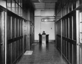
Item is a photograph possibly showing the interior of CBC television studio 40. Identified is Lorraine McAllister standing centre.
52 results directly related Exclude narrower terms
Dal Richards on a television set
Part of Dal Richards fonds
Item is a photograph possibly showing the interior of CBC television studio 40. Identified is Lorraine McAllister standing centre.
Map of Vancouver and Lower Mainland : avenue guide
Part of City of Vancouver Archives technical and cartographic drawing collection
Map includes Lower Mainland, B.C. and shows streets, railways, street cars, bus lines, schools, parks and industry.
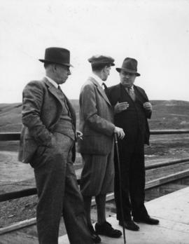
B. Russell, Lord Tweedsmuir and John Vallance at the Val Marie Dam
Part of Gordon Brown fonds

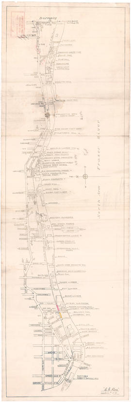
Businesses along the north shore of the North Arm of the Fraser River
Item is a map showing the locations and names of businesses located along the north shore of the North Arm of the Fraser River.
Ross, C.E.

B.C. Pulp and Paper Mill : Port Alice, B.C. : Aug. 1929
Part of William Malkin fonds
Photograph shows a view of Port Alice mill and townsite with mountains in background.

Part of McGuigan family fonds


T.G. McBride and Company Bunkers : Crane

Part of Bell-Irving family collection
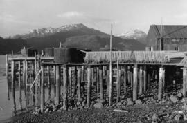
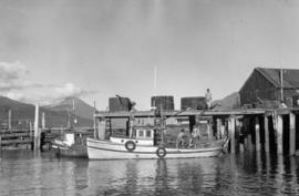
Arrandale cannery and buildings along wharf with floating dock and boats
Part of Bell-Irving family collection

Arrandale cannery and buildings along wharf with floating dock and boats
Part of Bell-Irving family collection

Workers unloading fish from fishing scow
Part of Bell-Irving family collection

Fishing scow "Fir Leaf" at wharf of cannery
Part of Bell-Irving family collection

Part of Bell-Irving family collection
Photograph shows docks, nets, boats and workers.

Part of Bell-Irving family collection
Photograph shows docks, nets, boats and workers.

Part of Bell-Irving family collection
Photograph shows docks, nets, boats and workers.
Part of Bell-Irving family collection
Photograph shows docks, nets, boats and workers.
Part of Bell-Irving family collection

Part of Bell-Irving family collection
Photograph shows women at work on an assembly line.
Part of Bell-Irving family collection
Photograph shows a woman receptionist at enquiry desk with telephone.

Part of Bell-Irving family collection

Part of Bell-Irving family collection
Photograph shows trays of cans in front of cookers.

Three parked cars bearing advertisements for canned salmon, T.A. James Specialty Corp.
Part of Bell-Irving family collection

Cases of salmon stacked at Philadelphia train depot
Part of Bell-Irving family collection

Cases of salmon stacked at train depot
Part of Bell-Irving family collection

3327 cases of salmon stacked for shipment by P.E. Harris & Co. via S.S. Victoria from False Pass
Part of Bell-Irving family collection

Men unloading salmon from scow at dockside
Part of Bell-Irving family collection

Cannery with an fish processing machine in the foreground
Part of Bell-Irving family collection

Interior of cannery with women and children working at machines
Part of Bell-Irving family collection

Vancouver, B.C. 1890 : built-on area
Part of City of Vancouver Archives technical and cartographic drawing collection
Item is a map showing downtown Vancouver and a portion of east Vancouver. City blocks, buildings and railway lines are shown. Annotations in pencil mark the location of Granville Bridge, Main Street Bridge, the Vancouver Lumber Company, the Canadian Pacific Railway station, the Hastings Sawmill, False Creek and Burrard Inlet.
Holdsworth, Derek
Vancouver, British Columbia : [urban analysis maps]
Part of City of Vancouver Archives technical and cartographic drawing collection
Maps show land use, land slope and elevation, density of buildings, structural material of buildings, height of buildings, water supply systems, sewage systems, electric power systems, gas trunk systems, population distribution, daytime population distribution, dwelling units, schools, hospitals and doctors, land transportation, port facilities, food manufacturing, textile manufacturing, wood product manufacturing, metal product manufacturing, transportation equipment manufacturing, non-metallic mineral and chemical products manufacturing, retail and wholesale food enterprises, retail and wholesale building materials enterprises, retail and wholesale drugs, general merchandise, apparel and accessories enterprises, retail and wholesale clothing and shoes enterprises, retail and wholesale furnishing enterprises and hotels and eating places in the Greater Vancouver area (including West Vancouver, North Vancouver, Vancouver, Burnaby, New Westminster, the northern portion of Richmond and the western portion of Coquitlam). Much of the data for these maps was derived from the 1961 census of Canada.
![Granville [Townsite], B.C. Aug., 1885](/uploads/r/null/1/a/4/1a45ddd637fe3f3726748d5096017a8461446b9a013c408ed2b1666c8433e1f9/405fdc0d-6d88-41b7-937f-36cc7f51518a-MAP553_142.jpg)
Granville [Townsite], B.C. Aug., 1885
Part of City of Vancouver Archives technical and cartographic drawing collection
Item is a fire insurance map of the "Coal Harbour" [south shore of Burrard Inlet] area. The Hastings Saw Mill Company and Coal Harbour Fishery are shown in detail. Other businesses along Front Street are identified including hotels and stores.
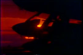
Part of Yaletown Productions Inc. fonds
Item is a Yaletown Productions demo tapes with segments from programs produced. Includes brief advertisements for Vancouver Helicopters, TCG International, NORSAT International, Petro Canada, CAATS [Canadian Automated Air Traffic System], and Speedy Auto Glass.
Composite industrial map of metropolitan area : Lower Mainland, British Columbia
Item is a map showing railroads, main traffic arteries, new housing developments, lot numbers, municipal boundaries and industrial areas in Vancouver, West Vancouver, North Vancouver, Coquitlam, Delta, Richmond and Surrey. Industrial areas are categorised according to the following: existing heavy industry, potential heavy industry, existing light industry and potential light industry. The item also includes a breakdown of industrial areas by acreages.
Composite industrial map of the metropolitan area, Lower Mainland, British Columbia
Part of City of Vancouver Archives technical and cartographic drawing collection
Item is a map showing areas either occupied by industry or zoned for industry in the following municipalities of the Lower Mainland: Vancouver, New Westminster, North Vancouver, Port Coquitlam, Port Moody, Burnaby, Coquitlam, Delta, North Vancouver, Richmond, Surrey and West Vancouver. Industrial areas are categorized as either light or heavy industry. New housing developments, main traffic arteries, railways and municipal boundaries are also indicated.
Canadian National Railways mountain region : Vancouver, B.C.
Part of City of Vancouver Archives technical and cartographic drawing collection
Item is a map showing major roads, highways, railways and industrial centres in the Lower Mainland (from Langley west). The map shows nine different railway lines and the Roberts Bank development, with land described based on four categories: First stage - causeway plus 50 acres; Federal government - ultimate development; Provincial government - reclaimed industrial land; and Provincial government - assembled land.
![WHC APWA [American Public Works Association?] Presentation [31 of 32]](/uploads/r/null/6/2/62aca4ffc2604db1005fd1f1f1bbb993be7a878f0f88eac2325736e01463f020/450e7c65-370e-4726-bbde-26f8dd78feab-A69006_142.jpg)
WHC APWA [American Public Works Association?] Presentation [31 of 32]
Part of City of Vancouver fonds
![WHC APWA [American Public Works Association?] Presentation [32 of 32]](/uploads/r/null/b/8/b853f8c85425ab53956f98823a6ac88068bd4f4d6b472d503b7808796cdad376/1f2acd09-2300-4203-98ae-75a7a14f9f6a-A69007_142.jpg)
WHC APWA [American Public Works Association?] Presentation [32 of 32]
Part of City of Vancouver fonds
![WHC APWA [American Public Works Association?] Presentation [30 of 32]](/uploads/r/null/6/a/6a7dc155f47193b632f4f341e40e9897e842c99d8e2c8440fc6d16250406050e/1aef7383-f60a-4ada-ad7a-02788cba56df-A69005_142.jpg)
WHC APWA [American Public Works Association?] Presentation [30 of 32]
Part of City of Vancouver fonds
![Miscellaneous [102 of 130]](/uploads/r/null/c/2/c2f4499f0e77383c330e21ed2f341200fa771698e5a42ef58229230e3ffa00ef/28190a65-a694-431a-b5a9-90d2046a600f-A67534_142.jpg)
Part of City of Vancouver fonds
![Miscellaneous [88 of 130]](/uploads/r/null/8/7/871b39c8f248174fba91bea2c574ce09142ee06a865e6af549aa2a3748a4be42/0c68cd0c-6ad2-4150-9970-ad52bc8d8ee5-A67520_142.jpg)
Part of City of Vancouver fonds

Map of south western British Columbia showing coastal lumber producers
Primary map shows lumber shippers and producers in the Lower Mainland and Vancouver Island. Inset maps show lumber shippers and producers in Greater Vancouver and the location of the primary map in relation to the rest of Canada.

Part of City of Vancouver Archives technical and cartographic drawing collection
Item is a map showing the locations and names of major businesses and corporations in the Greater Vancouver area. The map also shows major roads, highways, railways and proposed highway routes. 5 mile and 10 mile radius circles are depicted around the "geographical centre of metropolitan Vancouver." Map background is a mosaic of aerial photographs.

Plan of the City of Vancouver, B.C.
Part of City of Vancouver Archives technical and cartographic drawing collection
Item is a map of the old City of Vancouver south to 16th Avenue. The map depicts District Lots and blocks, railway lines, street car lines, industrial areas, parks, postal information, schools, property boundaries.
Greater Vancouver and Fraser Valley
Part of City of Vancouver Archives technical and cartographic drawing collection
Item is a pamphlet containing a map of Greater Vancouver and the Fraser Valley on one side and text promoting British Columbia and the services of Western Development and Power Limited on the other. Map shows the B.C. Electric railway line within the Greater Vancouver and Fraser Valley area, other railway lines, main roads, municipal boundaries, industrial sites, airports and ports. An inset map shows the total area served by B.C. Electric within British Columbia and the location of Greater Vancouver and the Fraser Valley within that area.

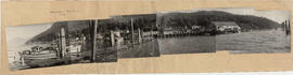
Aerial view of Malkin Bowl, Stanley Park and waterfront industries