![[The blacksmith shop at West Coast Shipbuilders Limited]](/uploads/r/null/e/c/ec160dfb1958dabc1843a2f33fe3036c5986fc7b4408d8b1f0aa690084f4b91f/638ab269-3753-4961-9b6b-f989a2bb6a46-A46245_142.jpg)
[The blacksmith shop at West Coast Shipbuilders Limited]
- AM54-S4-1-M-7-: M-7-35
- Item
- Jan. 29, 1942
Part of Major Matthews collection
456 results directly related Exclude narrower terms
[The blacksmith shop at West Coast Shipbuilders Limited]
Part of Major Matthews collection
![[The blacksmith shop at West Coast Shipbuilders Limited]](/uploads/r/null/7/f/7f48e2701abecb7bd2fff01bc507aff9cc2c5c3e5a4b0a892fa6a8bbc7640d6b/52ff6f43-be93-42d0-b18e-3c4c175ec004-A37285_142.jpg)
[The blacksmith shop at West Coast Shipbuilders Limited]
Photograph shows West First Avenue at Columbia Street
![[The blacksmith shop at West Coast Shipbuilders Limited]](/uploads/r/null/b/2/b2e7b8f123b89dc1f6eafe650e6ca3c63a7fd7d6402b41adcc8f8993b60bb1b1/65b00e33-2004-4daf-91c8-ee57743aa9b5-A37282_142.jpg)
[The blacksmith shop at West Coast Shipbuilders Limited]
Panoramic view
![[The Brisbane Aviation Company Limited building at Vancouver Civic Airport]](/uploads/r/null/1/3/13abff5d904187e12a62734801e8dba7e99c1a48075055d792078ba7182f9a9c/cdb97dbe-9dd6-492b-b377-2c1a1cf6cfe8-A60581_142.jpg)
[The Brisbane Aviation Company Limited building at Vancouver Civic Airport]
Part of Major Matthews collection
![[The Iron Works, New Westminster, after great fire]](/uploads/r/null/8/3/830001783b6f6208a0d930bef900bfec8744694026defbc4178ea20a8f3a677c/185d815e-2079-4c0f-bdb8-851dbb512be0-A19548_142.jpg)
[The Iron Works, New Westminster, after great fire]
Part of Major Matthews collection

The "Jungle" of the unemployed, summer of 1931
Part of Major Matthews collection
The National Drug Co. warehouse drug floor
The sundry floor of the National Drug Co. warehouse

Truck (Reo) Champion and White Ltd. builders supplies
Part of Stuart Thomson fonds
![[Two views of Walsh Construction Company and Vancouver Lumber Company, Roche Point]](/uploads/r/null/0/1/013502406fee6f1750799b504583387029434af1a7a6b486a849aff5ceed3584/8a0b0f30-1518-43f4-ab43-a7c0fca56ee1-A63951_142.jpg)
[Two views of Walsh Construction Company and Vancouver Lumber Company, Roche Point]
Part of Major Matthews collection
![United Distillers Limited [exterior of plant at 8900 Shaughnessy Street]](/uploads/r/null/6/7/673764acea218ee89f5cc937efc6d8ebb24e1501461845ad90db1f8e10e98a8f/1c6fa645-fadf-4c70-9458-467c0195034a-A06308_142.jpg)
United Distillers Limited [exterior of plant at 8900 Shaughnessy Street]
[Vancouver Board of Trade Excursion to Okanagan and Kootenays August 21 to September 5, 1926]
Part of L.D. Taylor family fonds
File consists of photographs of a British Columbia interior tour made by Mayor L.D. Taylor and thirty-eight other members of the Vancouver Board of Trade. Includes photographs of the East Kootenay Power Company on the Elk River, West Kootenay Power Company at Bonnington, Lower Bonnington Power Plant, Crow's Nest Coal Company, Dominion Experimental Station in Summerland, Eldorado Arms Hotel, Sicamous Hotel, Kootenay National Park, Invermere and Oliver.
![Vancouver Breweries [exterior view, wooden and corrugated metal siding building]](/uploads/r/null/f/5/f5ec9b2d6e33b9c97d4fe8bb9ac7c7accaf50865062b94fdb90c4afb4e615536/5aa81231-463a-4fce-ad0b-cdafe02f3f2d-A01733_142.jpg)
Vancouver Breweries [exterior view, wooden and corrugated metal siding building]
Part of Stuart Thomson fonds
![Vancouver Breweries [interior]](/uploads/r/null/d/a/f/daf4302752a7069fda43a500f2e94f594c1ea3479529dab9da6f74adbb5a945c/7761fec7-1338-4a4b-b1da-5518e0451951-CVA99-6560_142.jpg)
Vancouver Breweries [interior]
Part of Stuart Thomson fonds
![Vancouver Breweries [interior, workers packing barrels]](/uploads/r/null/c/e/1/ce1c4c96f6611a05e5ea3942b00a4dde972f0af7d53a32013e67eb4295ad120b/91b7c980-66ae-4d12-b27a-2f12398a33ac-CVA99-6561_142.jpg)
Vancouver Breweries [interior, workers packing barrels]
Part of Stuart Thomson fonds
![Vancouver Breweries Ltd. [2700 Yew, corner 11th Avenue]](/uploads/r/null/b/8/b8e77da3b864f6aadf3aa76e9dca0a1e5f770f3919503dbb955d9918c8db2b80/84df7584-5055-48c5-8049-b0dc4da2cf5a-A01728_142.jpg)
Vancouver Breweries Ltd. [2700 Yew, corner 11th Avenue]
Part of Stuart Thomson fonds
![Vancouver Breweries Ltd. [interior view - mechanics]](/uploads/r/null/d/8/d8d341b1d329853753f630e423090a22bf3429659075d4a278ac631be3010e76/4596f4a5-d3b2-452d-ab32-6f670d668b92-A01730_142.jpg)
Vancouver Breweries Ltd. [interior view - mechanics]
Part of Stuart Thomson fonds
![Vancouver Breweries Ltd. [interior view - mechanics]](/uploads/r/null/6/0/60afa088816e907f8851d2f4da31985a02ae1a272c2a4970900806da6805a42c/6f77c5cd-0d2b-498a-8ea1-0ecc7b8de3ab-A01729_142.jpg)
Vancouver Breweries Ltd. [interior view - mechanics]
Part of Stuart Thomson fonds
![Vancouver Breweries Ltd. [interior view - mechanics]](/uploads/r/null/0/5/059db5d37cd849259b1d612eaf9f24c8416ee001a47ca731e645f1aab63d319b/67a91688-afdf-4d51-9962-10c2c2fa4683-A01732_142.jpg)
Vancouver Breweries Ltd. [interior view - mechanics]
Part of Stuart Thomson fonds
![Vancouver Breweries Ltd. [interior view - mechanics]](/uploads/r/null/3/e/3eca57a6ddc0d0ae36b2c23d981031441f8563b8a19a8ea6051af1b65a21b456/5e527813-23b7-4e4a-92ea-e617f5d10d0d-A01731_142.jpg)
Vancouver Breweries Ltd. [interior view - mechanics]
Part of Stuart Thomson fonds
![Vancouver Brewery [interior view - front office]](/uploads/r/null/3/4/3406a5d3df320d716d9dfe902739bea05f04fadcade70f2e2717020fbbb163e8/988c9525-9712-4823-95fd-5f30f349d1cb-A01735_142.jpg)
Vancouver Brewery [interior view - front office]
Part of Stuart Thomson fonds
![Vancouver Brewery [interior view - men crating bottles of beer]](/uploads/r/null/b/8/b868f68fd9695b118d41c82fa4048c82e64b4a452ef0b22336dce12484eb2c83/942eb9d8-b084-4e95-ae98-30742c26ee50-A01736_142.jpg)
Vancouver Brewery [interior view - men crating bottles of beer]
Part of Stuart Thomson fonds
![Vancouver Brewery [interior view - warehouse]](/uploads/r/null/b/e/beaf5043bd02b4345b3138d9ae92c6fd5909eb7aa9183a9e8dca3de88bc35d5c/bd1b52b6-3cf7-4363-8b35-ce16919f4e7a-A01734_142.jpg)
Vancouver Brewery [interior view - warehouse]
Part of Stuart Thomson fonds

Panoramic view showing Burrard Inlet including 42 ocean steamers in port of which 25 were for grain cargoes, 17 vessels at berth (not shown in photograph) and the Harbour Commissioners wharf and Grain Elevator No. 1 and log booms

Part of Major Matthews collection
Panoramic view showing Burrard Inlet including 42 ocean steamers in port of which 25 were for grain cargoes, 17 vessels at berth (not shown in photograph) and the Harbour Commissioners wharf and Grain Elevator No. 1 and log booms

Vancouver Iron and Engineer Workers buildings, False Creek
Part of Elizabeth Walker fonds
Item is a photograph showing Vancouver Iron and Engineer Workers buildings. Photo taken during a tour of False Creek.
![Vancouver Iron [and Engineering] Works [Ltd. at 1155 West 6th Avenue]](/uploads/r/null/e/6/e6a863f6dac21b50be8367e8e5750691baffa19601e5c20b94bf689cebc0c652/bef90d24-f0c4-4d0d-b5fc-0b7d2650917e-A59351_142.jpg)
Vancouver Iron [and Engineering] Works [Ltd. at 1155 West 6th Avenue]
Part of City of Vancouver fonds
![Vancouver Iron [and Engineering] Works [Ltd. at 1155 West 6th Avenue]](/uploads/r/null/6/b/6be9697c52433ad1920fd5e29cb57959e27c9ecca3baa1946998a8ac3bce7fa1/6627b3c4-5254-4eae-b655-7375303a79e4-A59355_142.jpg)
Vancouver Iron [and Engineering] Works [Ltd. at 1155 West 6th Avenue]
Part of City of Vancouver fonds
Photograph also shows the Granville Bridge
![Vancouver Iron [and Engineering Works Ltd. at 1155 West 6th Avenue]](/uploads/r/null/b/7/b74c6e707f8da3839d570aaa81240f9563aa96f7b9fe91496abef63532e7e1bd/56cc4df7-6d35-4ea2-b5d4-a3de0c04bdd5-A59356_142.jpg)
Vancouver Iron [and Engineering Works Ltd. at 1155 West 6th Avenue]
Part of City of Vancouver fonds

Vancouver Iron Works and Foundry
Part of Major Matthews collection
Sign on building reads: Vancouver City Foundry and Machine Works.
Part of Major Matthews collection
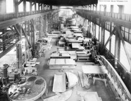
Photograph shows a view of equipment on the shop floor
![[Vancouver Machinery Depot buildings]](/uploads/r/null/a/5/a50edf1ca4b0b1cf05264c2d975662e3f7d89a3871e8b243e850aba60f01e748/7174f178-c52a-4c8a-8402-9c7ffbd6ecac-A63488_142.jpg)
[Vancouver Machinery Depot buildings]
Part of Major Matthews collection
Photograph also shows the Gulf of Georgia Towing Co. and Cedar Coe Sash and Door Co. buildings.

Part of Major Matthews collection
J.S. Matthews' notes with print or negative in Archives.
![Vancouver Rowing Club Regatta [Coal Harbour - showing arena and Boeing Aircraft Co.]](/uploads/r/null/e/a/ea54cea44c9c74a0bba090ec993317b2c0ff8fb47f8538ad1f889ce74ec5c08d/2e5a6032-993d-4542-acdf-1ad1a73d5cf8-A01210_142.jpg)
Vancouver Rowing Club Regatta [Coal Harbour - showing arena and Boeing Aircraft Co.]
Part of Stuart Thomson fonds
![Vancouver Rowing Club Regatta [Coal Harbour - showing Boeing Aircraft Co. building]](/uploads/r/null/c/6/c6d6849ea715efde8af2d533f3ba0c6ba4bb2fb98ec57df43e9ca16543fd35a5/692289d1-22e8-48a1-88ab-cc2684daab1b-A01211_142.jpg)
Vancouver Rowing Club Regatta [Coal Harbour - showing Boeing Aircraft Co. building]
Part of Stuart Thomson fonds
![Victory Flour Mills Ltd. [806 Beach Avenue]](/uploads/r/null/0/1/013ee297589dea04738257135adee6d9ce083cbd5df409323f2b3359c973ca73/8d5b3564-11d9-4620-a061-7d73a48afa09-A00068_142.jpg)
Victory Flour Mills Ltd. [806 Beach Avenue]
Part of Stuart Thomson fonds
View from downtown looking east
Item is a photograph taken from Harbour Centre [?] looking east at Water Street and East Cordova Street, following the waterfront up to around Dunlevy Avenue. Buildings visible include the Hotel Europe marking the intersection of Carrall and Alexander Streets, former Public Safety Building, and St. James Anglican Church.
![[View looking north showing the new Granville Bridge under construction]](/uploads/r/null/a/c/ac614864438f7de31582fc06da740754224f056479955f6b39950abc7f02b12c/abf432bb-98a0-49c5-baef-0e9de85da439-A72290_142.jpg)
[View looking north showing the new Granville Bridge under construction]
Construction progress photograph showing the Granville Rooms, Albion Lumber and Millwork and the Burrard Bridge and the Hotel Vancouver in the background
![[View of Walsh Construction Company and Vancouver Lumber Company, Roche Point]](/uploads/r/null/7/4/74a291b4c22874f372bf133bdf98c42fbe97ed4e46a76bdc028f47b03b626232/f6326306-0c84-439d-9187-00515300be58-A63952_142.jpg)
[View of Walsh Construction Company and Vancouver Lumber Company, Roche Point]
Part of Major Matthews collection
![[View of a New Westminster shipyard showing wooden ships under construction]](/uploads/r/null/9/7/97f48a7b91788bfc7018d739a7b8e75312bca9c69725812348e333f903ab5ca5/c7d95d18-1915-484a-84b8-aaa245b6a9c1-A63590_142.jpg)
[View of a New Westminster shipyard showing wooden ships under construction]
Part of Major Matthews collection
Photograph also shows sawmills across the river.
![[View of building with sign for Reid's Moving & Storage]](/uploads/r/null/f/f/1/ff1a6467679c8bfc437b2030bd8fc941dd838e7deebb519f7d74a8fbca7c2d80/d2c88bc6-7a92-40d1-a3d4-086dbb64619a-CVA1095-02815_142.jpg)
[View of building with sign for Reid's Moving & Storage]
Part of City of Vancouver fonds
![[View of construction site and industrial buildings]](/uploads/r/null/6/1/b/61baf18a0c5765787d9106458c2ad18c8c2696d912599c7c1ecc342831947ded/d745bcf4-8041-4089-ba0c-7a71c2a3fa64-CVA1095-07236_142.jpg)
[View of construction site and industrial buildings]
Part of City of Vancouver fonds
![[View of construction site and industrial buildings]](/uploads/r/null/d/0/f/d0f6c545e9f4f8cce579b92b0a16a31478f585e71f040bc796885e10a590cfaf/c7f93a27-25e4-4611-af62-0736629a0f8b-CVA1095-07238_142.jpg)
[View of construction site and industrial buildings]
Part of City of Vancouver fonds
![[View of Downtown from the Vancouver Iron and Engineering Works Ltd. at 1155 West 6th Avenue]](/uploads/r/null/3/1/318625c5a9ad983f92e59fa31c7055a196f7feb179dd8dffcedae145a36c5cc5/52732964-6835-4d57-9a91-a7816c96cea0-A59350_142.jpg)
[View of Downtown from the Vancouver Iron and Engineering Works Ltd. at 1155 West 6th Avenue]
Part of City of Vancouver fonds
Item is a photograph taken from Harbour Centre [?] showing the north side of the False Creek in the foreground.
Item is a photograph taken from Harbour Centre [?] showing the downtown from Dunsmuir and Homer Streets, including the Beatty Street Drill Hall and former Canada Post office, the Georgia Viaduct and the north side of the False Creek in the foreground. The Cambie Street Bridge is centre, and the south shore of False Creek and City Hall and other buildings are visible in the background.
Item is a photograph taken from Harbour Centre [?] showing the downtown from Dunsmuir and Homer Streets, including the Beatty Street Drill Hall and former Canada Post office, the Georgia Viaduct and the north side of the False Creek in the foreground. The Cambie Street Bridge is centre, and the south shore of False Creek and City Hall and other buildings are visible in the background.
![[View of False Creek from the Burrard Bridge]](/uploads/r/null/a/1/a1fc4701217f9c0ae31c19c9633ecbb4bd755c8cb0943f95eff5cd79ae956917/68e480f6-01eb-4f84-818e-5d3fff88bc4e-A76140_142.jpg)
[View of False Creek from the Burrard Bridge]
Part of James Crookall fonds
Photograph shows the Kitsilano Trestle Bridge and Granville Bridge
![[View of False Creek from the Burrard Bridge]](/uploads/r/null/f/b/fbd61aeef21963d52cdf1d9bebfb76c3f8130414b4beedc138f557b46485122c/c49ef575-2edf-4f80-89cb-0e5daf40eb93-A76141_142.jpg)
[View of False Creek from the Burrard Bridge]
Part of James Crookall fonds
Photograph shows the Kitsilano Trestle Bridge, part of Granville Island (including the B.C. Equipment Co. buildings) and the Granville Bridge
![[View of False Creek looking east from the Granville Street Bridge]](/uploads/r/null/2/e/2e8b77032f573290836c536ceb934c51db17fde801040d82a6e9dab76f86e612/8bda7bf5-4b03-4376-b0b8-58a836dd9261-A09892_142.jpg)
[View of False Creek looking east from the Granville Street Bridge]
Part of Major Matthews collection
Photograph shows barges moored by the British Ropes Canadian Factory Ltd., Wallace Foundry Co. Ltd.and Vulcan Iron Works Ltd.