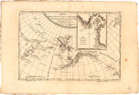
Hydrography

Taxonomy

Code

Scope note(s)

Source note(s)

Display note(s)

Hierarchical terms

Hydrography

Equivalent terms

Hydrography

Associated terms

Hydrography

16 Archival description results for Hydrography

16 results directly related Exclude narrower terms

Fraser River Delta, British Columbia

Item is a map of the Fraser River and Lower Mainland showing the following: roads, electric railways and tramways, bridges, churches, schools, post offices, cemeteries, international, municipal, township and city boundaries, wharves, lighthouses, triangulation stations and boundary monuments. Map gives topography of the land and shows water lines, tidal flats and intermittent streams.

Fraser River to north east point of Texada Island : including Howe Sound and Jervis Inlet

Item is a nautical chart depicting the southern portion of the Strait of Georgia. Land shown includes (south to north): Gulf Islands, Vancouver Island to Nanoose Harbour, Vancouver area, Bowen Island, Gambier Island, Howe Sound, Seechelt Peninsula, and north to Queen's Reach. Inset map is of Tucker Bay on Lasqueti Island. The illustrations are of Georgina Point Lighthouse, Active Pass and the north shore of Gabriola Island.