
Interior of Buntzen Lake hydro electric power station
- AM1376-: CVA 82-01
- Item
- [ca. 1907]
46 results directly related Exclude narrower terms
Interior of Buntzen Lake hydro electric power station

Looking down at interior of Buntzen Lake hydro electric power station

Exterior of Buntzen Lake hydro electric power station
Proposed hydro-electric power development on Cheakamus River
Part of City of Vancouver fonds

General plan of works to be constructed at Nairn Falls. Green Lake. Lillooet District, B.C.
Part of City of Vancouver fonds
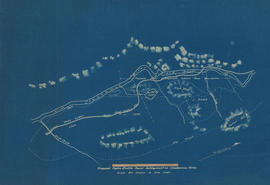
Item is a topographical map showing the location of proposed power house, dam and other hydro-electric infrastructure at the north end of Green Lake, tunnel, and the Pacific Great Eastern Railway right-of-way along the northern edge of Green Lake.
![General plan [of hydro-electric development on Green River]](/uploads/r/null/d/9/e/d9e4c58e28a2189f0c1819b9c491a0478fad0353e2100858ec1eb94c55b96eae/93fa8e5f-c3b7-4e51-802d-979b7bc07f6f-MAP1098_142.jpg)
General plan [of hydro-electric development on Green River]
Part of City of Vancouver fonds
Item is a sheet containing a map of the proposed development and an elevation of the site, showing the dam, tunnel and powerhouse.
Plan of intake for Nairn Falls development. Green River. Lillooet District, B.C.
Part of City of Vancouver fonds
Item is an architectural drawing which depicts 1 elevation and 3 sections of the tunnel intake on the Green River.

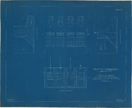
Plan of power house for Nairn Falls development. Green River. Lillooet District, B.C.
Part of City of Vancouver fonds
Item is an architectural drawing depicting 1 site plan and 2 sections of the powerhouse for the Nairn Falls development proposal.
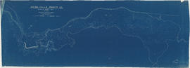
![Plan of fore bay [Nairn Falls hydro electric development]](/uploads/r/null/a/5/5/a55f94fc41cdf02e4a01434daeaf4b6c8715d61bd2a3842a95887e8c7f3371d0/29aba9ea-44a6-4453-9451-4896c8923762-MAP1099_142.jpg)
Plan of fore bay [Nairn Falls hydro electric development]
Part of City of Vancouver fonds
Item is a sheet that contains a map of the location of the dam fore bay, an elevation drawing of the spillway side of the fore bay, 1 section of the fore bay and 2 sections of the fore bay dam.

Longitudinal section on line of power mains
Part of City of Vancouver fonds
Plan of Green Lake showing proposed draw-off works
Part of City of Vancouver fonds
Plan shewing proposed hydro-electric power development on the Cheakamus River B.C.
Part of City of Vancouver fonds

Contour map shewing proposed location of flume, reservoir and power plant Cheakamus River, B.C.
Part of City of Vancouver fonds
Item is a copy of a map that appears to have been created as part of power development proposal by DuCane, Dutcher & Co. The map was likely acquired by the City Engineer's Office as a reference map for surveying work done in the Cheakamus River area in 1923.

Chilliwack Lake scheme & Jones Lake scheme
Part of City of Vancouver fonds
Item is a map depicting proposed hydro-electric development north-west of Chilliwack Lake. The map shows the location so proposed dams, flumes, tunnels and the location of a power house on the Fraser River west of Jones Lake.

Plan of proposed development of hydro-electric power. Bridge River
Part of City of Vancouver fonds
Item is a map sheet containing a plan and profile of a proposed hydro-electric development tunneling water from the Bridge River to a power plant on Seton Lake. The main map shows the plan of the overall development; the inset map is a Key Plan showing the location of the development within British Columbia.

General plan of proposed development of Alouette water power
Part of City of Vancouver fonds


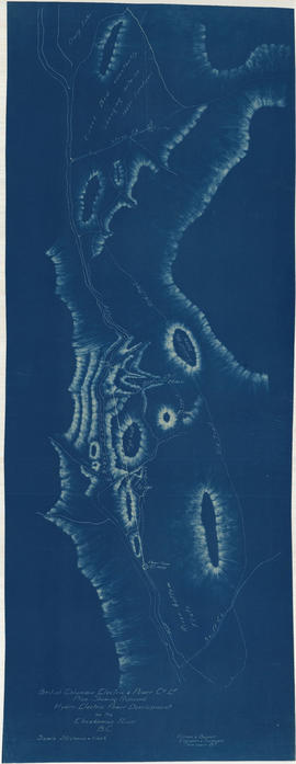
Plan of lands affected by the proposed power development from Bridge River, Lillooet District, BC
Part of City of Vancouver fonds
Item is a map sheet containing various cartographic material: a main map of the Bridge River area, a detail map of the tunnel outlet, a detail map of the proposed dam site, a profile of Mission Mountain, and a profile of the proposed dam site.

Part of City of Vancouver fonds
Item is an architectural drawing sheet depicting a plan and section of the intake on the Bridge River, and the power house on Seton Lake.

Part of City of Vancouver Archives technical and cartographic drawing collection
Part contains a map showing street car, interurban, and motor bus lines in from Vancouver to New Westminster, a map showing existing and projected power plants near Alouette and Stave Lakes, and a profile showing the existing and proposed plants.
Part of City of Vancouver fonds
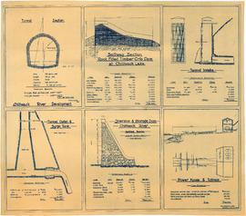
Item is an architectural drawing sheet with six drawings related to proposed hydro electric development on the Chilliwack River: Tunnel section; Spillway section-rock-filled timber crib dam at Chilliwack Lake; Tunnel intake; Tunnel outlet & surge tank; Diversion & storage dam; and Power house and tailrace. Each drawing includes cost and quantity estimates for construction materials.
![[View of] La Gabelle [hydro] plant, four miles below Shawinigan Falls [and surrounding countryside]](/uploads/r/null/e/d/ed69125266023e11664eefa118393ad2495ec34cbad7d21f6b243dac34244f18/3f492b23-f62f-4615-a399-7cebcf454033-CVA275-34_142.jpg)
[View of] La Gabelle [hydro] plant, four miles below Shawinigan Falls [and surrounding countryside]
The Ruskin hydro-electric power development

Southern British Columbia power sites
Part of City of Vancouver fonds
Item is a map showing the location of power generating and survey sites. The map depicts the area from Bridge River, along the Green and Cheakamus Rivers, and along various rivers that are tributaries of the Fraser River in southern British Columbia. The map shows the location of generation sites, flumes, tunnels and pipes, and transmission lines.
The map is in the form of a copy of a map of the region that has been annotated to show these sites. The map is similar to the gauging sites maps MAP 1080.01 and MAP 1080.02
Ruskin power development : completed November 1930
The Bridge River power development

Cheakamus River with proposed dam site at McGuire
Part of City of Vancouver fonds
Item is a sheet with three maps depicting a possible dam site on the Cheakamus River near McGuire: a topographical map of the site with the dam location annotated, and a cross-section depicting the geology of the dam site.

Cheakamus power survey for City of Vancouver 1930-1931. Proposed storage reservoir at Daisy Lake
Part of City of Vancouver fonds
Item is a map sheet containing two maps depicting portions of the Cheakamus River at or near Daisy Lake, with proposed power infrastructure. The sheet also contains charts depicting a capacity diagram for Daisy lake reservoir and cross-sections at Dyke #1 and Dyke #2.

Cheakamus River valley with possible dam location
Part of City of Vancouver fonds
Item is a sheet with three maps depicting a possible dam site on the Cheakamus River: a topographical map of the site with the dam location annotated, a cross-section depicting the geology of the dam site, and a profile of the tentative location of a tunnel.
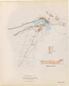
Topography of proposed dam site
Part of City of Vancouver fonds
Item is a sheet with two maps depicting a possible dam site on the Cheakamus River: a topographical map of the site with the dam location annotated, and a cross-section depicting the geology of the dam site.


Well I'll Be Damned! ...A Fish Story!
Item is a pamphlet discussing salmon habitat and arguing against the proposed dam of the Fraser River.
![BC [British Columbia] postcard - The Rockies to the Pacific](/uploads/r/null/1/2/1226936/e2a6b4cf-7e7e-48c3-8e3b-6a150d917129-MI-342_142.jpg)
BC [British Columbia] postcard - The Rockies to the Pacific
Part of Yaletown Productions Inc. fonds
Film is a promotional video for the province of British Columbia. Focusing on different sections of the province in turn the video highlights the features and tourist attractions of each. According to the donor this is most likely the original of the final production with sound and image. Director Mike [Michael] Collier; cinematography Norm Keziere, Dave Geddes, Bob Asgeirsson, Bill Rounds, Tommy Tompkins, and John Anderson; editor Rober Brandreth-Gibbs; research Sharon McGowan; narration script Don White and Sharon McGowan, narrator Art Hives; video services Post Haste Video; film lab Alpha Cine Services; sound mix Pinewood Studios; special thanks to Tourism British Columbia. Produced by Yaletown Productions. b&w 00:10:57-00:11:04 and 00:18:47-00:19:22.
![BC [British Columbia] postcard - The Rockies to the Pacific [Japanese version]](/uploads/r/null/1/2/1226943/1fe338ae-0558-47de-bc78-ac3a556700b9-MI-343_142.jpg)
BC [British Columbia] postcard - The Rockies to the Pacific [Japanese version]
Part of Yaletown Productions Inc. fonds
Film is a promotional video for the province of British Columbia this version has Japanese narration. Focusing on different sections of the province in turn the video highlights the features and tourist attractions of each. According to the donor this is most likely the original of the final production with sound and image. Director Mike [Michael] Collier; cinematography Norm Keziere, Dave Geddes, Bob Asgeirsson, Bill Rounds, Tommy Tompkins, and John Anderson; editor Rober Brandreth-Gibbs; research Sharon McGowan; narration script Don White and Sharon McGowan, narrator Art Hives; video services Post Haste Video; film lab Alpha Cine Services; sound mix Pinewood Studios; special thanks to Tourism British Columbia. Produced by Yaletown Productions. Ends with an advertisement for 'Canada's Best Selling Video Postcard Series.' b&w 00:10:57-00:11:04 and 00:18:47-00:19:22.