
Alix Louise Gordon near lighthouse at Howe Sound
- AM427-S4-F5-: CVA 289-005.308
- Item
- Aug. 1940
Part of William Orson Banfield fonds
59 results directly related Exclude narrower terms
Alix Louise Gordon near lighthouse at Howe Sound
Part of William Orson Banfield fonds

Arbutus Tree on Island Summit, near Hood Point, Howe Sound
A note on the original mounting board reads: "Forestry. The Arbutus Tree on Watch. Island Summit, off Hood Point, Howe Sound, Vancouver, B.C. Van. Nat. History - Timms."
![[Beatrice Timmins, Jane Banfield, Alix Louise Gordon, John Banfield at the] lighthouse, Howe Sound](/uploads/r/null/8/7/2/872e6e037613b7f8ba4a63e93014684f9f7ad67ea6d022cd2684f5da66d9f03b/7a136646-7ebd-41bd-9fc7-6c48f0da431f-CVA289-005_142.jpg)
[Beatrice Timmins, Jane Banfield, Alix Louise Gordon, John Banfield at the] lighthouse, Howe Sound
Part of William Orson Banfield fonds


Cascade Laundry picnic at Seaside Park
Part of Stuart Thomson fonds

Cascade Laundry picnic at Seaside Park
Part of Stuart Thomson fonds

Cascade Laundry picnic at Seaside Park
Part of Stuart Thomson fonds

Cascade Laundry picnic at Seaside Park
Part of Stuart Thomson fonds

Cascade Laundry picnic at Seaside Park
Part of Stuart Thomson fonds

A note on the original mounting board reads: "'The morning's promise.' Early morning on Howe Sound, Vancouver, Canada. Tidal salt water of the Pacific Ocean, explored by Captain Vancouver, over 160 years ago."
Fraser River to north east point of Texada Island : including Howe Sound and Jervis Inlet
Part of City of Vancouver Archives technical and cartographic drawing collection
Item is a nautical chart depicting the southern portion of the Strait of Georgia. Land shown includes (south to north): Gulf Islands, Vancouver Island to Nanoose Harbour, Vancouver area, Bowen Island, Gambier Island, Howe Sound, Seechelt Peninsula, and north to Queen's Reach. Inset map is of Tucker Bay on Lasqueti Island. The illustrations are of Georgina Point Lighthouse, Active Pass and the north shore of Gabriola Island.
Howe Sound - Brackendale : B.C. Hydro/B.C. Tel. poles
Part of City of Vancouver Archives technical and cartographic drawing collection
Item is a topographic map in two sections showing British Columbia north of Burrard Inlet to Britannia Creek in the north, and from Howe Sound in the west to Indian Arm in the east. Map shows lakes, streams and other natural features; roads, railways, communication lines, cities and other built features; and land, timber, and mineral surveys by number.
![Howe Sound - Burrard Inlet [Howe Sound portion]](/uploads/r/null/7/a/1/7a1896077ddc37a7e16ac2d7e42a66031e13e11a9d966c43fca06cbb56f8bd96/5edd8d92-d3cd-4663-8fdd-996b3ae7a402-MAP30a_142.jpg)
Howe Sound - Burrard Inlet [Howe Sound portion]
Part of City of Vancouver Archives technical and cartographic drawing collection
Part shows the Lower Mainland and Howe Sound from Britannia Beach in the northwest to Indian Arm in the southeast. Map shows topographic contour lines, elevations, lakes, streams and other natural features, roads, railways, communication lines, cities and other settlements, and land, timber, and mineral surveys by number.

Howe Sound and Howe Sound (southern portion)
Part of City of Vancouver Archives technical and cartographic drawing collection
Item contains two nautical charts of Howe Sound; one chart shows the southern portion (Bowen Island and Gambier Island) only, while the other shows the Sound from Burrard Inlet in the south to Squamish in the north. Charts show soundings in fathoms, tidal information, bench marks, locations of cables, and characteristics of land at shorelines.

Indian villages and landmarks, Burrard Inlet and Howe Sound before the whitemans came
Part of Major Matthews collection
Item is a manuscript map showing the territory of the Squamish peoples using Squamish geographic names, as told to him by August Jack Khatsahlano.
Matthews, James Skitt, Major
![Liquor Board picnic [picnickers atop water tower, possibly Bowen Island]](/uploads/r/null/4/d/4dc6b4b7f926557aa86a83239c6ba35fb8c013097ee4d16930b9d34634d53bd1/17c88fa3-775f-4c8f-874f-b4c1043b9ad1-A01215_142.jpg)
Liquor Board picnic [picnickers atop water tower, possibly Bowen Island]
Part of Stuart Thomson fonds
![Liquor Board picnic [picnickers climbing water tower, possibly Bowen Island]](/uploads/r/null/0/6/06014e84dd4aede395aaca5eb5079d71d9f4184606cb2d179ad74b9194f95fab/5044fd60-5563-4507-97d0-71cf1f797d5e-A01214_142.jpg)
Liquor Board picnic [picnickers climbing water tower, possibly Bowen Island]
Part of Stuart Thomson fonds
![Liquor Board picnic [Union Steamship's "Lady Alexandra" on excursion run]](/uploads/r/null/8/3/839a45b269f8b36677fe1d038b6640e1ff3cc46573512b614fe83f173904e701/4a5cf805-c34a-474b-9e0d-9b0dcef823fa-A01213_142.jpg)
Liquor Board picnic [Union Steamship's "Lady Alexandra" on excursion run]
Part of Stuart Thomson fonds
![Liquor Board picnic [view from atop water tower]](/uploads/r/null/4/d/4d22b13689a4fc1bcebc2ca0ab6416daa3741040120a0dcfe2b7322a8168611d/2ea06b31-0bd0-4bdf-95b5-33efa89f185e-A01216_142.jpg)
Liquor Board picnic [view from atop water tower]
Part of Stuart Thomson fonds
![Liquor Board picnic [view from atop water tower, joins with CVA 99-2551]](/uploads/r/null/c/c/cc3ba447ae4b17601c4b0fe46cae4d0ee3ee143cff2177a7f8adc34d142f3352/63d630ba-3f92-48e9-b1c8-a50fc4439482-A01218_142.jpg)
Liquor Board picnic [view from atop water tower, joins with CVA 99-2551]
Part of Stuart Thomson fonds
![Liquor Board picnic [view from atop water tower, joins with CVA 99-2552]](/uploads/r/null/a/5/a533ba5f0468b0999180a4aead4f7c4a1879f9c5034a93c330f601280db6c3d8/132eea9d-cd50-433b-8c24-83798262e60e-A01217_142.jpg)
Liquor Board picnic [view from atop water tower, joins with CVA 99-2552]
Part of Stuart Thomson fonds

Looking up Howe Sound from Point Grey
Part of William Orson Banfield fonds

A note on the original mounting board reads: "Seascape. Low tide, salt water, and the disintegrating of shoreline. Miller's Landing, Howe Sound, Vancouver, B.C. Van. Nat. History - Timms."
![[Pasley Island, Howe Sound]](/uploads/r/null/b/4/b4416e1ff672537a3499f43b4cb33a2cd7b54bbb2081898bbe567d3340b0ac84/21e68c75-4793-4e26-bcfe-1f28aa9f6fdc-A20565_142.jpg)
Part of James Luke Quiney fonds
![[Pasley Island, Howe Sound]](/uploads/r/null/3/e/3e16e149c750128ceab4a4a73b096da8bf1b6cd0e3798f3407464d8692f494c9/069f7d41-0f5a-4100-a845-0d44b0faf2e7-A20564_142.jpg)
Part of James Luke Quiney fonds
![[Pasley Island, Howe Sound]](/uploads/r/null/4/2/42d5636cb8d0471b0ed778adab2dd3fe13e5e3de284917155d559c17df82e110/1ebbe0dd-c0b1-4558-bfd7-0809bb8ad9e4-A20566_142.jpg)
Part of James Luke Quiney fonds
![[People diving off a three level diving platform at] Eagle Harbour, on Howe Sound](/uploads/r/null/9/c/9cbf244afdceea5626e734f54d4ae80a2b45b689c84a2ce7e4187211ace234c7/2e0c9918-e8ee-4dfb-8407-759208209080-A71875_142.jpg)
[People diving off a three level diving platform at] Eagle Harbour, on Howe Sound
Part of Karl Haspel fonds
![[Picnic group]](/uploads/r/null/c/0/c0b6f1db6af338c17042d001da60746096d44de405314b97d8c79b7b6b889429/cfce299b-72f7-4f53-8cab-f24fb833c593-A20508_142.jpg)
Part of James Luke Quiney fonds
![[Picnic group at Howe Sound]](/uploads/r/null/7/0/705bf83a3b8fd103b6aac861d555d87c33f932b7c5f104b8b48b9e84292520b9/ad6a6fcc-b397-4c14-9694-c09eb2c75493-A36122_142.jpg)
Part of James Luke Quiney fonds

Part of City of Vancouver Archives technical and cartographic drawing collection
Item is a map of the southwest coast of British Columbia from Cortes Island to Alta Lake and Chilko Lake to the northern tip of Gabriola Island. Map shows timber leases, Crown granted land, parks, municipalities, power lines, roads, railways, elevation of lakes and some mountains, hospitals, schools and canneries.
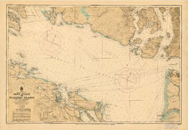
Sand Heads to Ballenas Islands
Part of City of Vancouver Archives technical and cartographic drawing collection
Item is a nautical chart of the Strait of Georgia and the southern portion of Howe Sound. Shows soundings in fathoms, tidal information, bench marks, locations of cables, and characteristics of land at shorelines.

Part of Major Matthews collection
Item is a print of a map by Major James Skitt Matthews, City Archivist, showing villages, landmarks and rivers of Howe Sound and Burrard Inlet using their indigenous names. The map also shows elevations and wildlife populating the area. It was compiled between 1931 and 1937, with the assistance of August Jack Haatsalano (Khahtsahlano), whose attestation is included on the map. Notes on the map explain the map's nomenclature.
Matthews, James Skitt, Major
Union Steamships Ltd. - Photo Record - No. 3
Album contains photographs related to the Howe Sound Ferries by professional photographers Jack Lindsay and W.J. Moore as well as the RCAF (Royal Canadian Air Force). Scenes include shots of ferries, crew, terminal buildings, hotel interiors, and beach scenes. Also contains oblique views of Gibson Landing, Grantham, Irvine's Landing, Selma Park, Squamish, Woodfibre paper mill, and other coastal sites. Some photographs include models posing.
![Universal Knitting Co. - Annual Picnic [at] Seaside Park July 23, 1924](/uploads/r/null/c/4/c4a313c39aaf12025c3a8856d3dc6071a116f26c5c72ae94bfa2bf7f716ad221/bf04477d-7495-4a7b-9ba2-8b31e4bd2c0d-A17060_142.jpg)
Universal Knitting Co. - Annual Picnic [at] Seaside Park July 23, 1924
Part of Stuart Thomson fonds

Vancouver North. British Columbia
Part of City of Vancouver Archives technical and cartographic drawing collection
Item is a topographical map showing the eastern portion of Sechelt Peninsula, Keats Island, southern portion of Gambier Island, Bowen Island, West Vancouver, North Vancouver, and Vancouver. City streets and blocks are shown, as well as surveyed parcels of land. Map also shows depth contours in fathoms for Howe Sound and Burrard Inlet.