- AM1594-: MAP 784
- Item
- [ca. 1910]-[ca. 1919]
Part of City of Vancouver Archives technical and cartographic drawing collection
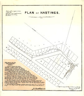
Item is a partial sectional map of Hastings Townsite showing streets, railways, legal addresses, some lot sizes, and municipal boundaries. Item has been annotated with information regarding property ownership, including identification of properties included in a 1919 tax sale, and various symbols of unspecified meaning.