Harrison Lake (B.C.)

Taxonomy

Code

Scope note(s)

Source note(s)

Display note(s)

Hierarchical terms

Harrison Lake (B.C.)

Equivalent terms

Harrison Lake (B.C.)

Associated terms

Harrison Lake (B.C.)

6 Archival description results for Harrison Lake (B.C.)

6 results directly related Exclude narrower terms

Chehalis River and Harrison Lake

Item is a map sheet containing draft or preliminary versions of maps of the Chehalis River and Harrison Lake, relating to surveys conducted by H. Idsardi.

Plan shewing road traverse & levels from Agassiz to Harrison Lake

Item is a map sheet containing a main map showing the proposed hydro-electric development near Agassiz, B.C., a detail map of the development and two cross-sections of the Harrison River. The map appears to be a preliminary version of MAP 1112, drawn by surveyor H. Idsardi, for the City Engineer's Office to use as the basis for MAP 1112.

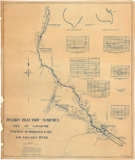
Portion of Harrison Lake and Lillooet River

Item is a map sheet survey data from Lilloet Lake in the north to Harrison Lake in the south. The main map show potential dam sites, water levels, bridges and wagon roads. Significant bodies of water included on the map are Harrison Lake, Little Harrison Lake, Glacier Lake, Fire Lake, Lilloet lake, Little Lillooet or Tenas Lake, and Lillooet River. Also shown are Billy Goat Creek, 25 Mile Creek, Rogers Creek, Gowan Creek, Glacier Creek, Spriny Creek, Tipella Creek, Douglas Creek and 6 1/2 Mile Creek. The sheet includes two nautical charts showing depth soundings at the south end of Lillooet Lake and the south end of Tenas Lake. The six sections show depth measured along points on the Lillooet River.