
Rainbow Falls, Harrison Lake, B.C.
- AM1052-: AM1052 P-1163
- Item
- 1927
42 results directly related Exclude narrower terms
Rainbow Falls, Harrison Lake, B.C.

Part of City of Vancouver Archives sound recording and moving image collection
Item is a film containing part 2 of We Drivers. Film contains footage of North Vancouver, a picnic at Horseshoe Bay, Howe Sound, road from Marine Drive to Grouse Mountain, Grouse Mountain highway and Chalet, the gate to Grouse Mountain; the view from Grouse Mountain, hiking around Grouse Mountain, ferry from North Vancouver to downtown Vancouver, the Vancouver skyline from the Burrard Inlet, a band stand, horse racing at Hastings Park and speed boat racing at Harrison Lake. Produced for Trimble Service Garage.
![Green Point Logging Co. Ltd. ["Climax" type locomotive #2 at camp]](/uploads/r/null/e/f/ef4e5aa00c7c2042872742560cc7df125ce826525eb3efa6178d6790c1066191/0f4447e0-ba09-44e8-8ea2-890746544aec-A01324_142.jpg)
Green Point Logging Co. Ltd. ["Climax" type locomotive #2 at camp]
Part of Stuart Thomson fonds
![Green Point Logging Co. Ltd. [log dump and camp]](/uploads/r/null/c/5/c57454864b763f0a3188bfae58e633e8a6fea63e3a4b9cf0089e4263e490e81b/1ef2ac24-5852-4fe5-9409-c911bbad4c65-A01325_142.jpg)
Green Point Logging Co. Ltd. [log dump and camp]
Part of Stuart Thomson fonds
![Green Point Logging Co. Ltd. [view of lake and log dump]](/uploads/r/null/0/c/0c2b3b3d6e57f7c5a4c1c97dff4dc188c94746d595f37d6c0b3b73fe649ef36b/4a9116d1-89e1-4cce-8940-6faab43b05a8-A01326_142.jpg)
Green Point Logging Co. Ltd. [view of lake and log dump]
Part of Stuart Thomson fonds
![Green Point Logging Co. Ltd. ["Shay" type locomotive at log dump]](/uploads/r/null/a/a/aa6aa96792c82f666bcbed914e4737e92faf11274a34680d3e73fabe547c94af/2a6df0f8-e695-44ae-8bf7-ce5dcec69a9b-A01327_142.jpg)
Green Point Logging Co. Ltd. ["Shay" type locomotive at log dump]
Part of Stuart Thomson fonds

Part of Stuart Thomson fonds
![Green Point Logging Co. Ltd. [trestle with sprinkler system to reduce fire hazard]](/uploads/r/null/7/7/771f3bf5ae454191fd3da9ca62523e790754fcc29db03f13c7b42b1ee0f0f86e/4fe7b97e-69bf-4c71-9a41-4faa7a5a1c8d-A01328_142.jpg)
Green Point Logging Co. Ltd. [trestle with sprinkler system to reduce fire hazard]
Part of Stuart Thomson fonds
![Green Point Logging Co. Ltd. [train on trestle with sprinkler system]](/uploads/r/null/f/2/f2162b752eb9b747a1239e5a42333ce1ef8b3940960b7a1849df227477c0a20e/2cbda9f5-08be-42b2-ac45-804039c144e6-A01329_142.jpg)
Green Point Logging Co. Ltd. [train on trestle with sprinkler system]
Part of Stuart Thomson fonds
![Green Point Logging Co. Ltd. ["Jill-Poke" log unloading devise at log dump]](/uploads/r/null/0/9/092635e4a4564909490d7cee1ec10c25ac27e90b45b44a62682ea9b3be6df16a/92c6d73b-f5ca-4340-b469-74cb1b3e7bb8-A01330_142.jpg)
Green Point Logging Co. Ltd. ["Jill-Poke" log unloading devise at log dump]
Part of Stuart Thomson fonds
![Green Point Logging Co. Ltd. ["Shay" locomotive working at log dump]](/uploads/r/null/c/1/c10c5fd586a626342111fa959535ec6c2d8dad8fb05e2db5888fb176e80d300a/b04305ef-357e-491c-a1da-74b5497a22ff-A01331_142.jpg)
Green Point Logging Co. Ltd. ["Shay" locomotive working at log dump]
Part of Stuart Thomson fonds
![Green Point Logging Co. Ltd. ["Shay" locomotive working at log dump]](/uploads/r/null/f/c/fc8e9ef0696f399c290c6ec8e911eeb700ae734f0742dfe7505b13e07fc46675/41ad5f27-0d3a-4334-a1de-c096b53bb30f-A01332_142.jpg)
Green Point Logging Co. Ltd. ["Shay" locomotive working at log dump]
Part of Stuart Thomson fonds
![Green Point Logging Co. Ltd. [two men sharpening axes]](/uploads/r/null/8/4/84916460c9bf470853b0d20539aa91aa0d9ece667df9f2bf3dff82c3cd7a7790/36803ef0-f9fc-4ae2-ba2a-90164448e8c7-A01333_142.jpg)
Green Point Logging Co. Ltd. [two men sharpening axes]
Part of Stuart Thomson fonds
![Green Point Logging Co. Ltd. [rail speeder at camp]](/uploads/r/null/3/4/3481c446f90e6e4bcf3ff75637b14a361cb02dba2d32f1a6159586c750ef079a/f03126be-147e-4315-836a-7be9e6f5087f-A01334_142.jpg)
Green Point Logging Co. Ltd. [rail speeder at camp]
Part of Stuart Thomson fonds
![Green Point Logging Co. Ltd. [steam donkey]](/uploads/r/null/2/f/2facbd19ecfecaf08dee39860474a2c56d0b0bd5bb7ab46fb27853155bb32b42/b6ea0b0a-311b-4232-9a80-407818fde00c-A01335_142.jpg)
Green Point Logging Co. Ltd. [steam donkey]
Part of Stuart Thomson fonds
![Green Point Logging Co. Ltd. [steam donkey]](/uploads/r/null/6/e/6ec0d06f88e1fce957d0ec0c62b3b4072377691515ccf9d4944c5ef5971c8123/a5e8acbb-d566-436e-8638-ea6e3b8f6043-A01336_142.jpg)
Green Point Logging Co. Ltd. [steam donkey]
Part of Stuart Thomson fonds
![Green Point Logging Co. Ltd. [Spar tree - log loading]](/uploads/r/null/3/f/3fae209f8fac516b86900107108db26ac0d741eae1b839bdbb366011c508302d/e8bc0507-d7fe-48b8-828e-832ba4cfd07d-A01337_142.jpg)
Green Point Logging Co. Ltd. [Spar tree - log loading]
Part of Stuart Thomson fonds
![Green Point Logging Co. Ltd. [Spar tree - log loading]](/uploads/r/null/1/b/1b1dbc7d6c67ac522e848cad32b52dd240cd66cc3f8e0fea1dfc81cd7687c714/6f9d7e7c-8379-48e1-8fda-07d0111d993d-A01338_142.jpg)
Green Point Logging Co. Ltd. [Spar tree - log loading]
Part of Stuart Thomson fonds
![Green Point Logging Co. Ltd. [Spar tree - log loading]](/uploads/r/null/8/8/8842cb457b8518bd3ec8480829fe4dd915e8202f09821f0170a8905a19466c2a/b4c3cd81-b368-4794-8f14-d16de4817fe5-A01339_142.jpg)
Green Point Logging Co. Ltd. [Spar tree - log loading]
Part of Stuart Thomson fonds
![Green Point Logging Co. Ltd. [logger at base of spar tree]](/uploads/r/null/9/b/9b225f58fc00706ff82c8bd22291c4e8fbf83212916bd0130a3ebcdfc64e136c/2c9f0030-16c4-40dc-9593-fb1873db6b08-A01340_142.jpg)
Green Point Logging Co. Ltd. [logger at base of spar tree]
Part of Stuart Thomson fonds
![Green Point Logging Co. Ltd. [spar tree]](/uploads/r/null/9/8/98065b746003ab3d55d7b262827dcff33cd4f16b7b8dbee951241da981313943/907f9a3d-6a38-4da5-80bc-c33e4af4b787-A01341_142.jpg)
Green Point Logging Co. Ltd. [spar tree]
Part of Stuart Thomson fonds
![Green Point Logging Co. Ltd. [graded roadbed into cutting area]](/uploads/r/null/b/9/b94a962e7f7aadac283b7deef1b407821579c6db01554275e01e569746287282/0aee056b-9e4d-43f2-ba56-e51a1af752cb-A01342_142.jpg)
Green Point Logging Co. Ltd. [graded roadbed into cutting area]
Part of Stuart Thomson fonds
![Green Point Logging Co. Ltd. [cutting area]](/uploads/r/null/5/f/5fd2878ed5184455177dc8f5af627465a790372610fc598ec36659f00195ad5d/463d7b65-1227-4f9a-9340-92b6709689d7-A01343_142.jpg)
Green Point Logging Co. Ltd. [cutting area]
Part of Stuart Thomson fonds
![Green Point Logging Co. Ltd. [rail line through cutting area]](/uploads/r/null/b/0/b0664eeffbe8fd91bc6647edc91c9a782da74ac61833970e2c426200619ce5a0/c415ff55-f8da-4ea6-a241-19a39c965033-A01344_142.jpg)
Green Point Logging Co. Ltd. [rail line through cutting area]
Part of Stuart Thomson fonds

Part of Stuart Thomson fonds
![[People exiting ferry wharf, Harrison Lake]](/uploads/r/null/9/d/9d19b05b5ac5810a1ede8d15506d3e583144a679cf0892fd210ec13e9e845f8a/e4ac131a-4a94-4de4-8083-045ae88421dc-A02849_142.jpg)
[People exiting ferry wharf, Harrison Lake]
Photograph shows a man walking up a ramp away from the dock, girl leaning over railway of ramp, and people on the dock in the background.

Part of William Orson Banfield fonds

Part of William Orson Banfield fonds

The clubhouse at Harrison Lake
Part of William Orson Banfield fonds

Part of William Orson Banfield fonds

In Camp on Harrison Lake, B.C.
Part of Major Matthews collection
"Harrison Hot Springs" is written on the side of the tent
![[Speed boats along the Harrison Lake Transport Company boats for hire dock]](/uploads/r/null/1/4/143ffad430c72e509c12128443859e86d0f691b0bfb7e88982c821abefee7fce/4f7285fd-e457-4058-9574-afec46cd2f90-A76050_142.jpg)
[Speed boats along the Harrison Lake Transport Company boats for hire dock]
Part of James Crookall fonds
![[Crews prepare speed boats for race on Harrison Lake]](/uploads/r/null/f/0/f08baf7d9877b7bf438545f5a91543b72c3a7cba767ad2d62a16b8951eedc668/1e7c93a3-0b27-4d55-a35a-709da4dcb1a1-A76051_142.jpg)
[Crews prepare speed boats for race on Harrison Lake]
Part of James Crookall fonds
![[Speed boats racing on Harrison Lake]](/uploads/r/null/c/1/c1e87a66ed5efe3c279260c66bf909b02a1b54df595bd7d5e2f35287c4e6649b/30088c46-4c23-4a8e-a5e7-95487829c303-A76052_142.jpg)
[Speed boats racing on Harrison Lake]
Part of James Crookall fonds
![[Speed boat racing on Harrison Lake]](/uploads/r/null/5/1/51432587aac126b24f3f38ff092d3fac0ab7ea45bc3fb2d4aace89e5bab63d97/165b51a9-1fbe-4f07-beae-5b73260d8df9-A76053_142.jpg)
[Speed boat racing on Harrison Lake]
Part of James Crookall fonds
![[Spectators on dock watching speed boat racing on Harrison Lake]](/uploads/r/null/d/4/d4b8b4e7b65c8a5dce2f416d00b7aa22776f89c4d514aedff0f4966c79b9296a/32160eb3-4556-46eb-8db4-bcc17200c1bd-A76054_142.jpg)
[Spectators on dock watching speed boat racing on Harrison Lake]
Part of James Crookall fonds
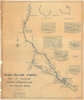
Portion of Harrison Lake and Lillooet River
Part of City of Vancouver fonds
Item is a map sheet survey data from Lilloet Lake in the north to Harrison Lake in the south. The main map show potential dam sites, water levels, bridges and wagon roads. Significant bodies of water included on the map are Harrison Lake, Little Harrison Lake, Glacier Lake, Fire Lake, Lilloet lake, Little Lillooet or Tenas Lake, and Lillooet River. Also shown are Billy Goat Creek, 25 Mile Creek, Rogers Creek, Gowan Creek, Glacier Creek, Spriny Creek, Tipella Creek, Douglas Creek and 6 1/2 Mile Creek. The sheet includes two nautical charts showing depth soundings at the south end of Lillooet Lake and the south end of Tenas Lake. The six sections show depth measured along points on the Lillooet River.

Lower Lillooet River - Harrison Lake to Tipella trail
Part of City of Vancouver fonds

Plan showing road traverse and levels Agassiz to Harrison Lake
Part of City of Vancouver fonds
Item is a map sheet which contains a map of the area around the south end of Harrison Lake. The sheet also includes two cross-sections of the Harrison River and two of the region of the proposed dam site.
Chehalis River and Harrison Lake
Part of City of Vancouver fonds
Item is a map sheet containing draft or preliminary versions of maps of the Chehalis River and Harrison Lake, relating to surveys conducted by H. Idsardi.
Plan of north end of Harrison Lake
Part of City of Vancouver fonds
Part is the verso side of a map sheet, showing a map of a portion of Harrison Lake.
Plan shewing road traverse & levels from Agassiz to Harrison Lake
Part of City of Vancouver fonds
Item is a map sheet containing a main map showing the proposed hydro-electric development near Agassiz, B.C., a detail map of the development and two cross-sections of the Harrison River. The map appears to be a preliminary version of MAP 1112, drawn by surveyor H. Idsardi, for the City Engineer's Office to use as the basis for MAP 1112.