![[Demolition of Immigration Building, 1 of 7]](/uploads/r/null/b/d/b/bdb3fb26781a7240faae659c0870c6380abf526b0734a3209c552ede8aac29be/a67e7d15-cb7a-40b1-9914-aa885ff44a47-CVA1095-15194_142.jpg)
[Demolition of Immigration Building, 1 of 7]
- COV-S644-: CVA 1095-15194
- Item
- [1969?]
Part of City of Vancouver fonds
13 results directly related Exclude narrower terms
[Demolition of Immigration Building, 1 of 7]
Part of City of Vancouver fonds
![[Demolition of Immigration Building, 2 of 7]](/uploads/r/null/1/0/6/1061eb0d8235b3b885b878b25239c486c85cffd30e31b3ff088bc8d69ba28e38/01d98324-d948-4b6f-9dd2-5c2175a2f860-CVA1095-15195_142.jpg)
[Demolition of Immigration Building, 2 of 7]
Part of City of Vancouver fonds
![[Demolition of Immigration Building, 3 of 7]](/uploads/r/null/3/6/1/3613cd74a20f8e8f38e63208e7f3b0c529ccfded59708985f65484cdb5c30fd9/451cc0e3-dfff-461b-98af-c42b4b395faf-CVA1095-15202_142.jpg)
[Demolition of Immigration Building, 3 of 7]
Part of City of Vancouver fonds
![[Demolition of Immigration Building, 4 of 7]](/uploads/r/null/d/6/8/d688877a9ff431f3e9eca012a21d10303470460a9eaa28f682b6134ed9384056/b9f84eec-0ee9-440f-9acb-130ce2e67a19-CVA1095-15203_142.jpg)
[Demolition of Immigration Building, 4 of 7]
Part of City of Vancouver fonds
![[Demolition of Immigration Building, 5 of 7]](/uploads/r/null/7/0/f/70f9928bba8b9e45b73c9d4b6e4c4ddb30ac8af0415090d57d12697f2767cd6d/cced0552-9fc3-4d0e-acf0-2f3fb7ec0448-CVA1095-15204_142.jpg)
[Demolition of Immigration Building, 5 of 7]
Part of City of Vancouver fonds
![[Demolition of Immigration Building, 6 of 7]](/uploads/r/null/1/c/2/1c21bda74ae8923f965de97e1b8bdc4d8fc539962496dd33d6670dd626c50278/6177f21e-81be-4aef-a59a-b01e27bbd3ae-CVA1095-15205_142.jpg)
[Demolition of Immigration Building, 6 of 7]
Part of City of Vancouver fonds
![[Demolition of Immigration Building, 7 of 7]](/uploads/r/null/2/c/2/2c29122425c553f1dea66b8025a96d698bc84f4bbbd76d34c5f4849fb61681c4/16f064b4-e5f0-4af3-a2f1-429a0c5a74bf-CVA1095-15206_142.jpg)
[Demolition of Immigration Building, 7 of 7]
Part of City of Vancouver fonds

Edward VII Fountain on Georgia Street in front of the Court House
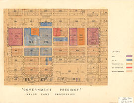
Government precinct : major land ownerships
Part of City of Vancouver fonds
Map is a plan of the area bounded by Oak Street, Broadway, Yukon Street and Sixteenth Avenue, showing streets, blocks, lots and legal descriptions. Map is hand coloured to show property owned by the City, Vancouver General Hospital, the Province of British Columbia, the B.C. Cancer Institute, and private owners within the 'Government Precinct' boundaries. Indicated are the locations of King Edward High School, Vancouver General Hospital, the Model School, Provincial Government building, City Hall, and a Refuge Home. Plan is labelled "G : 1960 March, 320-6A, Gov't Precinct 1957."

Item is a photograph showing the Immigration Building on Vancouver Waterfront.
![[Immigration Building]](/uploads/r/null/6/3/7/637c2fe1e9af665a14ca430bfb250075bc7bbfc9ad294015fd5b7b6b7d34d3c1/6382418a-aa4f-4b0f-8c9d-877966e46abb-CVA1095-15413_142.jpg)
Part of City of Vancouver fonds

Item is a photograph showing the North Facade of the Immigration Building.

Item is a photograph showing City Hall with the coronation medallion of King George VI located below the clock.