
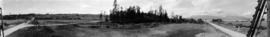
A. Kam on original first tee at Jericho Golf Course
- AM59-F03-: CVA 255-07
- Item
- 1908
Part of Jericho Country Club fonds
174 results directly related Exclude narrower terms
A. Kam on original first tee at Jericho Golf Course
Part of Jericho Country Club fonds

Jericho Club's horse pulling a mower
Part of Jericho Country Club fonds
Item is a photograph showing "Old Tom", the first horse owned by the club and formerly owned by Mr. Dalgleish. The 4th fairway on Imperial Street is in the background.

Man and woman on first green at Jericho Golf Course
Part of Jericho Country Club fonds

Men approaching fourth green with house of J. MacKenzie Bowell under construction in the distance
Part of Jericho Country Club fonds

A. Kam, club professional, on fourth tee
Part of Jericho Country Club fonds
![[Land being cleared for the Shaughnessy Heights Golf Club]](/uploads/r/null/c/f/cfd21ea2d3777879cf1f21ddde4d3f72ea9c19e0afad7558b39aedab6547dce0/6d3cf00d-0514-4067-bec7-eb305ec3696a-A25885_142.jpg)
[Land being cleared for the Shaughnessy Heights Golf Club]
Part of Major Matthews collection

Hollyburn Golf Course, West Vancouver
Part of Major Matthews collection
Photograph shows the clearing for a potential golf course northeast of Marine Drive (Keith Road) and Seventeenth Street (Lawson Avenue)

General view of Burquitlam Golf Links
Part of William Orson Banfield fonds

One of the tees, Burquitlam Golf Club
Part of William Orson Banfield fonds

Club House, Burquitlam Golf Club
Part of William Orson Banfield fonds
![[View of Granville Street and 37th from the 5200 block, Shaughnessy]](/uploads/r/null/4/7/474b6dcf8ef35087ef9b76000cfbe43c23bd03fbd291f22d3ab8f42be1c46994/34a9c2f5-a821-4376-85e7-c727125ccbbb-A63184_142.jpg)
[View of Granville Street and 37th from the 5200 block, Shaughnessy]
Part of Major Matthews collection
Photograph also shows the Shaughnessy Golf Club and Course far right.
Part of Major Matthews collection
Photograph also shows Queen Mary school in the distance.
![[Men playing golf at Hastings Park Golf Links]](/uploads/r/null/2/9/29f921cc89582ad32eeff34e7139a01bf47fc0d0310f8b3b318a8b2d8be333cc/d8f4617e-f907-4d71-8fa6-8cde4c7a0280-A09372_142.jpg)
[Men playing golf at Hastings Park Golf Links]
Part of Major Matthews collection
![[Shaughnessy Golf Links fairway]](/uploads/r/null/2/5/2542348b5679ef2560e33894313187273ac862e96ed53528df5161d5e46a7fc7/148fd6b7-c64b-4d02-8556-9706faa6308d-A09377_142.jpg)
[Shaughnessy Golf Links fairway]
Part of Major Matthews collection
![[Men playing golf at Hastings Park Golf Links]](/uploads/r/null/6/4/648ace08b5e7df9132ba62a483dd79429e3d1d6f7a4feb64ad528ae63e6e3ad6/6faf8004-ffdc-43ce-a7bf-3d4063400c81-A09371_142.jpg)
[Men playing golf at Hastings Park Golf Links]
Part of Major Matthews collection
![[Men playing golf at Shaughnessy Golf Links]](/uploads/r/null/b/1/b11ebd4b18296c330355054fb770add8467e2b8618c639ad27a1394cbbbcf6d7/ab803656-a105-4582-a4e0-5121501c862d-A09375_142.jpg)
[Men playing golf at Shaughnessy Golf Links]
Part of Major Matthews collection
![[Man playing golf at Shaughnessy Golf Links]](/uploads/r/null/e/5/e5ab27386d2175192396454ba885477ce6aac5417744ba6e9f809919ef90aac7/a116d4cf-9121-4c48-ae68-2281ac98f3d3-A09376_142.jpg)
[Man playing golf at Shaughnessy Golf Links]
Part of Major Matthews collection
![[Woman playing golf at Shaughnessy Golf Links]](/uploads/r/null/5/2/52b65cae32419a06b2aba969fbed264594e7bbeed9124465a60b584c831621c1/ee72f45e-c7ad-4a47-8d13-55633915a82f-A09373_142.jpg)
[Woman playing golf at Shaughnessy Golf Links]
Part of Major Matthews collection
![[Woman playing golf at Shaughnessy Golf Links]](/uploads/r/null/b/6/b63922f1d6d5bcc74b9af9bd157207382cb6c45f937aef9c6e44d6d00646df26/7fe95cf0-004e-4707-b720-a4c9d9673aab-A09374_142.jpg)
[Woman playing golf at Shaughnessy Golf Links]
Part of Major Matthews collection
![Layout of golf links for Jericho Country Club addition [Plan of part of lots 176 and 538]](/uploads/r/null/6/5/f/65ff502be40a1bd357c0fc9c7b1cbbaa97321a8b6f801da83ea987d5615e725c/10e28493-c33d-4b6c-8d5f-2d495bccbd0a-LEG1361_142.jpg)
Layout of golf links for Jericho Country Club addition [Plan of part of lots 176 and 538]
Part of Jericho Country Club fonds
Item is a map annotated to show layout of golf links in the area bounded by Imperial Street, Crown Street, English Bay and 10th Avenue. Base map shows streets and lot numbers.

Sheet D : Imperial Street to Trutch Street and Fourth Avenue to Sixteenth Avenue
Part of City of Vancouver fonds
Item is a section showing the area from Imperial Street to Trutch Street and Fourth Avenue to Sixteenth Avenue. Includes streets and roads; blocks; lots and legal descriptions; and parks, schools and golf courses. Section is annotated to show tax sale property for sale, property with no water, street widening and drainage, replotting, reserved land for schools, reserved land for parks, sundry land, capital assets not including schools and parks, schools, and parks, as applicable.
Vancouver (B.C.). Office of the City Engineer

Sheet 11 : Cambie Street to St. George Street and Forty-seventh Avenue to Fifty-eighth Avenue
Part of City of Vancouver fonds
Item is a section showing the area from Cambie Street to St. George Street and Forty-seventh Avenue to Fifty-eighth Avenue. Includes streets, roads, blocks, lots, legal descriptions, golf courses, parks and schools. Map is hand coloured to show tax sale property for sale, property with no water, street widening and drainage, replotting, reserved land for schools, reserved land for parks, sundry land, capital assets not including schools and parks, schools, and parks, as applicable.
Vancouver (B.C.). Office of the City Engineer

Sheet L : Trafalgar Street to Granville Street and Nanton Avenue to Thirty-eighth Avenue
Part of City of Vancouver Archives technical and cartographic drawing collection
Item is a section showing the area from Granville Street to South Cambie Street and Twenty-seventh Avenue to Thirty-eighth Avenue. Includes streets, roads, blocks, lots, legal descriptions, parks, golf courses and schools. Annotations in pencil.
Vancouver (B.C.). Office of the City Engineer

Sheet M : Granville Street to South Cambie Street and Twenty-seventh Avenue to Thirty-eighth Avenue
Part of City of Vancouver Archives technical and cartographic drawing collection
Item is a section showing the area from Granville Street to South Cambie Street and Twenty-seventh Avenue to Thirty-eighth Avenue. Includes streets, roads, blocks, lots, legal descriptions, parks, hospitals, golf courses, reservoirs and government buildings.
Vancouver (B.C.). Office of the City Engineer

Sheet U : Churchill Street to Cambie Street and Forty-ninth Avenue to Park Drive
Part of City of Vancouver Archives technical and cartographic drawing collection
Item is a section showing the area from Churchill Street to Cambie Street and Forty-ninth Avenue to Park Drive. Includes streets, roads, blocks, lots, legal descriptions, parks and golf courses.
Vancouver (B.C.). Office of the City Engineer

Sheet S.V. 4 : Ash Street to St. George Street and Fifty-first Avenue to Sixty-third Avenue
Part of City of Vancouver Archives technical and cartographic drawing collection
Item is a section showing the area from Ash Street to St. George Street and Fifty-first Avenue to Sixty-third Avenue. Includes streets, roads, blocks, lots, legal descriptions, parks, golf courses, hospitals and schools.
Vancouver (B.C.). Office of the City Engineer
![Marine [Drive] Golf and Country Club](/uploads/r/null/2/2/22dd7d67e047d71c0f207458004881b05bf22a940c8bddaaa2db847cb332fbf4/a7febf44-080b-476f-8dcf-0db0ea97ca43-A17196_142.jpg)
Marine [Drive] Golf and Country Club
Part of Stuart Thomson fonds
![[View of the golf course visited by Douglas Haig, 1st Earl Haig (Field Marshal)]](/uploads/r/null/c/6/c65415563a46f76052ddc86e293c78207f18d9431dc67db6b0714850887544a9/deddc0ba-9eee-46a9-9876-09507b71027b-A60899_142.jpg)
[View of the golf course visited by Douglas Haig, 1st Earl Haig (Field Marshal)]
Part of Major Matthews collection
![[Jericho Country Club golf course]](/uploads/r/null/3/8/38ced51a4fbf1e5b37e1dcd0910ebc4e2a37d83b9bebb15cf24687854e2d0c87/d3e83ad2-27ae-4253-bd1c-6669bf851dc3-A25946_142.jpg)
[Jericho Country Club golf course]
Part of Major Matthews collection

Part of William Orson Banfield fonds

Sheet M : Granville Street to Kersland Drive and Twenty-seventh Avenue to Thirty-eighth Avenue
Part of City of Vancouver fonds
Item is a section showing the area from Granville Street to Kersland Drive and Twenty-seventh Avenue to Thirty-eighth Avenue. Includes streets and roads; blocks, lots and legal descriptions; and golf courses, parks and government buildings. The map is hand coloured to show tax sale property for sale, property with no water, street widening and drainage, replotting, reserved land for schools, reserved land for parks, sundry land, capital assets not including schools and parks, schools, and parks, as applicable.

Sheet H : Alexandra Street to Cambie Street and Fifteenth Avenue to Twenty-seventh Avenue
Part of City of Vancouver Archives technical and cartographic drawing collection
Item is a section showing the area from Alexandra Street to Cambie Street and Fifteenth Avenue to Twenty-seventh Avenue.Includes streets and roads; blocks, lots and legal descriptions; as well as parks, schools, hospitals and golf courses.
Vancouver (B.C.). Office of the City Engineer

Sheet S.V. 3 : Cambie Street to Prince Edward Street and Thirty-ninth Avenue to Fiftieth Avenue
Part of City of Vancouver Archives technical and cartographic drawing collection
Item is a section showing the area from Cambie Street to Prince Edward Street and Thirty-ninth Avenue to Fiftieth Avenue. Map shows streets, roads, blocks, lots and legal descriptions, and the locations of parks, schools, golf courses and Mountainview Cemetery.
Vancouver (B.C.). Office of the City Engineer

Sheet P : Trafalgar Street to Granville Street and Thirty-ninth Avenue to Forty-ninth Street
Part of City of Vancouver Archives technical and cartographic drawing collection
Item is a section showing the area from Trafalgar Street to Granville Street and Thirty-ninth Avenue to Forty-ninth Street. Includes streets, roads, blocks, lots, legal descriptions, parks, golf courses, schools and community centres. Annotations in red pencil.
Vancouver (B.C.). Office of the City Engineer

Sheet S : Musqueam Reserve to Macdonald Street and Forty-ninth Avenue to Fraser River
Part of City of Vancouver Archives technical and cartographic drawing collection
Item is a section showing the area from the Musqueam Reserve to Macdonald Street and Forty-ninth Avenue to Fraser River. Includes streets, roads, blocks, lots, and legal descriptions. Map indicates the locations of the Point Grey Golf and Country Club and the Celtic Cannery. Annotations in red ink.
Vancouver (B.C.). Office of the City Engineer

Sheet L : Trafalgar Street to Granville Street and Nanton Avenue to Thirty-eighth Avenue
Part of City of Vancouver fonds
Item is a section showing the area from Trafalgar Street to Granville Street and Nanton Avenue to Thirty-eighth Avenue. Includes streets, roads and sewers; blocks, lots and legal descriptions; and parks, golf courses and schools. The map is hand coloured to show tax sale property for sale, property with no water, street widening and drainage, replotting, reserved land for schools, reserved land for parks, sundry land, capital assets not including schools and parks, schools, and parks, as applicable.
Vancouver (B.C.). Office of the City Engineer

Sheet 17 : Argyle Street to Vivian Street and Sixty-second Avenue to Kent Street
Part of City of Vancouver fonds
Item is a section showing the area from Argyle Street to Vivian Street and Sixty-second Avenue to Kent Street. Includes streets, roads, blocks, lots, legal descriptions and golf courses. Map is hand coloured to show tax sale property for sale, property with no water, street widening and drainage, replotting, reserved land for schools, reserved land for parks, sundry land, capital assets not including schools and parks, schools, and parks, as applicable. "22, 23, 25 to 33, 35, 36/258-329" is written in ink at the top of the map.
Vancouver (B.C.). Office of the City Engineer

Sheet W : Fraser River to French Street and Fifty-ninth Avenue to Seventy-first Avenue
Part of City of Vancouver fonds
Item is a section showing the area from Fraser River to French Street and Fifty-ninth Avenue to Seventy-first Avenue. Includes streets and roads; blocks, lots and legal descriptions; and parks and golf courses. Map is hand coloured to show tax sale property for sale, property with no water, street widening and drainage, replotting, reserved land for schools, reserved land for parks, sundry land, capital assets not including schools and parks, schools, and parks, as applicable.
Vancouver (B.C.). Office of the City Engineer
Sheet 18 : Vivian Street to Boundary Road and Sixty-fifth Avenue to Fraser River
Part of City of Vancouver fonds
Item is a section showing the area from Vivian Street to Boundary Road and Sixty-fifth Avenue to Fraser River. Includes streets, roads and railway lines; blocks, lots and legal descriptions; and parks, schools and golf courses. Map is hand coloured to show tax sale property for sale, property with no water, street widening and drainage, replotting, reserved land for schools, reserved land for parks, sundry land, capital assets not including schools and parks, schools, and parks, as applicable.
Vancouver (B.C.). Office of the City Engineer

Sheet G : Trafalgar Street to Granville Street and Sixteenth Avenue to Nanton Avenue
Part of City of Vancouver Archives technical and cartographic drawing collection
Item is a section showing the area from Trafalgar Street to Granville Street and Sixteenth Avenue to Nanton Avenue. Includes streets and roads; blocks, lots and legal descriptions; and parks, schools, railway lines and golf courses.
Vancouver (B.C.). Office of the City Engineer

Sheet O : Holland Street to Elm Street and Thirty-eighth Avenue to Forty-ninth Avenue
Part of City of Vancouver Archives technical and cartographic drawing collection
Item is a section showing the area from Holland Street to Elm Street and Thirty-eighth Avenue to Forty-ninth Avenue. Includes streets, roads, blocks, lots, legal descriptions, parks, golf courses and schools. Annotations in ink and pencil.
Vancouver (B.C.). Office of the City Engineer

Sheet Q : Churchill Street to Cambie Street and Thirty-eighth Street to Forty-ninth Avenue
Part of City of Vancouver Archives technical and cartographic drawing collection
Item is a section showing the area from Churchill Street to Cambie Street and Thirty-eighth Street to Forty-ninth Avenue. Includes streets, roads, blocks, lots, legal descriptions, parks, golf courses and schools. Annotations in pencil.
Vancouver (B.C.). Office of the City Engineer

Sheet T : Larch Street to Granville Street and Forty-ninth Avenue to Sixty-first Avenue
Part of City of Vancouver Archives technical and cartographic drawing collection
Item is a section showing the area from Larch Street to Granville Street and Forty-ninth Avenue to Sixty-first Avenue. Includes streets, roads, blocks, lots, legal descriptions, parks and golf courses.
Vancouver (B.C.). Office of the City Engineer

Sheet W : Fraser River to French Street and Fifty-ninth Avenue to Seventy-first Avenue
Part of City of Vancouver Archives technical and cartographic drawing collection
Item is a section showing the area from the Fraser River to French Street and Fifty-ninth Avenue to Seventy-first Avenue. Includes streets, roads, blocks, lots, legal descriptions, parks and golf courses.
Vancouver (B.C.). Office of the City Engineer

Sheet S.V. 12 : Fleming Street to Raleigh Street and Forty-eighth Avenue to Newport Avenue
Part of City of Vancouver Archives technical and cartographic drawing collection
Item is a section showing the area from Fleming Street to Raleigh Street and Forty-eighth Avenue to Newport Avenue. Includes streets, roads, blocks, lots, legal descriptions, parks, golf courses and schools. Annotations in pencil.
Vancouver (B.C.). Office of the City Engineer
![[Gleneagles Golf Course]](/uploads/r/null/d/4/d4d0e1fc68956df6eb61f767b03682c6bac7a324c42e60874f1d8e798ed15a45/ce4075ce-a8a5-413f-8374-b5cc0a6dd604-A09910_142.jpg)
Part of Major Matthews collection
Photograph shows area formerly part of Larson's Ranch.
![[Gleneagles Golf Course]](/uploads/r/null/1/4/14100a99e68e215d338cc12150f205f07a2cad5868207eabf19489a1651d3bc9/ca2ec0e2-b6a9-42d7-9618-fba456865755-A09909_142.jpg)
Part of Major Matthews collection
Photograph shows area, formerly part of Larson's Ranch.
![[Gleneagles Golf Course]](/uploads/r/null/1/2/12ebefdb7f5bd57b61da8b13d47ca1da9def9b8f25612b08899e400270f33953/d6a75ed1-ebd5-4f7e-bd3d-47cf674385ed-A09912_142.jpg)
Part of Major Matthews collection

Mrs. Hamber - Golf - Del Monte
Part of Hamber family fonds
Item is an amateur film documenting Mrs. E. W. Hamber playing golf at the Del Monte golf course.
![[Gleneagles Golf Course]](/uploads/r/null/8/0/80a93a183abeefe836fb487a95e23a7d11e83e6d9916ec202730c979832e13f9/278a3065-9bb9-450e-ba09-2c2fc0e42828-A09908_142.jpg)
Part of Major Matthews collection
Photograph shows area, formerly part of Larson's Ranch