- All
- Fraser River (B.C.), 3 results
- Vancouver (B.C.), 1 results
- North Vancouver (B.C.), 1 results
- New Westminster (B.C.), 1 results
- Nanaimo (B.C.), 1 results
- Vancouver Island (B.C.), 1 results
- Burrard Inlet (B.C.), 1 results
- Grouse Mountain (B.C.), 1 results
- Greater Vancouver (B.C.), 1 results
- Stanley Park (Vancouver, B.C.), 1 results
Geology
Taxonomy
Code
Scope note(s)
Source note(s)
Display note(s)
Hierarchical terms
Geology
Equivalent terms
Geology
Associated terms
Geology
17 Archival description results for Geology
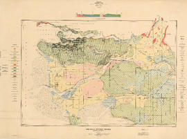
Fraser River Delta, British Columbia
- AM1594-: MAP 31
- Item
- 1923
Part of City of Vancouver Archives technical and cartographic drawing collection
Item is a geological and topographic map covering the area of the Fraser River delta and most of the Greater Vancouver area. Map shows age and content of surface deposits; bedrock outcroppings, marshes, streams, banks and other geological features of the area; oil and gas wells and proposed drilling sites; and city streets, railways, bridges, and other built features. Includes a profile corresponding to two sections on the map: Ambleside to Vanier Park and Burrard Inlet at Burnaby Mountain to just south of the Brunette River.
Fraser River Delta, British Columbia
- AM1594-: MAP 449
- Item
- 1923
Part of City of Vancouver Archives technical and cartographic drawing collection
Item is a map with section showing the geology and topography of the Fraser River Delta region. The map depicts surface deposits and bedrock outcrops over different periods of time. Oil and gas well locations are also included.
Fraser River investigation maps and diagrams
- AM256-S2-1-MAP 620
- File
- 1921
Part of Harry Patten Archibald fonds
File consists of a group of maps and charts of associated data from the Fraser River Investigation by the Geological Survey of Canada.

Geological map of parts of Nanaimo and New Westminster mining divisions
- AM1594-: MAP 240
- Item
- 1908
Part of City of Vancouver Archives technical and cartographic drawing collection
Item is a map showing Tertiary, Mesozoic, and Paleozoic areas and includes descriptive notes. Map drawn "To illustrate report by O. E. Leroy, M. Sc., 1906."
Geological survey. Summary report Annual.
- QE 185 .S7
- 1921
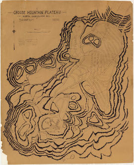
Grouse Mountain Plateau, North Vancouver, B.C.
- AM1594-: MAP 153
- Item
- [ca. 1925]
Part of City of Vancouver Archives technical and cartographic drawing collection
Item is a topographic map showing the contours of Grouse Mountain Plateau, and various lakes, ponds, and creeks, and industrial developments including parking roads, parking areas, bridges, and scenic trails.

- AM1553-8-S4-: MI-475
- Item
- [1994]
Part of Yaletown Productions Inc. fonds
Item is camera original raw footage for "Curse of the Lost Gold Mine." Includes an interview with John F. H. Thompson, a geologist at UBC, who talks about the geology of Pitt Lake, shots of a map of Pitt Lake and Michael Collier plotting out a route on the map, also includes an interview with Mike Boileau, who has been looking into finding gold in the Pitt Lake area since 1979, he talks about the curse, the stories of Pitt Lake, and his own experiences at Pitt Lake.

North America - West Coast. British Columbia. Burrard Inlet
- AM1594-: MAP 673
- Item
- 1893
Part of City of Vancouver Archives technical and cartographic drawing collection
Item is a map sheet containing four nautical charts and one illustration. The main chart depicts Burrard Inlet; the three inset charts depict First Narrows, Vancouver Harbour and Second Narrows. The charts depict soundings and physical features. The illustration is of Point Atkinson Lighthouse.
![Red Dog [Mine] - A world of opportunities](/uploads/r/null/1/2/1229407/ed8f2a20-b365-47c5-b45f-85d525eb21f1-MI-369_142.jpg)
Red Dog [Mine] - A world of opportunities
- AM1553-8-S12-: MI-369
- Item
- [1990]
Part of Yaletown Productions Inc. fonds
Item is a spronsored production produced for Teck Comino by Yaletown Productions titled "Red Dog: A world of opportunities." This is the master copy. Video promotes careers at Red Dog Mine, a lead and zinc mine located in Alaska.
Report of Progress for 1842-1884.
- QE 185 .A13
- s.d.
Stanley Park nature and history walk : guide 3 : Seawall west walk : geology
- AM1519-: PAM 1990-45
- Item
- 1990
Includes Stanley Park history.
The Geology of Vancouver and vicinity.
- QE 187 .V1 B9
- 1918
Vancouver geology : a short guide
- QE 187 .V2 E398 1977
- 1977

Vancouver sheet, British Columbia
- AM1594-: MAP 94
- Item
- 1928
Part of City of Vancouver Archives technical and cartographic drawing collection
Item is a map of Vancouver Island and the southwest portion of mainland British Columbia from Bella Coola to Clinton, and south to New Westminster. Map shows geological, land district, and park boundaries; locations of mining recording offices and sub-offices; elevations in feet above sea level; mineral occurrences; and the development of geological formations by era.