- G 620 .B23
- 1818
Geography
Taxonomy
Code
Scope note(s)
Source note(s)
Display note(s)
Hierarchical terms
Geography
Equivalent terms
Geography
Associated terms
Geography
30 Archival description results for Geography
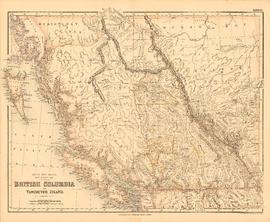
British Columbia and Vancouver Island
- AM1594-: MAP 288
- Item
- [between 1867 and 1884]
Part of City of Vancouver Archives technical and cartographic drawing collection
Item is a map showing the Pacific Coast, Hudson Bay territory, Indian territory, British Columbia, New Caledonia, Russian America, and the north-western United States.
- FC 3806 .A47 1997
- 1997
- FC 3806 .K47 B75 1931
- 1931

- AM1594-: MAP 548
- Item
- Dec. 1, 1834
Part of City of Vancouver Archives technical and cartographic drawing collection
Item is a map depicting the territory that was part of British North America in 1834. The map depicts geographical features, forts and trading posts, factories and cities. The map was compiled from Hudson's Bay Company records of Parry, Franklin, Beechey, and Graab.

- AM1594-: MAP 543
- Item
- 1796
Part of City of Vancouver Archives technical and cartographic drawing collection
Item is a map depicting North America and South America and the boundaries between territories in 1776.
Dictionary of Canadian place names.
- FC 36 .R38 1997
- 1997
Gazetteer of Canada, British Columbia.
- FC 3806 .B75 G38 1953
- 1953
Geographical gazetteer of British Columbia.
- FC 3806 .B75 G45 1930
- 1930
Historical atlas of Canada : Canada's history illustrated with original maps
- G 1116 .S1H39 2002
- 2002

- AM1594-: MAP 170
- Item
- Mar. 31, 1937
Part of City of Vancouver Archives technical and cartographic drawing collection
Item is an administrative map which show the locations of government offices, including: mining recording offices, trading posts, E. & N. Ry. land grants, railways, and highways. Text includes: Adminstration lists (e.g. Supreme Court County Courts, radio stations, Customs and Excise, index of post offices, etc.); Distance tables [for coast, roads, railways, world]; The population of city, district and village municipalities in British Columbia [from the] census, 1931. Map also includes an inset detailing the Strait of Georgia between Victoria and Vancouver.
Namely Vancouver : hidden history of Vancouver place names.
- FC 3847.4 .S59 2001
- 2001
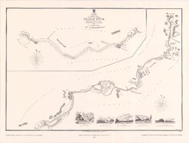
Sketch of the upper part of the Fraser River from Langley to Yale
- AM1594-: MAP 948
- Item
- 1984
Part of City of Vancouver Archives technical and cartographic drawing collection
Item is a modern reproduction of an Admiralty map showing landmarks, geographic features and First Nations settlements along the upper part of the Fraser River from Langley to Yale. The map includes five illustrations of various locations along the river, which correspond to locations noted on the map. The illustrations are labeled: View A - Fort Yale, View B - Emery Bar, View C - Mouth of the Quequealla (Coquihalla River?), View D - Cornish Bar and View M - Entrance of river, Mount Blanchard in the distance.
United Kingdom. Admiralty
Surveys and mapping in British Columbia resources development.
- GA 63 .C3 A5 1954
- 1954
- G 102 .A38 1798
- 1798
- G 1174 .V3 S1 M32 1992 c.2
- 1992
- G 1174 .V3 S1 M32 1992 c.1
- 1992
- G 1174 .V3 S1 M32 1992 c.4
- 1992
- G 1174 .V3 S1 M32 1992 c.3
- 1992