3400 regional series - reference schedule AA - flood plains
- AM1257-S26-F18-35
- File
- [197-]
100 results directly related Exclude narrower terms
3400 regional series - reference schedule AA - flood plains


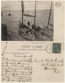
After the night watch, Steveston, B.C.
This postcard includes personal correspondence. Sent to Master Charles Peacock of Hamilton, Ontario.

Anglo-B.C. Packing Co., Part of Evening Catch, Phoenix Cannery, Fraser River
Item is a photograph of men standing amidst their catch at Phoenix Cannery.
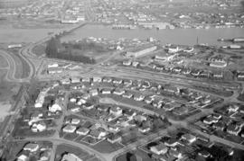
Annacis Industrial Estate : phase no. 2

Boats and logs on Fraser River
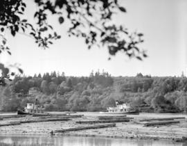
Boats and logs on Fraser River
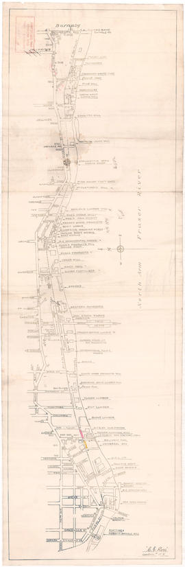
Businesses along the north shore of the North Arm of the Fraser River
Item is a map showing the locations and names of businesses located along the north shore of the North Arm of the Fraser River.
Ross, C.E.
Part of H.A. Price collection
Item is a sectional map showing the Eburne [Marpole] tyo New Westminster branch line of the Vancouver and Lulu Island Railway. The map also shows District Lot lot numbers and names associated with properties adjacent to the line.
Canadian Pacific Railway Company. Engineering Office

Chilliwack Lake scheme & Jones Lake scheme
Part of City of Vancouver fonds
Item is a map depicting proposed hydro-electric development north-west of Chilliwack Lake. The map shows the location so proposed dams, flumes, tunnels and the location of a power house on the Fraser River west of Jones Lake.


Construction site with concrete foundation at the Fraser River
Part of Leopold Bentley family fonds
Item is a photograph showing a construction site with concrete foundation on the Fraser River, possibly near Eburne Sawmills Division at 9149 Hudson Street.

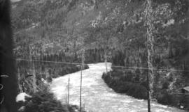
C.P.R.Y., Fraser River, near North Bend, B.C.
Part of Richard H. Trueman fonds

Dock construction at the Fraser River
Part of Leopold Bentley family fonds
Item is a photograph showing dock construction on the Fraser River, possibly near Eburne Sawmills Division at 9149 Hudson Street.

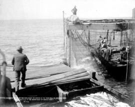
Fisherman emptying salmon from nets

Fishermen and their nets beside dock on the Fraser River
Fishermen and their nets beside dock on the Fraser River

Fishing Fleet at the Mouth of the Fraser River


Foundations and substructure for Port Mann Bridge
Item is an industrial film. Film contains animated graphics and live-action footage showing the construction of seven concrete piers on the Fraser River and shots of bridge site and construction of bridge. The completed Port Mann Bridge is not shown. Film was sponsored by Perini Pacific Ltd. and produced by Lew Weekes.

Part of William Orson Banfield fonds

Fraser River - Annacis Island sheet
Part of City of Vancouver Archives technical and cartographic drawing collection

Fraser River - Deas Island sheet
Part of City of Vancouver Archives technical and cartographic drawing collection

Part of City of Vancouver Archives technical and cartographic drawing collection

Fraser River - New Westminster sheet
Part of City of Vancouver Archives technical and cartographic drawing collection

Fraser River - Port Mann sheet
Part of City of Vancouver Archives technical and cartographic drawing collection

Fraser River - Sand heads sheet
Part of City of Vancouver Archives technical and cartographic drawing collection

Fraser River - Steveston sheet
Part of City of Vancouver Archives technical and cartographic drawing collection

Fraser River - Tilbury Island sheet
Part of City of Vancouver Archives technical and cartographic drawing collection

Fraser River - triangulation control
Part of City of Vancouver Archives technical and cartographic drawing collection
Fraser River and Burrard Inlet
Part of Major Matthews collection

Fraser River and Burrard Inlet
Part of Major Matthews collection
Fraser River and Burrard Inlet
Part of Major Matthews collection

Fraser River and Burrard Inlet
Part of Major Matthews collection
Fraser River and Burrard Inlet
Part of City of Vancouver Archives technical and cartographic drawing collection
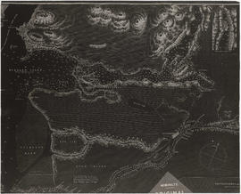
Item is a nautical chart which show details of the area surveyed from Pitt Lake in the north to Roberts Bank in the south and from (what is now) Harrison Hot Springs in the east to Bowen Island in the west. The chart shows soundings in Burrard Inlet, and along the Fraser River.
Fraser River (Bainston Island to Yale) appraisal : waterfront study
Fraser River Delta, British Columbia
Part of City of Vancouver Archives technical and cartographic drawing collection
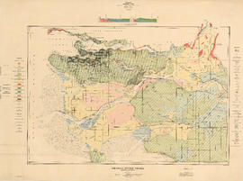
Item is a geological and topographic map covering the area of the Fraser River delta and most of the Greater Vancouver area. Map shows age and content of surface deposits; bedrock outcroppings, marshes, streams, banks and other geological features of the area; oil and gas wells and proposed drilling sites; and city streets, railways, bridges, and other built features. Includes a profile corresponding to two sections on the map: Ambleside to Vanier Park and Burrard Inlet at Burnaby Mountain to just south of the Brunette River.
Fraser River Delta, British Columbia
Part of City of Vancouver Archives technical and cartographic drawing collection
Item is a map with section showing the geology and topography of the Fraser River Delta region. The map depicts surface deposits and bedrock outcrops over different periods of time. Oil and gas well locations are also included.

Fraser River Delta, British Columbia
Part of City of Vancouver Archives technical and cartographic drawing collection
Item is a map of the Fraser River and Lower Mainland showing the following: roads, electric railways and tramways, bridges, churches, schools, post offices, cemeteries, international, municipal, township and city boundaries, wharves, lighthouses, triangulation stations and boundary monuments. Map gives topography of the land and shows water lines, tidal flats and intermittent streams.
Fraser River investigation maps and diagrams
Part of Harry Patten Archibald fonds
File consists of a group of maps and charts of associated data from the Fraser River Investigation by the Geological Survey of Canada.