![[B.C. Electric Railway car repair barn on the Kitsilano Indian Reserve]](/uploads/r/null/9/9/99db416082b7342f19ac662490abc10a00037f0afcdd1a9103d8c31d89f5b446/43783cb7-ea5d-41bd-b349-18cd8fef90a7-A34154_142.jpg)
[B.C. Electric Railway car repair barn on the Kitsilano Indian Reserve]
- AM54-S4-: Park N10.4
- Item
- May 28, 1935
Part of Major Matthews collection
Photograph shows the south end of the Burrard Street Bridge
31 results directly related Exclude narrower terms
[B.C. Electric Railway car repair barn on the Kitsilano Indian Reserve]
Part of Major Matthews collection
Photograph shows the south end of the Burrard Street Bridge
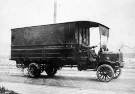
B.C. Electric Railway Co., emergency truck
Item is a photograph of a B.C. Electric Railway Co. emergency truck, a 1910s 3 tonne chain drive Packard truck.

B.C. Electric Railway, Grandview Streetcar #92 and conductors
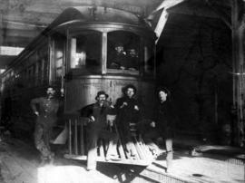
B.C. Electric Railway, interurban streetcar in shop
Item is a photograph of a B.C. Electric Railway Co. interurban streetcar somewhere between Vancouver and New Westminister. Engineers are visible in the cabin, and other railway workers are sitting on and around the pilot.

British Columbia Electric Railway Company Limited : Vancouver Island system and Mainland system
Part of City of Vancouver Archives technical and cartographic drawing collection
Part contains two maps showing city, suburban, and interurban railway lines, transmission lines, generating stations, substations, and transformers.

Canadian Traffic Signal Corporation - Photo of New Signals
Part of Stuart Thomson fonds

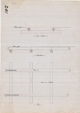
Cross-section, elevation and plan of street railway track
Item shows layout and dimensions of ties, stringers and chair plates.
Cross-section, elevation and plan of street railway track
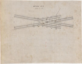
Item shows detail of 20 degree frog (crossing point on railway switch), and has been annotated in pencil with additional measurements.
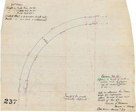
Detail of 90 degree curve for street railway line

Detail shewing rail bond; longitudinal section at joint of rail; cross-section at joint of rail
![Detal [sic] of curves cor [corner]: Cambie and Hastings Sts [Streets]](/uploads/r/null/6/7/9/679b76a1b5a27f1110ac50c4e270e350790002ff202ca525c1a1417a0ed7761e/876c7181-b687-48ff-9fbb-c90a31938202-LEG1360_142.jpg)
Detal [sic] of curves cor [corner]: Cambie and Hastings Sts [Streets]
Item shows street railway lines, various dimensions of ties, number of ties required and number of chairs required.

Enjoyable trips on our interurban lines
Part of City of Vancouver Archives technical and cartographic drawing collection
Part contains text advertising the British Columbia Electric Railway Company's interurban lines.

Greater Vancouver and Fraser Valley
Part of City of Vancouver Archives technical and cartographic drawing collection
Part contains a map showing the B.C. Electric railway line within the Greater Vancouver and Fraser Valley area, other railway lines, main roads, municipal boundaries, industrial sites, airports and ports. An inset map shows the total area served by B.C. Electric within British Columbia and the location of Greater Vancouver and the Fraser Valley within that area.
Part of City of Vancouver Archives sound recording and moving image collection
File contains five films showing some footage from the B.C.E.R. Interurban rail lines including: Oak Street, Burnaby Lake, the Central Park line and the Fairview Belt line. Additionally there is footage showing the Pacific Great Eastern Railway.
Hodgson, Kenneth A.

Lighted journey; the story of the B.C. Electric.
![Plan of curve from Georgia Street to join old track at Stanley Park Br. [Bridge]](/uploads/r/null/7/8/9/78992f176f54403d406f75fbde2782448a524b999882dfcba90b9f2a86ef2c10/18b65040-33d7-4897-a863-cf71e664bf25-LEG1360_142.jpg)
Plan of curve from Georgia Street to join old track at Stanley Park Br. [Bridge]

Plan of Paterson's property, block 364 D.L. 562, City of Vancouver, B.C.
Part of City of Vancouver fonds
Item is a site plan of a lumber yard in the block bounded by Arbutus Street, Tenth Avenue, Yes Street, and Eleventh Avenue. The map shows the location and usage of buildings on the site and the location of the B.C. Electric Railway spur line on the site.
Vancouver (B.C.). Engineer's Office
![Plan of switch point at the junction of Granville and Pender Sts [Streets]](/uploads/r/null/1/2/7/1275d123af0ab9a58981ee7d724cd4def66932ea8eef33853eacd67c70625011/b13b9f5c-027f-415d-b789-360d8aa4f72b-LEG1360_142.jpg)
Plan of switch point at the junction of Granville and Pender Sts [Streets]
Item shows a cross-section of a switch point including weight and dimensions of some parts. An additional drawing shows the location of the switch point in a section of track and additional specifications.

Item is a drawing showing rail switch points, mate points and frog points, locations of spring boxes and wing rails, and distances from various points to one another.
![Plan shewing construction of "The Consolidated Railway and Light Cos [Company's]" track...](/uploads/r/null/e/7/e/e7edb98a12bb5db6f6aa864914a8f45a021db35f677027a5a1dff243a4b403bc/a1e6baeb-fea7-4e86-988c-a1abae0b702e-LEG1360_142.jpg)
Item shows plans, side elevations, and cross-sections of street railway tracks.
Plan showing proposed double tracks Westminster Avenue bridge
Part of City of Vancouver fonds
British Columbia Electric Railway Company

Plan, cross-section and elevation of electric railway line over the Granville Street Bridge

Principal freight railway facilities of British Columbia Hydro and Power Authority
Part of City of Vancouver Archives technical and cartographic drawing collection
Part contains a map showing the B.C. Electric railway (including the Vancouver and Lulu Island branch), other railways, interchange points and municipal city boundaries.

Sheet no. 2 : Vancouver street railway
Item contains four drawings prepared by Garden, Hermon and Burwell showing section, elevation and plan of street railway track and details of joint.

Sketch of 90 degree curve for street railway line at intersection of Granville and Hastings Streets
![Sketch of crossing of C.P.R. [Canadian Pacific Railway] and V.S.R. [Vancouver Street Railway]](/uploads/r/null/3/5/b/35bce59270d0bdf92e20263040c9a55b2ec92102d9c73bf0c3c531eb2ed1f8cd/9d8ef0c7-a9ac-441d-ac37-965b1ad12c20-LEG1360_142.jpg)
Sketch of crossing of C.P.R. [Canadian Pacific Railway] and V.S.R. [Vancouver Street Railway]
![Sketch shewing curves at corner of Cordova and Carrall Sts [Streets]](/uploads/r/null/6/c/7/6c73860a53e0c8cbf7bb6e4460279e41b35fba950ce96ab4a42aa4228a71e04b/7d925a3d-35da-41f8-8074-9626b485ab50-LEG1360_142.jpg)
Sketch shewing curves at corner of Cordova and Carrall Sts [Streets]
![V.S.R. [Vancouver street railway]](/uploads/r/null/f/a/6/fa6e234f1264d13fee820c7cad1e0ab18eacb5b6e521a1766762a531e9263737/25bc6371-9694-444e-b878-ec9de61564d4-LEG1360_142.jpg)
V.S.R. [Vancouver street railway]
Item shows electric railway line curves at intersections of Hastings and Cambie Streets, Powell Street and N. Westminster Avenue (Main Street), Carrall and Cordova Streets, and Cambie and Cordova Streets.