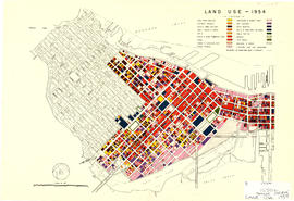
Sectional plan of Vancouver [zoning and land use]
- COV-S167---: LEG1153.456
- Item
- [ca. 1936-ca. 1950]
Part of City of Vancouver fonds
Sectional plan of Vancouver [zoning and land use]
Part of City of Vancouver fonds
Part of City publications collection
Vancouver Downtown South: How close is too close?
Item is a pamphlet discussing proposed building development in downtown.

Proposed industrial subdivision - Joyce and Vanness
Part of City of Vancouver fonds
Part of City publications collection
Item is a map showing land use for single family, two family. and multiple family dwellings, tourist courts and cabins, hotels, offices and other commercial uses, stores, parking and commercial lots, service stations, warehouses and storage yards, light industrial, heavy industrial, public and semi-public buildings, public utilities, schools, open spaces, and railroads and docks.
Vancouver Town Planning Commission display at P.N.E.
Map of Vancouver, British Columbia
Part of City of Vancouver Archives technical and cartographic drawing collection
Map shows city streets, residential, apartment, commercial and industrial districts, "city owned parks and proposed driveways".
Part of City of Vancouver Archives technical and cartographic drawing collection
Item is a map showing zoning in Burnaby according to the following zoning districts: commercial, light industrial, heavy industrial, residential and unzoned. The map also shows streets, railways and municipal boundaries.
Burnaby (B.C.). Town Planning Commission
Plot plan : Sicks' proposed Capilano Stadium at Vancouver, B.C.
Part of City of Vancouver Archives technical and cartographic drawing collection
Item is a drawing with three site plans showing three possible locations for a proposed Capilano Stadium either in or adjacent to Riley Park. The sheet also includes an elevation of the C.P.R. land adjacent to Riley Park.
Sick's Breweries Ltd. (Vancouver, B.C.)
Commercial Map of Greater Vancouver and District [BC]
Part of City of Vancouver Archives technical and cartographic drawing collection
The map shows the Greater Vancouver Area and its roads, streets, and residential, commercial, and industrial districts in July 1924. In accordance with the legend, the map shows railroads, electric railways, parks, and buildings. The map uniquely depicts the center of Vancouver which is approximately 5400 feet and spans from Water and Railway Street to Prior Street and Abbott Street to Princess Street. The center circle then concentrically expands outwards with other circles marking every mile outward.
Additionally, there are annotations in black, red, yellow, and green. The black annotations mark topography and contour lines with listed elevations. The red annotations mark water gauges. The yellow annotations indicate the best routes through the City and District as suggested by the Automobile Club of BC. The green annotations appear for an unknown reason.
The Westernmost road on the map is Marine Drive and the Easternmost is Columbia Street and North Road while the Northernmost road on the map is Dempsey St. in North Vancouver and the Southernmost point is No. 20 Road.
Commercial map of Greater Vancouver and district [planning]
Part of City of Vancouver Archives technical and cartographic drawing collection
Item is a printed map of greater Vancouver which has been used as a base map. The base map appears to be the 1929 version of the Commercial Map of Greater Vancouver and District. On this has been added pasted on pictures, arrows and other material that appears to be related to planning activities of some kind.
Commercial Map of Greater Vancouver and District [BC]
Part of City of Vancouver Archives technical and cartographic drawing collection
Commercial map of Greater Vancouver and District depicts railroads, paved streets, streetcar stops, schools, buildings. Uniquely, the map shows the city divided by Postal Block numbers and half mile circles that radiate from City Hall on the corner of Main and Hastings.
The map has large red arrows and clippings of libraries pasted to it that show six proposed library locations and sketch plans. Also included on the map, is an index of all depicted roads in the Hastings, Point Grey, South Vancouver, and Burnaby areas. A legend and compass rose are located in the bottom left hand corner of the map.
The westernmost is road on the map is Marine Drive and the easternmost is North Road while the northernmost is Dempsey Street, and the southernmost is 20th Road.
Map of Vancouver Unemployment and Relief [BC]
Part of City of Vancouver Archives technical and cartographic drawing collection
The map shows relief and elevations of Vancouver. It depicts streets, parks, and railways, and residential and industrial areas.
The annotations in black ink trace parts of the map: names, railways, and the coast line. The amendments also show Cases and Persons of Domiciled Residents in the Vancouver Area, in May 1934. The map also lists statistics of approximate Cases and Persons of Transient Families and Single Women, and Single Homeless Men.
Pensions and Compensation statistics are also compiled for: Mothers Pensions, Old Age Pensions, War Pensions, amd Workmen's Compensation as of the population of Vancouver in 1931.
The westernmost boundary of the map is Boundary Road and the easternmost boundary is the University of British Columbia while the northernmost is the Burrard Inlet and the southernmost is Sea Island and Lulu Island.

Redevelopment plan for Jericho Department of National Defence lands
Part of City of Vancouver Archives technical and cartographic drawing collection
Item is a map showing proposed redevelopment of portions of former Department of National Defence lands in the Jericho area. The map shows existing city parks, D.N.D. lands to be taken over for parks and recreation, city owned land, single family land, town houses, garden apartments and town houses and proposed new roads. The map appears to have been removed from a report.
Vancouver (B.C.). Engineering Services
A student today, a citizen tomorrow
Part of City publications collection
Plan of Kitsilano Indian Reserve, No. 6 (contours)
Part of City of Vancouver Archives technical and cartographic drawing collection
Item is a topographical map used as a base for showing surveying information such as lot numbers, boundaries, contours, bearings, pipelines, bridge and rail rights-of-way and other landmarks on the Kitsilano Indian Reserve. The map was likely used in planning the development of Vanier Park and/or the Vancouver Museum in the mid-late 1960s. Annotations show "most likely entrance" at McNicoll Avenue.
Vancouver (B.C.). Engineer's Office
![Stanley Park [Golden Jubilee]](/uploads/r/null/2/4/24135e2d726e60ffbc74f0d81c3a53d51a38fe9ea1e86ecda92708249adac23b/1b46df5d-6871-41b2-b1dd-91a0c1d5ad02-MAP624_142.jpg)
Part of City of Vancouver Archives technical and cartographic drawing collection
Item is a copy of a map of Stanley Park which has been extensively annotated to depict plans for addressing traffic, parking and pedestrian regulations for events held in the park during the City's Golden Jubilee celebrations July-Sept. 1936.
Vancouver (B.C.). Board of Park Commissioners

A preliminary proposal for development of Jericho Park
Part of City of Vancouver Archives technical and cartographic drawing collection
Item shows proposed uses for Jericho Park.
![Commercial map of Greater Vancouver and district [assessment districts]](/uploads/r/null/0/9/2/0928add1a06ab55bc236f8bebb87712b7e6ad4422db32cc3065efe7c9da96c04/b5b4129d-f9ba-49b9-a863-2ab6e954897e-MAP102_142.jpg)
Commercial map of Greater Vancouver and district [assessment districts]
Part of City of Vancouver Archives technical and cartographic drawing collection
Item is a printed map of greater Vancouver which has been used as a base map. The base map is the 1924 version of the Commercial Map of Greater Vancouver and District. On this copy has been drawn the boundaries of districts, numbered 1-12; inside the drawn boundaries are each district's area in acrea, population and assessed value of property. While the base map is of the pre-amalgamation municipalities, the assessment districts (?) cover the entire post-amalgamation extent of Vancouver.

City of North Vancouver zone map showing "use" and "set-back" restrictions
Part of City of Vancouver Archives technical and cartographic drawing collection
Item is a map showing zoning in the city of North Vancouver. Zones include residential (single-family residences only, semi-detached residences and apartment blocks, hotels, etc.) business (Local shopping and business and buildings of the warehouse class) and industrial districts.

False Creek development survey occupation plan
Item is a copy of a City of Vancouver Engineer's Office map of the False Creek area from Walnut Street to Main Street and downtown to Sixth Avenue. Map shows streets, railway lines, names of businesses occupying sites on the waterfront, and former high tide waterlines.

False Creek interim harbour headline
Part of City of Vancouver Archives technical and cartographic drawing collection
Map shows interim and ultimate headline, interim headline, ultimate headline, and existing headline, as well as streets, lots, railway yards and waterfront industries in the False Creek area. Map was created for the "False Creek development" study, "Harbour headline" project.
Georgia Viaduct replacement : preliminary engineering study
News #2 [community forum on transportation and planning]
Part of Co-op Radio fonds
Item is an audio reel containing a recording of the Community Forum on Transportation and Planning. Speakers include: Bruce Yorke (COPE), Buster Forester (Hastings Sunrise Senior Citizens Group), Alderman Randall (City of Burnaby), John Farser, Peggy Distefano, Dr. Henry Hightower and Vancouver residents.

Point Grey, B.C. : district map
Part of City of Vancouver Archives technical and cartographic drawing collection
Item is a flyer or promotional brochure showing proposed zoning districts for the municipality of Point Grey to be created by a proposed zoning by-law. The districts are depicted on the map which makes up the majority of the item. Surrounding the map is the text of the proposed by-law.

Preliminary report on civic centre
Part of City publications collection

Part of City publications collection
The future of the Vancouver metropolitan core : draft
Part of City publications collection
Part of City publications collection
Vancouver Monitoring Program information updates
Part of City publications collection
Part of City publications collection
A Plan for the City of Vancouver, British Columbia, including a General Plan of the Region
Part of City publications collection
Part of City publications collection
Part of City publications collection
The document maps and lists the view cones, adopted by the City Council, to protect selected threatened public views.
City Plan : who decides Vancouver's future?
Part of City publications collection
Part of City publications collection
Public meetings : West End planning program
Part of City publications collection
Community visions : Arbutus Ridge/Kerrisdale/Shaughnessy
Part of City publications collection
Community visions : Riley Park/South Cambie
Part of City publications collection
The Vancouver Special [architectural design for houses] : draft
Part of City publications collection
Southeast False Creek : toward a sustainable urban neighbourhood
Part of City publications collection
City of Vancouver : CityFacts 2002 : [web site printout]
Part of City publications collection
Fact sheet contains the following data: population, land area, jobs, office space etc., household size, mother tongues, downtown specifics, etc.
Community Services : Planning : City Plans : [web site printout]
Part of City publications collection
Web pages contain the following sections: "Insights into Population and Housing"; "Insights into Employment"; "Insights into Transportation"; "Insights in[to] the City and Region".
Mount Pleasant Wellness Walkways Design Study report
Part of City publications collection