City planning

Taxonomy

Code

Scope note(s)

Source note(s)

Display note(s)

Hierarchical terms

City planning

Equivalent terms

City planning

  • UF Urban planning

Associated terms

City planning

368 Archival description results for City planning

368 results directly related Exclude narrower terms

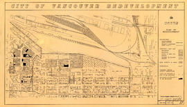
Project 2 : generalized plan of redevelopment

Item is a map showing the boundaries of redevelopment (both "comprehensive" and "limited"), the boundaries of clearance areas for project 1, the boundaries of clearance areas for project 2, the proposed street system and the proposed land use for the city of Vancouver from Burrard Inlet in the north to 16th Avenue in the south and from Nanaimo Street in the east to Arbutus Street in the west.

Project 2 area A-2

Map is a plan for redevelopment project 2, Area A-2, showing the area bound by Clark Drive, Atlantic Street, Main Street and the waterfront. Annotations are undated pencil notations over some of the blocks.

Project 2: identification plan

Item is a map showing city owned property, adjacent lots in same ownership, non-adjacent lots in same ownership, property to be acquired, streets and lanes to be acquired, the boundaries of project 2 clearance, the boundaries of project 1 clearance and the realignment of Raymur Avenue in the area from Railway Street in the north to Atlantic Street in the south and from Clark Drive in the east to Main Steet in the west.

Project 2, area a-2 : condition of buildings

Item is a map showing condition of buildings (ranging from very good to very poor) and sites without buildings in use for storage or parking in the area from Railway Street in the north to Atlantic Street in the south and from Clark Drive in the east to Main Street in the west.

Project 2, area a-2 : proposed property acquisitions project 2

Item is a map showing boundaries of project in area a, property to be acquired, proposed street widening and city owned property included. Annotations show boundaries of project areas, property too be acquired, proposed street widening and properties already owned by the City. Map has been noted as Preliminary.

Project 2, area "h" and part of "b" : condition of buildings

Item is a map showing the conditions of buildings (ranging from very good to very poor) in area "a" and part of area "b" in project 2. The map has been annotated to highlite part of the boundary around sub-area 9, as well as the southern portion of the sub-area. The significance of these annotations is not known.

Project 2, area "h" and part of "b" : plan of redevelopment

Item is a map showing the boundaries of redevelopment areas "b" and "h", the boundaries of project 2 clearance areas 8 and 9, proposed land use, new streets and lanes, easements, sites in project 2 not to be acquired and buildings in project 2 to be retained in the area from Terminal Avenue in the north to Broadway in the south and from Clark Drive in the east to Main Street in the west.

Project 2, part of area "a" : aerial photograph

Item is a map in the form of an aerial photograph, which depicting the part of the city covered by the project: from Railway Street in the north to Prior Street in the south and from Clark Drive in the east to Main Street in the west.

Attached label indicates that the map was approved by Council Sept. 17, 1963.

Project 2, part of area "a" : condition of buildings

Item is a map showing the condition of buildings (ranging from very good to very poor) within the boundaries of project 2, area "a". The map also shows the boundaries of project 2 clearance, the boundaries of project 1 clearance and the realignment of Raymur Avenue.

Project 2, part of area "a" : condition of buildings

Item is a map showing the condition of buildings (ranging from very good to very poor), the boundaries of project 2 clearance, the boundaries of project 1 clearance and the realignment of Raymur Avenue in the area from Burrard Inlet in the north to Atlantic Street in the south and from Clark Drive in the east to Main Street in the west.

Attached label indicates that the map was approved by Council Sept. 17, 1963.

Project 2, part of area "a" : existing utilities, gas, electricity and telephone

Item is a map showing the gas lines, the overhead and underground electricity lines, the overhead and underground telephone lines, the fire alarms underground, the boundaries of project 2 clearance, the boundaries of project 1 clearance and the realignment of Raymur Avenue in the area from Railway Street in the north to Atlantic Street in the south and from Clark Drive in the east to Main Street in the west.

Attached label indicates that the map was approved by Council Sept. 17, 1963.

Project 2, part of area "a" : existing utilities, water and sewer

Item is a map showing the water pipes (10" and over), the sewers (15" and over), the direction of sewer flow, the boundaries of project 2 clearance, the boundaries of project 1 clearance and the realignment of Raymur Avenue in the area from Burrard Inlet in the north to Atlantic Street in the south and from Clark Drive in the east to Main Street in the west.

Attached label indicates that the map was approved by Council Sept. 17, 1963.

Project 2, part of area "a" : identification plan

Item is a map showing city owned property, adjacent lots in same ownership, non-adjacent lots in same ownership, property to be acquired, streets and lanes to be acquired, the boundaries for project 2 clearance, the boundaries for project 1 clearance and the realignment of Raymur Ave for the area from Railway Street in the north to Atlantic Street in the south and from Clarke Drive in the east to Main Street in the west.

Attached label indicates that the map was approved by Council Sept. 17, 1963.

Project 2, part of area "a" : pavements, curbs and sidewalks

Item is a map showing the types of pavement, the curbs and gutters, the sidewalks, the boundaries of project 2 clearance, the boundaries of project 1 clearance and the realignment of Raymur Avenue from Railway Street in the north to Atlantic Street in the south and from Clark Drive in the east to Main Street in the west.

Attached label indicates that the map was approved by Council Sept. 17, 1963.

Project 2, part of area "a" : plan of redevelopment

Item is a map showing the boundaries of clearance areas for projects 1 and 2, the proposed land use (residential, commercial, industrial or school and park sites), the proposed ultimate street system, the new streets and lanes in projects 1 and 2, the easements in projects 1 and 2, the sites in project 2 not to be acquired and the buildings in projects 1 and 2 to be retained.

Project 2, part of area "a" : plan of redevelopment

Item is a map showing the boundaries of clearance areas for projects 1 and 2, the proposed land use (residential, commercial, industrial or school and park sites), the proposed ultimate street system, the new streets and lanes in projects 1 and 2, the easements in projects 1 and 2, the sites in project 2 not to be acquired and the buildings in projects 1 and 2 to be retained in the area from Burrard Inlet in the north to Atlantic Street in the south and from Clark Drive in the east to Main Street in the west.

Attached label indicates that the map was approved by Council Sept. 17, 1963.

Project 2, part of area "a" : utility diversions and rearrangements

Item is a map showing boundaries of clearance areas for project 2 (areas 5 (part), 6 and 7) and project 1 (area 3). Maps also show sewers to remain, sewers to be abandoned, water lines to remain, water lines to be abandoned, gas lines to remain, gas lines to be abandoned, power lines existing underground, proposed diversions of power lines, power lines existing overhead, proposed overhead power lines and long distance telephone lines existing underground. Larger map shows area from Hastings Street in the north to Union Street in the south and from Heatley Avenue in the east to Gore Avenue in the west. Smaller map shows area from Powell Street in the north to Hastings Street in the south and from Clark Drive in the east to Glen Drive in the west. Item also shows estimates of costs for utility diversions and rearrangements for areas 5, 6 and 7.

Attached label indicates that the map was approved by Council Sept. 17, 1963.

Projects no. 1 and 2 maps and plans

File consists primarily of maps pertaining to redevelopment project 1, areas A and D, but also contains two maps from project 2. Maps include identification plans of property to be acquired; boundaries of clearance areas; general and detailed redevelopment plans; and maps showing the layout of existing and proposed utilities.

Proposed zoning : comprehensive redevelopment areas

Item is a map showing proposed zoning for two comprehensive redevelopment areas according to the following district types: residential, commercial (suburban), commercial (medium density), industrial (light) and industrial (heavy). Map also shows the boundaries of the comprehensive redevelopment areas. These two areas lie roughly between Burrard Inlet in the north and 10th Avenue in the south and between Semlin Drive in the east and Burrard Street in the west.

Redevelopment plan for Jericho Department of National Defence lands

Item is a map showing proposed redevelopment of portions of former Department of National Defence lands in the Jericho area. The map shows existing city parks, D.N.D. lands to be taken over for parks and recreation, city owned land, single family land, town houses, garden apartments and town houses and proposed new roads. The map appears to have been removed from a report.

Vancouver (B.C.). Engineering Services

Redevelopment project no. 2 area a-6, including existing blocks 72, 73, 87, 88, D.L. 196 : site plan and general location of utilities plan no. 3

Item is a map created to depict utilities in the proposed project 2 area 6. The map shows fire alarms, sewer lines, water lines, gas lines, underground telephone lines, underground power lines, underground vaults, and curbs. Also noted are existing buildings which may be cleared in future projects, existing buildings in immediate vicinity of area a-6 which may remain, existing subdivisions to be cancelled, easement boundaries, approximate elevations at street intersections, approximate locations at contours and areas for disposal ("private development" and "public housing").

Redevelopment Project No. 2 Plan No. 1

Item is an index plan showing the various area sub-projects for redevelopment project no. 2, and designates comprehensive vs. limited re-development areas. Area A-6 is highlighted in red.

Results 201 to 250 of 368