- AM54-S17-M2185
- File
- Sept. 22, 1953
Part of Major Matthews collection
Part of Major Matthews collection
Departmental Information System Plan (DISP)
Part of City publications collection
[Development control brochures]
Part of City publications collection

Development in the western portion of the Lower Mainland region, 1968
Part of City of Vancouver Archives technical and cartographic drawing collection
Item is a map showing residential, commercial, industrial, civic and institutional, parks and recreational and agricultural zoning in the Lower Mainland area, including West Vancouver, North Vancouver, Vancouver, Burnaby, Coquitlam, New Westminster, Richmond, Maple Ridge, Langley, Surrey, Delta and White Rock. Information has been added to a base map published by the Province of British Columbia.
Development plans and growth trends : City of Vancouver
Part of City publications collection
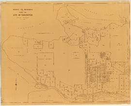
District lot boundaries within the City of Vancouver
Part of City of Vancouver fonds
Item is a program of events for an exhibition of models and illustrations and a series of guest speakers by the Vancouver Town Planning Commission, October 18 to November 10, 1965.
Downtown Vancouver 1955-1976 : City of Vancouver development plan
Part of City publications collection
Dream city : Vancouver and the global imagination
East Vancouver neighbourhoods study report
Part of City publications collection

Part of City publications collection

False Creek development survey occupation plan
Item is a copy of a City of Vancouver Engineer's Office map of the False Creek area from Walnut Street to Main Street and downtown to Sixth Avenue. Map shows streets, railway lines, names of businesses occupying sites on the waterfront, and former high tide waterlines.

False Creek interim harbour headline
Part of City of Vancouver Archives technical and cartographic drawing collection
Map shows interim and ultimate headline, interim headline, ultimate headline, and existing headline, as well as streets, lots, railway yards and waterfront industries in the False Creek area. Map was created for the "False Creek development" study, "Harbour headline" project.
Georgia Street : the paper for beautiful squares
Flyer concerning a vote for the redevelopment of Georgia and Granville.
Georgia Viaduct replacement : preliminary engineering study
Part of City publications collection
Goals for Vancouver : a survey for the Vancouver Planning Commission
Part of City publications collection
Grandview-Woodland : a report on local planning activities
Item includes history of the area and analysis regarding local area planning, produced in conjunction with Venture in Community Collaboration, a 1972 Opportunities for Youth project.
Granville Island : April 1986 plan update

Greater Vancouver, British Columbia : regional major street plan
Part of City of Vancouver Archives technical and cartographic drawing collection
Item is a map which has been removed from a copy of the report "A plan for the City of Vancouver, British Columbia, including Point Grey and South Vancouver and a general plan of the region", commissioned by the Vancouver Town Planning Commission from the planning consultants Harland Bartholomew & Associates.
The map shows existing and proposed additions to the Greater Vancouver major street plan.
Harland Bartholomew and Associates
Greening downtown part 1 : general urban design principles
Part of City publications collection
Greening downtown part 2 : character area guidelines
Part of City publications collection
Greening downtown part 3 : test site studies
Part of City publications collection
Greenways, Public Ways : final report
Part of City publications collection
Guidelines for townhouse and apartment development in RT-2 and RT-2A zoned areas
Part of City publications collection
GULP : Green Urban Land Policy
Item is a study initiated by the Community Planning Association of Canada, B.C. Division and the Real Estate Board of Greater Vancouver.
Help shape your urban landscape
Part of City publications collection
In reference to the proposed amendment to zoning and development by-law #3575
Part of City publications collection
Industrial planning in the lower mainland region
Information and opinions relating to proposed civic centre site, Vancouver, B.C.
Part of City publications collection
Part of City publications collection
Inner city neighbourhood rejuvenation : local transit as a catalyst for infill redevelopment

Part of City of Vancouver fonds
Item is a map prepared as part of the Harbour Headline project of the False Creek Development Study. Map shows existing, interim and ultimate harbour headlines, existing water areas, ownership boundaries, other property lines and lease boundaries in and around False Creek.

Key map showing proposed areas for partial and comprehensive redevelopment
Part of City of Vancouver fonds
Item is a map showing the boundaries of the redevelopment study area, comprehensive redevelopment areas, limited redevelopment areas and the East End study area. The boundary of the study area lies roughly between Burrard Inlet in the north and 33rd Avenue in the south and between Nanaimo Street in the east and Carnarvon Street in the west.
Land development and taxation in a central commercial zone, Vancouver
Land for living : the outlook for residential development in the Lower Mainland : June 1963
Part of City publications collection
Item is a map showing land use for single family, two family. and multiple family dwellings, tourist courts and cabins, hotels, offices and other commercial uses, stores, parking and commercial lots, service stations, warehouses and storage yards, light industrial, heavy industrial, public and semi-public buildings, public utilities, schools, open spaces, and railroads and docks.
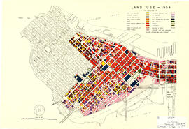
Land use in the City of Vancouver January 1975
Part of City publications collection
![Legend [for colour coding land use]](/uploads/r/null/3/1/2/3120f4f71566883ae774f5f08ae6795bc55fcd40d9f4bdd29f8f25dc782e0a9f/89bc7dbc-376d-43ba-bc88-a0fda629d99a-LEG1153_142.jpg)
Legend [for colour coding land use]
Part of City of Vancouver fonds
Light rapid transit for Greater Vancouver : summary report
Item includes a presentation of concepts, analyses and conclusions regarding a combined downtown and regional transit system.