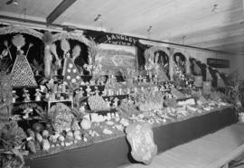
Langley District : exhibit at P.N.E.
- AM1545-S3-: CVA 586-11799
- Item
- Aug. 28, 1948
65 results directly related Exclude narrower terms
Langley District : exhibit at P.N.E.


Urban winter scene, possibly Winnipeg
Part of Hamber family fonds
![Lake of the Woods Milling Co. [Copy of photograph of a town and mills]](/uploads/r/null/0/2/5/025591bf2e1fd47930abc8939098b6243f077f596d5dae1ea9eda1a9c4792a8c/b5336b87-b4fb-40cb-a2b8-3168e806fc6e-CVA99-6570_142.jpg)
Lake of the Woods Milling Co. [Copy of photograph of a town and mills]
Part of Stuart Thomson fonds
![Lake of the Woods Milling Co. [Copy of photograph of a town and mills]](/uploads/r/null/a/6/a/a6a18b2986fe3cf56ca1902c99f6ffc0d7bcec8a02f061be22918f77b1a977d2/832b9d7e-003f-438c-9525-d836765e7b94-CVA99-6569_142.jpg)
Lake of the Woods Milling Co. [Copy of photograph of a town and mills]
Part of Stuart Thomson fonds
Item includes summary report plus recommendations for action.
Vancouver : a brief history of metropolitan Vancouver and its general economy
A tribute to the pioneers of Vancouver "Here before the train", May 23, 1887
Item is a program for a dinner given by the Commissioners of the Park Board at the Stanley Park Pavilion.
The founding of Vancouver, Canada, 1886
The founders of Vancouver, 1886 : our city is their monument
Item is a booklet commemorating the founding of Vancouver, including a chronology of the incorporation process, a brief description of the first election and first council meeting, and a list of the 125 names included on the petition for incorporation. Also includes notes from the seventieth anniversary dinner held at the Stanley Park Pavilion for all surviving pioneers and a list of notable pioneer guests.
Item is an invitation to a celebratory dinner, and includes a short history of L.A. Hamilton's 1885 survey of what would be the streets of Vancouver. Includes a drawing entitled Trail from Granville to Spratt's Oilery, 1883.
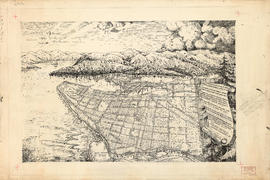
Pictorial map of Greater Vancouver
Part of City of Vancouver Archives technical and cartographic drawing collection
Part contains an illustrated map (not drawn to scale) of Vancouver and the surrounding area and a celebratory poem. An annotation at the edge of the drawing proposes inverting two lines of the poem.

Part of City of Vancouver Archives technical and cartographic drawing collection
Part is an overlay designed to be used with a pictorial map of Greater Vancouver to show key dates in various areas.

Age of buildings : Knight Street to Slocan Street/Wales Street and 22nd Avenue to 37th Avenue
Part of City of Vancouver fonds

Age of buildings : Clark Drive/Knight Street to Slocan Street and 6th Avenue to 22nd Avenue
Part of City of Vancouver fonds

Age of buildings : Clark Drive to Slocan Street and Powell Street/Wall Street to Hastings Street
Part of City of Vancouver fonds
Age of buildings : Wales Street/Vivian Street to Boundary Road and Kingsway to 52nd Avenue
Part of City of Vancouver fonds

Age of buildings : Vivian Street to Boundary Road and 52nd Avenue to S.E. Marine Drive
Part of City of Vancouver fonds
Age of buildings : Clark Drive to Slocan Street and Hastings Street to 6th Avenue
Part of City of Vancouver fonds

Part of City of Vancouver fonds
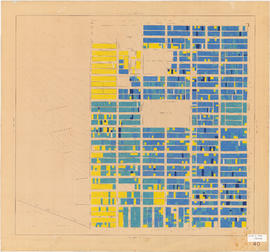
Age of buildings : Oak Street to Main Street and King Edward Avenue to 41st Avenue
Part of City of Vancouver fonds
Age of buildings : Oak Street to Main Street and 6th Avenue/2nd Avenue to Broadway
Part of City of Vancouver fonds
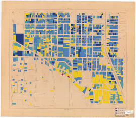
Annotations show date of construction of buildings for the area bounded by Oak Street, Main Street, 6th and 2nd Avenues, and Broadway. Base map extends north to Davie Street at Hornby Street in the northwest and Union Street at Main Street in the northeast. The area extending from Yukon Street to Main Street and 6th Avenue to Broadway is outlined; the significance of the outline is unknown.
Age of buildings : Blanca Street to Discovery Street and 10th Avenue to 16th Avenue
Part of City of Vancouver fonds

Age of buildings : Slocan Street to Boundary Road and 22nd Avenue to Kingsway
Part of City of Vancouver fonds

Age of buildings : University Endowment Lands to Discovery Street and Hadden Avenue to 10th Avenue
Part of City of Vancouver fonds

Age of buildings : Crown Street to Blenheim Street and 41st Avenue to 55th Avenue
Part of City of Vancouver fonds

Age of buildings : Discovery Street to Blenheim Street and Point Grey Road to 10th Avenue
Part of City of Vancouver fonds

Age of buildings : Discovery Street to Blenheim Street and 10th Avenue to King Edward Avenue
Part of City of Vancouver fonds
Age of buildings : Camosun Street to Blenheim Street and King Edward Avenue to 41st Avenue
Part of City of Vancouver fonds
Part of City of Vancouver fonds
Age of buildings : Blenheim Street to Maple Street/Laburnum Street and 41st Avenue to 57th Avenue
Part of City of Vancouver fonds

Age of buildings : Blenheim Street to Maple Street and King Edward Avenue to 41st Avenue
Part of City of Vancouver fonds

Age of buildings : Blenheim Street to Arbutus Street and Broadway to King Edward Avenue
Part of City of Vancouver fonds

Age of buildings : Blenheim Street to Arbutus Street and Point Grey Road to Broadway
Part of City of Vancouver fonds

Age of buildings : Slocan Street to Boundary Road and 5th Avenue to 22nd Avenue
Part of City of Vancouver fonds

Age of buildings : Arbutus Street/S.W. Marine Drive to Fremlin Street and 57th Avenue to 72nd Avenue
Part of City of Vancouver fonds

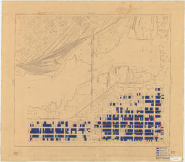
Age of buildings : Granville Street to Fremlin Street and 72nd Avenue to 75th Avenue
Part of City of Vancouver fonds
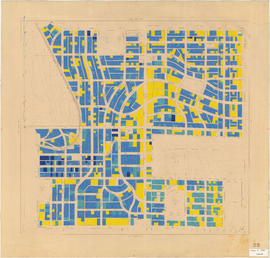
Annotations show date of construction of buildings for the area bounded by Granville Street, Fremlin Street, 72nd Avenue, and 75th Avenue. Base map shows the area bounded by Angus Drive, Cambie Street, 63rd Avenue, and the North Arm of the Fraser River.

Age of buildings : Arbutus Street to Oak Street and Odgen Avenue to Broadway
Part of City of Vancouver fonds
Age of buildings : Arbutus Street to Oak Street and King Edward Avenue to 41st Avenue
Part of City of Vancouver fonds

Age of buildings : Arbutus Street to Oak Street and Broadway to King Edward Avenue
Part of City of Vancouver fonds

Age of buildings : Maple Street to Oak Street and 41st Avenue to 57th Avenue
Part of City of Vancouver fonds

Age of buildings : Oak Street to Main Street and Broadway to King Edward Avenue
Part of City of Vancouver fonds

Age of buildings : Oak Street to Quebec Street and 41st Avenue to 57th Avenue
Part of City of Vancouver fonds

Age of buildings : Fremlin Street to Main Street and 57th Avenue to Kent Avenue
Part of City of Vancouver fonds

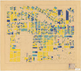
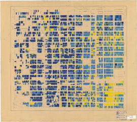
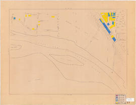
1954 : Age of buildings : Maps 20 and 21 : Downtown and West End
Part of City of Vancouver fonds
Sheet shows date of construction of buildings for the area bounded by Burrard Street, Main Street, Water Street, and the north shore of False Creek. A dotted line runs along a portion of the map, but the significance of the line is unknown.

Age of buildings : Main Street to Knight Street and 57th Avenue to Kent Avenue
Part of City of Vancouver fonds
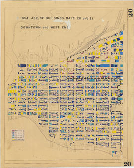
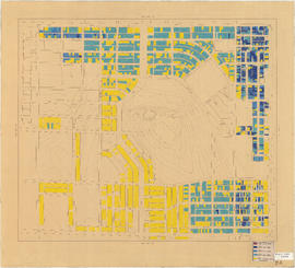
1954 : Age of buildings : Maps 20 and 21 : Downtown and West End
Part of City of Vancouver fonds
Sheet shows date of construction of buildings for the area bounded by Beach Avenue, Hastings Street, Lagoon Drive, and Burrard Street. A dotted line runs along a portion of the map, but the significance of the line is unknown. An annotation at the right edge of the map reads: "other half of "Age of buildings" map."