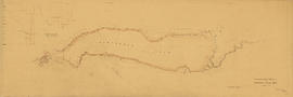
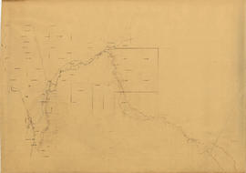
Plan showing preliminary survey of Cheakamus Lake, B.C.
- COV-S346-F01-: MAP 1127
- Item
- Sep. 30, 1923
Part of City of Vancouver fonds
7 results directly related Exclude narrower terms
Plan showing preliminary survey of Cheakamus Lake, B.C.
Part of City of Vancouver fonds
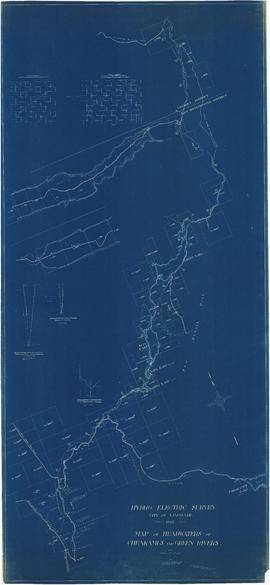
Map of headwaters of Cheakamus and Green rivers
Part of City of Vancouver fonds
Item is a map sheet showing the results of the hydroelectric surveys of the upper Cheakamus River, Green Lake and Green River. The sheet includes 3 cross sections of the Cheakamus River.
Hydro electric survey. Plan showing preliminary survey of Cheakamus Lake
Part of City of Vancouver fonds
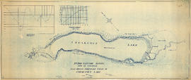
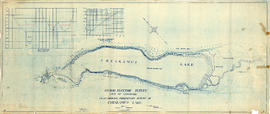
Item is a topographical map showing a preliminary hydro electric survey of Cheakamus Lake, including a capacity diagram of Cheakamus Lake with dam at Section A-B and a cross-section on that line. The sheet includes a graph depicting the capacity of Cheakamus Lake with dam at section A-B. The map includes the Cheakamus River, creeks, characteristics of the terrain, elevations, and water level. Certified correct by Charles W. Williams.
Hydro electric survey. Plan showing preliminary survey of Cheakamus Lake
Part of City of Vancouver fonds
Item is a topographical map showing a preliminary hydro electric survey of Cheakamus Lake, including a capacity diagram of Cheakamus Lake with dam at Section A-B and a cross-section on that line. The sheet includes a graph depicting the capacity of Cheakamus Lake with dam at section A-B. The map includes the Cheakamus River, creeks, characteristics of the terrain, elevations, and water level. Certified correct by Charles W. Williams.
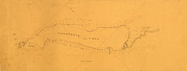
Cheakamus River. Brandywine Creek to Cheakamus Lake
Part of City of Vancouver fonds
Item is a rough preliminary sketch map of part of the Cheakamus River. The map includes notes on terrain, survey data points, the PGE railway right of way, and District Lots.

Part of City of Vancouver fonds
Item is a topographic map of Cheakamus Lake, showing elements of the proposed power infrastructure. The map also includes an inset topographic map of the proposed dam site and a capacity diagram of Cheakamus Lake.
Part of City of Vancouver fonds
Item is a map showing the results of a preliminary survey of Cheakamus Lake and surrounding terrain. This map appears to be a draft of potions of the base map for MAP 1077.01, MAP 1077.02 and MAP 1119.