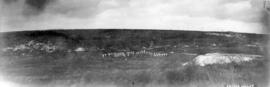
- AM54-S4-: Gr War P7.1
- Item
- [between 1914 and 1918]
Part of Major Matthews collection
Photograph shows Vimy Ridge
178 results directly related Exclude narrower terms
Part of Major Matthews collection
Photograph shows Vimy Ridge
![[Yip Sang grave stone at Mountain View Cemetery]](/uploads/r/null/6/e/6e9b9874fda2df88c89477235d909b26f1dd61cd2248133db7f424f160a7221c/c0f71a3d-0445-4d59-882a-a3d5ab89660a-A72939_142.jpg)
[Yip Sang grave stone at Mountain View Cemetery]
![[Yip Sang grave site at Mountain View Cemetery]](/uploads/r/null/c/5/c5d813de4b421e0ad6df1a0862937c75e4ad5642354b78d5d9983275fa894979/eec6808a-5aec-4a7f-ad69-b90646e1a1eb-A72938_142.jpg)
[Yip Sang grave site at Mountain View Cemetery]
Photograph shows a view of the grave site from a distance.
Where Vancouver sleeps : a commemorative sketch: -1798 -1948
A description of the churchyard belonging to St. Peter's church in Petersham. Includes some information on well-known people buried there, such as Captain George Vancouver.
A description of St. Peter's churchyard in Petersham. Provides information on well-known people buried there, such as Captain George Vancouver.
![[War memorial at] St. John's Cemetery](/uploads/r/null/d/3/d3e110baa6b8a0cb658ea5d2314815024bc4c739b0d21c8085d9a0a30cc75cb3/b3e2a600-feb5-4035-851d-99f167691be8-A04112_142.jpg)
[War memorial at] St. John's Cemetery
Part of Major Matthews collection
J.S. Matthews' notes with print or negative in Archives.
![[View of Mountain View Cemetery looking north from 41st Avenue and showing the Jones addition]](/uploads/r/null/d/7/d70d6a4c26889d22581e1a7e80527e61b112a742324c2c7fe067d98088c178fb/eed968e8-0080-49bc-96f8-8be88b0286b1-A19305_142.jpg)
[View of Mountain View Cemetery looking north from 41st Avenue and showing the Jones addition]
Part of Major Matthews collection
Photograph shows the crematorium.
![[View of graveyard where Captain Vancouver is buried]](/uploads/r/null/f/e/fecc9f7894fefd3ca091e8d6739ee7daf2fd0b6ff09436114c33873876ac45b6/9e7b4ff4-ec36-4acd-b4f2-99056ece7932-A10315_142.jpg)
[View of graveyard where Captain Vancouver is buried]
Part of Major Matthews collection
![[View of gravestones in a Liverpool cemetery]](/uploads/r/null/d/b/dba93cf2cba1fbedd651f6855031584beee0c2f9652f8e3f371b498129003b3b/206efe58-cec2-41d6-8bd5-020b01fe8fb5-A70896_142.jpg)
[View of gravestones in a Liverpool cemetery]
Part of H.A. Price collection
Photograph shows the Price family plot on the far right of the photograph.
![[View of an unidentified graveyard]](/uploads/r/null/d/7/d70669e44260fa49b75a0f58b57243307fa21f9929e2b22145baac0918bdab67/1def7f8f-99d1-48cd-a4c0-769d47a15046-A75651_142.jpg)
[View of an unidentified graveyard]
Part of James Crookall fonds
Vancouver, Cumberland, and Kamloops
Part of Paul Yee fonds
![[Unidentified graveyard]](/uploads/r/null/2/a/2aa79011643549f63f7257cd64913b9cbfd4568a1d20e16e5371ef87070bcc69/3ebc445c-8f34-4a4a-9d8f-ca02c388c9a9-A75639_142.jpg)
Part of James Crookall fonds
Photograph shows the church from CVA 260-619
Thirteenth annual report of the Imperial War Graves Commission
![["The Abbey" mausoleum at Ocean View Cemetery]](/uploads/r/null/f/8/f8126b74ff0daf72b8a1d80db21bc7d527a1b4d767724a41f4998b9bea185773/ec59297e-7c6d-47af-94c3-4ac998d928c0-A09001_142.jpg)
["The Abbey" mausoleum at Ocean View Cemetery]
Part of Major Matthews collection
J.S. Matthews' notes with print or negative in Archives.
![["The Abbey" mausoleum at Ocean View Cemetery]](/uploads/r/null/2/0/201a03cd04a3cae39d75d07fc126fd2b6b57783ee54d86cc061853c028760f1c/08061e6d-6d05-44cb-a16d-07da2a0d26c6-A09000_142.jpg)
["The Abbey" mausoleum at Ocean View Cemetery]
Part of Major Matthews collection
J.S. Matthews' notes with print or negative in Archives.
![["The Abbey" crematorium at Ocean View Cemetery]](/uploads/r/null/d/b/db3280aa3ac00cbf09a6671fb1ca973024ee26f54dc4d65bd2efc7ded9bc6a86/4efb9dba-729b-4149-bec0-579cd1bffd54-A08999_142.jpg)
["The Abbey" crematorium at Ocean View Cemetery]
Part of Major Matthews collection
J.S. Matthews' notes with print or negative in Archives.

Stock, Fraser Canyon, Big Bend Road, Oak Bay, dog's home
Part of City of Vancouver Archives sound recording and moving image collection
Item is a film containing footage of buildings in a small town, close up shots of suited men, forested areas, women in a garden, women walking near shore (probably Oak Bay), dogs playing, picnic in forested area, man on horse, rural town area, Port Hope Tavern, a church, a cemetery and the Big bar ferry.
![[St. Peter's Church yard]](/uploads/r/null/d/4/d467d88928f41fd674ab3bbb18f0f01b7611c144e60c46048ed5f7955f167490/45c648a7-9f76-4496-849f-7500d1aa916d-A63089_142.jpg)
Part of Major Matthews collection
![[St. Peter's Church and graveyard]](/uploads/r/null/8/d/8d9056fba2759154518d81ffc4f6601ba5b7ef860774e650924eb60fb38ef558/dbc2d5d2-6161-4f8c-81f4-44d347ad829d-A37673_142.jpg)
[St. Peter's Church and graveyard]
Part of Major Matthews collection
![[St. Peter's Church]](/uploads/r/null/4/e/4e0426d8f960339ee65010e302c7cb493c591eb20224e6d155a801cd01e1a94f/4dcf4a0a-0b75-4edd-b3d2-1e9707b89df7-A63090_142.jpg)
Part of Major Matthews collection
![Soldiers memorial service, Last Post Association [people placing flowers in cemetery]](/uploads/r/null/c/a/ca63caad924f1f4f12c386a06fbd3918f9f118ab30a4b4d6fbf0918d2e03f08d/9defabaf-bcea-4526-8c7b-1002fe84ba18-A00270_142.jpg)
Soldiers memorial service, Last Post Association [people placing flowers in cemetery]
Part of Stuart Thomson fonds

Sheet S.V. 7 : Prince Edward Street to Argyle Street and Thirty-fifth Avenue to Forty-seventh Avenue
Part of City of Vancouver Archives technical and cartographic drawing collection
Item is a section showing the area from Prince Edward Street to Argyle Street and Thirty-fifth Avenue to Forty-seventh Avenue. Includes streets, roads, blocks, lots, legal descriptions, parks, cemeteries, and schools.
Vancouver (B.C.). Office of the City Engineer

Sheet S.V. 6 : Prince Edward Street to Bruce Street and King Edward to Thirty-fifth Avenue
Part of City of Vancouver Archives technical and cartographic drawing collection
Item is a section showing the area from Prince Edward Street to Bruce Street and King Edward to Thirty-fifth Avenue. Includes streets, roads, blocks, lots, legal descriptions, parks, cemeteries, and schools. Annotations in ink and pencil.
Vancouver (B.C.). Office of the City Engineer

Sheet S.V. 3 : Cambie Street to St. George Street and Twenty-seventh Avenue to Thirty-eighth Avenue
Part of City of Vancouver Archives technical and cartographic drawing collection
Item is a section showing the area from Cambie Street to St. George Street and Twenty-seventh Avenue to Thirty-eighth Avenue. Map shows streets, roads, blocks, lots and legal descriptions and the locations of parks, schools, reservoirs and Mountainview Cemetery.
Vancouver (B.C.). Office of the City Engineer

Sheet S.V. 3 : Cambie Street to Prince Edward Street and Thirty-ninth Avenue to Fiftieth Avenue
Part of City of Vancouver Archives technical and cartographic drawing collection
Item is a section showing the area from Cambie Street to Prince Edward Street and Thirty-ninth Avenue to Fiftieth Avenue. Map shows streets, roads, blocks, lots and legal descriptions, and the locations of parks, schools, golf courses and Mountainview Cemetery.
Vancouver (B.C.). Office of the City Engineer

Sheet S.V. 2 : Cambie Street to St. George Street and Twenty-eighth Avenue to Thirty-eighth Avenue
Part of City of Vancouver Archives technical and cartographic drawing collection
Item is a section showing the area from Cambie Street to St. George Street and Twenty-eighth Avenue to Thirty-eighth Avenue. Map shows streets, roads, blocks, lots and legal descriptions and the locations of parks, schools, reservoirs and Mountainview Cemetery. Annotations in pencil.
Vancouver (B.C.). Office of the City Engineer

Sheet 8 : Prince Edward Street to Bruce Street and Thirty-fifth Avenue to Forty-seventh Avenue
Part of City of Vancouver fonds
Item is a section showing the area from Prince Edward Street to Bruce Street and Thirty-fifth Avenue to Forty-seventh Avenue. Includes streets, roads, blocks, lots, legal descriptions, and cemeteries, parks and schools. Map is hand coloured to show tax sale property for sale, property with no water, street widening and drainage, replotting, reserved land for schools, reserved land for parks, sundry land, capital assets not including schools and parks, schools, and parks, as applicable.
Vancouver (B.C.). Office of the City Engineer

Sheet 8 : Prince Edward Street to Bruce Street and Thirty-fifth Avenue to Forty-seventh Avenue
Part of City of Vancouver Archives technical and cartographic drawing collection
Item is a section showing the area from Prince Edward Street to Bruce Street and Thirty-fifth Avenue to Forty-seventh Avenue. Includes streets, roads, blocks, lots, legal descriptions, and cemeteries, parks and schools.
Vancouver (B.C.). Office of the City Engineer

Sheet 76 : Kerr Street to Mondy Avenue and Asquith Avenue to Forty-ninth Avenue
Part of City of Vancouver Archives technical and cartographic drawing collection
Item is a section showing the area from Kerr Street to Mondy Avenue and Asquith Avenue to Forty-ninth Avenue. Includes streets, blocks, lots and legal descriptions, and the locations of schools, parks and cemeteries.
Vancouver (B.C.). Engineering Services
[Sheet 76 : Kerr Street to Mondy Avenue and Asquith Avenue to Forty-ninth Avenue]
Part of City of Vancouver Archives technical and cartographic drawing collection
Item is a sectional map of a portion of Vancouver showing the area from Kerr Street to Mondy Avenue and Asquith Avenue to Forty-ninth Avenue. Includes streets, blocks, lots and legal descriptions, and the locations of schools, parks and cemeteries.

Sheet 7 : Cambie Street to St. George Street and Thirty-seventh Avenue to Forty-eighth Avenue
Part of City of Vancouver Archives technical and cartographic drawing collection
Item is a section showing the area from Cambie Street to St. George Street and Thirty-seventh Avenue to Forty-eighth Avenue. Includes streets, roads, blocks, lots, legal descriptions, parks, cemeteries, and schools.
Vancouver (B.C.). Office of the City Engineer

Sheet 7 : Cambie Street to St. George Street and Thirty-seventh Avenue to Forty-eighth Avenue
Part of City of Vancouver fonds
Item is a section showing the area from Cambie Street to St. George Street and Thirty-seventh Avenue to Forty-eighth Avenue. Includes streets, roads, blocks, lots, legal descriptions, parks, cemeteries, and schools. Map is hand coloured to show tax sale property for sale, property with no water, street widening and drainage, replotting, reserved land for schools, reserved land for parks, sundry land, capital assets not including schools and parks, schools, and parks, as applicable.
Vancouver (B.C.). Office of the City Engineer

Sheet 59 : Quebec Street to Inverness Street and Forty-seventh Avenue to Thirty-seventh Avenue
Part of City of Vancouver Archives technical and cartographic drawing collection
Item is a section showing the area from Quebec Street to Inverness Street and Forty-seventh Avenue to Thirty-seventh Avenue. Includes streets, blocks, lots and legal descriptions, and the locations of parks, schools and Mountainview Cemetery.
Vancouver (B.C.). Engineering Services
![[Sheet 59 : Quebec Street to Inverness Street and Forty-seventh Avenue to Thirty-seventh Avenue]](/uploads/r/null/0/1/015bc0f349dc1228105d4cdd774354b22820bad860e0a822b707d62c3eb343f5/b9fe9076-66e5-4167-b081-e65e8b625778-MAP339_142.jpg)
[Sheet 59 : Quebec Street to Inverness Street and Forty-seventh Avenue to Thirty-seventh Avenue]
Part of City of Vancouver Archives technical and cartographic drawing collection
Item is a sectional map of a portion of Vancouver showing the area from Quebec Street to Inverness Street and Forty-seventh Avenue to Thirty-seventh Avenue. Includes streets, blocks, lots and legal descriptions, and the locations of parks, schools and Mountainview Cemetery.

Sheet 51 : Ontario Street to Inverness Street and Thirty-seventh Avenue to Twenty-eighth Avenue
Part of City of Vancouver Archives technical and cartographic drawing collection
Item is a section showing the area from Ontario Street to Inverness Street and Thirty-seventh Avenue to Twenty-eighth Avenue. Includes streets, blocks, lots and legal descriptions, and the locations of parks, schools and Mountainview Cemetery.
Vancouver (B.C.). Engineering Services
![[Sheet 51 : Ontario Street to Inverness Street and Thirty-seventh Avenue to Twenty-eighth Avenue]](/uploads/r/null/3/a/3aee300fe6dd39cf02ce71f3cbf8199220cf19dc59148fcf8db71a0bdc7f8239/c1783bd2-c47b-43ed-a71d-29571b121241-MAP339_142.jpg)
[Sheet 51 : Ontario Street to Inverness Street and Thirty-seventh Avenue to Twenty-eighth Avenue]
Part of City of Vancouver Archives technical and cartographic drawing collection
Item is a sectional map of a portion of Vancouver showing the area from Ontario Street to Inverness Street and Thirty-seventh Avenue to Twenty-eighth Avenue. Includes streets, blocks, lots and legal descriptions, and the locations of parks, schools and Mountainview Cemetery.

Sheet 4 : Prince Edward Street to Bruce Street and King Edward Avenue to Thirty-sixth Avenue
Part of City of Vancouver Archives technical and cartographic drawing collection
Item is a section showing the area from Prince Edward Street to Bruce Street and King Edward Avenue to Thirty-sixth Avenue. Map shows streets, roads, blocks, lots and legal descriptions, and the locations of parks, schools and Mountainview Cemetery.
Vancouver (B.C.). Office of the City Engineer

Sheet 4 : Prince Edward Street to Bruce Street and King Edward Avenue to Thirty-sixth Avenue
Part of City of Vancouver fonds
Item is a section showing the area from Prince Edward Street to Bruce Street and King Edward Avenue to Thirty-sixth Avenue. Map shows streets, roads, blocks, lots and legal descriptions, and the locations of parks, schools and Mountainview Cemetery. Map is hand coloured to show tax sale property for sale, property with no water, street widening and drainage, replotting, reserved land for schools, reserved land for parks, sundry land, capital assets not including schools and parks, schools, and parks, as applicable.
Vancouver (B.C.). Office of the City Engineer

Sheet 3 : Cambie Street to St. George Street and Twenty-seventh Avenue to Thirty-eighth Avenue
Part of City of Vancouver fonds
Item is a section showing the area from Cambie Street to St. George Street and Twenty-seventh Avenue to Thirty-eighth Avenue. Map shows streets, roads, blocks, lots and legal descriptions and the locations of parks, schools, reservoirs and Mountainview Cemetery. Map is hand coloured to show tax sale property for sale, property with no water, street widening and drainage, replotting, reserved land for schools, reserved land for parks, sundry land, capital assets not including schools and parks, schools, and parks, as applicable.
Vancouver (B.C.). Office of the City Engineer

Sai Wan Bay War Cemetery, wreath placing ceremony
Item is a photograph of Brigadier Sherwood Lett and General H.D.G. Crerar salute the Canadian flag at a wreath laying ceremony at the flagpole at Sai Wan Bay War Cemetery on the occasion of the Canadian Liaison Mission to Japan's visit to the cemetery during their visit to Hong Kong. The other members of the Mission are visible in the background.

Sai Wan Bay War Cemetery, wreath and Canadian flag
Item is a photograph of a wreath and Canadian flag placed by the Canadian Liaison Mission to Japan on the occasion of their visit to the Sai Wan Bay War Cemetery in Hong Kong.

Sai Wan Bay War Cemetery, overlooking view
Item is a photograph of Sai Wan Bay War Cemetery from the top looking down, taken on the occasion of the Canadian Liaison Mission to Japan's visit to the cemetery while they were in Hong Kong.

Sai Wan Bay War Cemetery, General Crerar placing a wreath
Item is a photograph of General H.D.G. Crerar placing a wreath at a ceremony at the flagpole at Sai Wan Bay War Cemetery on the occasion of the Canadian Liaison Mission to Japan's visit to the cemetery during their visit to Hong Kong. Brigadier Sherwood Lett is visible at the far left and the other members of the Mission are visible in the background.

Sai Wan Bay War Cemetery, General Crerar carrying a wreath
Item is a photograph of General H.D.G. Crerar carrying a wreath on the occasion of the Canadian Liaison Mission to Japan's visit to the Sai Wan Bay War Cemetery in Hong Kong.

Sai Wan Bay War Cemetery, Canadian Liaison Mission to Japan returns from wreath placing
Item is a photograph of the Canadian Liaison Mission to Japan walking up the steps between the graves at Sai Wan Bay War Cemetery after having placed a wreath at the flagpole, visible in the background. Brigadier Sherwood Lett is at the far left and General H.D.G. Crerar leads the group.

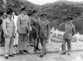
Sai Wan Bay War Cemetery, Canadian Liaison Mission to Japan
Item is a photograph of the Canadian Liaison Mission to Japan walking down the steps between the graves at Sai Wan Bay War Cemetery. General H.D.G. Crerar leads the group, front row left and Brigadier Sherwood Lett is at second row left.
Sai Wan Bay War Cemetery, Canadian Liaison Mission to Japan
Item is a photograph of the Canadian Liaison Mission to Japan at the Sai Wan Bay War Cemetery. Brigadier Sherwood Lett is at the far right and General H.D.G. Crerar is second from right.
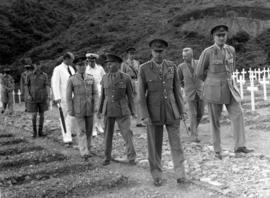
Sai Wan Bay War Cemetery, Canadian Liaison Mission to Japan
Item is a photograph of the Canadian Liaison Mission to Japan walking up the path between the graves at Sai Wan Bay War Cemetery. Brigadier Sherwood Lett is at the fifth from the right and General H.D.G. Crerar leads the group, third from the right.

Sai Wan Bay War Cemetery, Canadian Liaison Mission to Japan
Item is a photograph of the Canadian Liaison Mission to Japan standing between the graves at Sai Wan Bay War Cemetery after having placed a wreath at the flagpole, visible in the background. Brigadier Sherwood Lett is at the far right and General H.D.G. Crerar is the second from the right.