Title and statement of responsibility area
Title proper
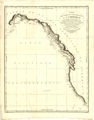
Carte de la parte de la cote nord-ouest de l'Amerique : recconnue pendant les etes de 1792, 1793 and 1794, depuis 29D 54' de Latitude Nord et 244D 33' de Longitude Orientale, jusqu'au Cap Douglas par 58D 52' de Latitude et 207D 20' de Longitude, par le Ca
General material designation
- Cartographic material
Parallel title
Other title information
Title statements of responsibility
ecrit par M. de Blondeau
Title notes
Level of description
Item
Reference code
AM1594-: MAP 1151
Edition area
Edition statement
Edition statement of responsibility
Class of material specific details area
Statement of scale (cartographic)
Scale not determinable
Statement of projection (cartographic)
Statement of coordinates (cartographic)
Statement of scale (architectural)
Issuing jurisdiction and denomination (philatelic)
Dates of creation area
Date(s)
Physical description area
Physical description
1 map : copper plate print ; 84 x 65 cm
Publisher's series area
Title proper of publisher's series
Parallel titles of publisher's series
Other title information of publisher's series
Statement of responsibility relating to publisher's series
Numbering within publisher's series
Note on publisher's series
Archival description area
Custodial history
Scope and content
Map shows the Pacific Coast from Prince William Sound in the north though the Queen Charlotte Islands, Vancouver Island, Port S. Francisco and Sn. Diego to Sn. Domingo in the south.
Notes area
Physical condition
Immediate source of acquisition
Arrangement
Language of material
Script of material
Location of originals
Availability of other formats
Microfiche copy in the Reading Room.
Restrictions on access
Terms governing use, reproduction, and publication
Finding aids
Associated materials
Accruals
Conservation
Restored.
External Link
ftp://webftp.vancouver.ca/archives/MAPS-TIFF/MAP1151.tif
Format: TIFF (LZW compressed)
MD5: D6ADE1B9E9CADE823B9EDC9D608BA67F
*Size: 49915164 bytes
Alternative identifier(s)
Standard number area
Standard number
Access points
Subject access points
Place access points
Name access points
- [s.n.] (Publisher)

