- AM640-S1-: CVA 260-1066
- Item
- [ca. 1918]
Part of James Crookall fonds
272 results directly related Exclude narrower terms
Part of James Crookall fonds
![[Girl standing on rocks, below bridge on the Fraser River]](/uploads/r/null/3/b/3b577c7b026073fceacf9a33802b96557aff043ad60bb820b898dc0007005e93/2da68f37-7b0f-4793-9dd6-9ee8eb54d846-A03877_142.jpg)
[Girl standing on rocks, below bridge on the Fraser River]
![[Grader under a bridge on the Fraser River]](/uploads/r/null/9/8/98eb6fca438deeee26741cdc5e0dce23662a4dec4badaded9dd0e1364ae06fdf/5eb4c9bf-29e3-4edc-b6fa-d95c262339a6-A03878_142.jpg)
[Grader under a bridge on the Fraser River]
![[People on bridge over the Fraser River]](/uploads/r/null/b/2/b2fc435947c0667755df8765e8d8f65230d6d7e86955fafe6f7539bb77d6dd94/efe36ba4-3c1a-4dd6-b6c2-caf6d3331feb-A03879_142.jpg)
[People on bridge over the Fraser River]

Part of Richard H. Trueman fonds

Part of Richard H. Trueman fonds
Image shows C.P.R. line and stone bridge to the left of the canyon.

Lower Kicking Horse Canyon near Golden, B.C.
Part of Richard H. Trueman fonds
Image shows C.P.R. line to the left of the canyon.

Part of Richard H. Trueman fonds

Upper Falls, Kootenay River, B.C.
Part of Richard H. Trueman fonds

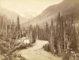
Kicking Horse River, near summit of Rockies
Part of Richard H. Trueman fonds

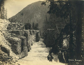
Illecillewaet Canyon, near Revelstoke, B.C.
Part of Richard H. Trueman fonds

Fish Creek Canyon, Cambourne, B.C.
Part of Richard H. Trueman fonds

Illecillewaet River and C.P.R.
Part of Richard H. Trueman fonds

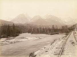
Kicking Horse River and Mt. Stephen, Field, B.C.
Part of Richard H. Trueman fonds

Natural bridge, Kicking Horse River, Field, B.C.
Part of Richard H. Trueman fonds

Kicking Horse River and Mount Stephen, B.C.
Part of Richard H. Trueman fonds
Natural bridge, Kicking Horse River, Field, B.C.
Part of Richard H. Trueman fonds

Illecillewaet Valley from Observation Point, Glacier, B.C.
Part of Richard H. Trueman fonds
![Thompson River from Nicomen [Mountain] looking down 67 miles above Yale](/uploads/r/null/b/4/b4a259f5128b861d7e65e59d707e7e332111f4e3b39837b523d2d908d9362f5f/49bab35b-e81d-46d9-865e-3fc0376674ba-A19696_142.jpg)
Thompson River from Nicomen [Mountain] looking down 67 miles above Yale

Tunnel No. 1 and Yale looking down valley

Tunnels, 11, 12 and 13 looking up river from top of Tunnel No. 10 - 10 3/4 miles above Yale
![Wagon Road looking down [Fraser River]](/uploads/r/null/d/3/d31f33f3f68e921c25dc34269c92a6bbaa05550c337ff84c66b4e5640adc5d0d/6dbaba4f-967d-4271-857e-3299e25f0212-A19680_142.jpg)
Wagon Road looking down [Fraser River]
Suspension bridge from railroad side of river looking up
Photograph shows the Alexandra Bridge
![Lady Franklin Rock [in the Fraser River near Yale]](/uploads/r/null/3/0/30e4a67b983698de8acc03740dd17a80e4f7a567b29da2ea51be9ea5c379c930/ee5161f4-0613-4294-9296-359f4eb8958f-A19670_142.jpg)
Lady Franklin Rock [in the Fraser River near Yale]
Photograph shows a view from the top of the Fraser Canyon

Nicaragua Bluff and wagon road from west side of Fraser River
![Hell's Gate 17 miles above Yale [showing] entrance to Black Canyon](/uploads/r/null/2/7/27c3d0ea7cc412aa5a1d3ee403fda4079147cc4f843c4aa8cb2e8ce431e2e320/b6b5ff03-7f92-4b36-b0df-889321feb06d-A19686_142.jpg)
Hell's Gate 17 miles above Yale [showing] entrance to Black Canyon
Photograph shows fish-drying racks on the rocks beside the river

Black Canyon and railway grade looking down valley from 17th mile post on wagon road
Bluffs, 2 1/2 miles above Yale looking down valley

View toward Lytton from grade 2 miles below
Part of Major Matthews collection
Photograph shows the Fraser River
Part of Major Matthews collection

View from rocks above Fraser Bridge
Part of Major Matthews collection
Photograph shows the Fraser River
![Devil's Gap [and] Beaver Canyon View No. 2](/uploads/r/null/4/4/44d0528e595370f28fc2340079698113fd07efcd4c94dca50739bca01fccf576/c7c99282-4843-4adf-822c-539477e63eb9-A19771_142.jpg)
Devil's Gap [and] Beaver Canyon View No. 2
Part of Major Matthews collection
Photograph shows 5 men standing beside the canyon. The canyon is located in the Selkirk mountain range.
Illecillewaet River and Sir Donald Peak, view at loop
Part of Major Matthews collection
Photograph shows a log cabin under construction
![Stoney Creek [and falls in the Selkirk Mountains]](/uploads/r/null/d/b/dbffd75c29847adc3f153a89d60134cc86fd2c190f11d1aa545d998997e70652/ac0abe89-4308-4e8a-867c-faffb2247c6e-A19750_142.jpg)
Stoney Creek [and falls in the Selkirk Mountains]
Part of Major Matthews collection
Part of Major Matthews collection

Illecillewaet Canyon, near Revelstoke, B.C.
Part of Richard H. Trueman fonds

At the mouth of the Harrison River, B.C.
Part of Major Matthews collection
Photograph shows river and mountains in the distance.

South branch Silver Creek, Harrison Lake, B.C.
Part of Major Matthews collection

Illecillewaet Valley from Look Out on Mount Abbott
Photograph shows two snow sheds and a railroad bridge

Photograph shows members of the Vancouver Natural History Society
![[View of the Marpole rail and highway bridges]](/uploads/r/null/3/9/39d081635b9fd32192951910755276ab7921e8ca55e3206da51189c0b65a8080/015c04a5-11d7-4d15-95ab-e794ef8e9f32-A24442_142.jpg)
[View of the Marpole rail and highway bridges]
Part of Major Matthews collection
Oblique view shows Vancouver International Airport.
![[Capilano River]](/uploads/r/null/b/7/b7be2412e326a0c6f6201ef5cf910c7220fdd88f148b4db420c52812c2073ac7/aefd5b68-5e12-463d-b97c-3b4061d4c1bc-A20100_142.jpg)

Part of Major Matthews collection
![[View of the Oak Street, B.C. Electric and Middle Arm bridges]](/uploads/r/null/8/d/8d4f4dea792a3128229aecfd55a12d3a3432476462ad8cd9991e1ebb16cae075/62c52137-d9af-48bd-a8bc-2a12293b382d-A24441_142.jpg)
[View of the Oak Street, B.C. Electric and Middle Arm bridges]
Part of Major Matthews collection
oblique view
![[View of Oak Street, Marpole rail and highway and Middle Arm bridges]](/uploads/r/null/4/1/4199f99a2a9078cbea68581cb0c930996461009cc1719feede4e449ea5a2379d/94cbe073-4e30-45d0-baea-1b0cb58d69b4-A24443_142.jpg)
[View of Oak Street, Marpole rail and highway and Middle Arm bridges]
Part of Major Matthews collection
Oblique view.
![[Northern view of Oak Street bridge under construction]](/uploads/r/null/3/c/3ce95649becd6661bfb266e929ef9f7f0fb0047a4e0c644d3975486d3b9ddc9c/cf895488-0c64-458d-913c-9deac49a536c-A24440_142.jpg)
[Northern view of Oak Street bridge under construction]
Part of Major Matthews collection
Oblique view shows the Marpole rail and highway bridges.
![[Agassiz-Rosedale Bridge]](/uploads/r/null/b/9/b9a0eb51c46b2d4d18d17731a36fa41612fd8d34f153433851eda3dd6d55e728/ab733b8f-00dc-42e4-bf26-7ef4383180bb-A24439_142.jpg)

Stoney Creek Bridge C.P.R. Selkirks Height 296 feet from below

Surprise Creek Bridge C.P.R. Selkirks Height 157 feet
