![[An unidentified bridge over a river]](/uploads/r/null/3/5/359ccb409adeee9d23fcbcc30e39d276bca490ca280fb5aefbd164cf6535f6f1/92c7dc96-87c6-4988-9b97-0a9910ad7afd-A23365_142.jpg)
[An unidentified bridge over a river]
- AM54-S4-1-S-4-: S-4-84
- Item
- [190-?]
Part of Major Matthews collection
4787 results directly related Exclude narrower terms
[An unidentified bridge over a river]
Part of Major Matthews collection
![[An unidentified river through a canyon]](/uploads/r/null/3/1/3184fc4fc2bfb93733b768ed5c6b7c264c9d580fddd21cc2d22d0b0db6638bfb/04d29994-8ccf-44bd-add0-808e77db3a2d-A23366_142.jpg)
[An unidentified river through a canyon]
Part of Major Matthews collection
![[An unidentified road under construction]](/uploads/r/null/c/1/c114dd4636bac154486b9abfd99501e612ba0b09ba9534479282103e056d45ed/5731fb61-1808-490f-b299-2cd2c7a30d45-A23367_142.jpg)
[An unidentified road under construction]
Part of Major Matthews collection
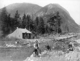
![[An unidentified group standing on a reservoir]](/uploads/r/null/2/f/2fbbb639f64f6c027bd58b826b2d925aa7576f80a3183f95cf23de9868b62f2d/207ab4a3-bd31-4c93-a30e-ee6cb2aae187-A23368_142.jpg)
[An unidentified group standing on a reservoir]
Part of Major Matthews collection
Group portrait
![[An unidentified dam under construction]](/uploads/r/null/7/f/7f1a34d388940bf0c40e25b68575a67d797cf442e5526c55ae91c2cc37e5d738/e7d16baa-6fa5-492e-8df3-04fd627cc8a2-A23369_142.jpg)
[An unidentified dam under construction]
Part of Major Matthews collection
![[View of a man fishing in a river]](/uploads/r/null/1/8/1846bbc11580bc5d45b9b2926cb3ad7e7b305aee44adda27e414ac6d0f016f1f/74f6f85d-67cb-4d10-abda-b2e234b9840b-A23370_142.jpg)
[View of a man fishing in a river]
Part of Major Matthews collection
![[An unidentified dam under construction]](/uploads/r/null/e/3/e35921b56e1824a286b2e6f7ee6a7c8456b923939022f7423a3803475a8812fb/fd18eaaa-12d8-49ae-94bb-d8acb799c4d2-A23371_142.jpg)
[An unidentified dam under construction]
Part of Major Matthews collection
![[An unidentified man sitting on a dock near a ferry]](/uploads/r/null/3/9/39c58e3e3a1b399a7a937ae2f79af73687ca6353fe16a9a8e1d73a927e6ed182/a43617a7-c773-4bf0-93ad-3ba2290877fb-A23372_142.jpg)
[An unidentified man sitting on a dock near a ferry]
Part of Major Matthews collection
![[An unidentified man fishing from a boat in a river]](/uploads/r/null/0/1/0151978564f6d263ad0975063a19c81cdb7f12a401187ee6f8967e0fc2b42783/4c369b24-c0a6-4a93-bae8-33511c331274-A23373_142.jpg)
[An unidentified man fishing from a boat in a river]
Part of Major Matthews collection
Photograph shows Lampert Lum. Co. on the side of the boat
![[Unidentified people standing at the prow of a ship]](/uploads/r/null/4/e/4e1433904f2734464c56fea30f9a0c1084e132d60763bfda31926f77f824567d/c12887ee-ce7b-4944-a6cd-d28269bcde37-A23374_142.jpg)
[Unidentified people standing at the prow of a ship]
Part of Major Matthews collection

Lillooet Lake - Looking up Gold Creek
Part of Major Matthews collection
[possibly Alouette Lake?]
![[A dam under construction]](/uploads/r/null/e/f/ef3f465ae2d6921b4138f996a9872a17e088c7db7e8e8e676f50bc4692ceaa9e/2d1ed9e6-0779-45d5-8b23-62067e447c7a-A23376_142.jpg)
Part of Major Matthews collection
![[A dam under construction]](/uploads/r/null/e/b/eb7be7ba28c2f21880f49c782a527157ed260aa7a9fe40eb866187c4ab0971d2/b85994e0-be03-428e-985a-8678b807fdde-A23377_142.jpg)
Part of Major Matthews collection
![[View of an unidentified sawmill]](/uploads/r/null/a/e/aeba2399827d5f51112abc40cdcb319c6c94eff6db2338c274c2db5aa35099e8/884e43ab-1597-4b6e-9252-8ed972e0b6e1-A23378_142.jpg)
[View of an unidentified sawmill]
Part of Major Matthews collection
![[An unidentified camp in the woods]](/uploads/r/null/e/e/eeea881fd9809175f0723b3063d38b9d82520eb064cf1200b2d4acec5c9f82e2/83c6d51a-a0c6-45f7-aa60-27719ab79d2a-A23282_142.jpg)
[An unidentified camp in the woods]
Part of Major Matthews collection
![[An unidentified man beside a huge tree]](/uploads/r/null/c/7/c7ee7373ed81363e5b595c56e4f48caf6a6a0eb08599dad8055f10283a127c57/86fa0119-086a-4526-bad1-853229053bb4-A23283_142.jpg)
[An unidentified man beside a huge tree]
Part of Major Matthews collection
![[A skid road]](/uploads/r/null/0/2/02d8d65644fd37a3065846332cb751082ea31b3a0093ba112004e0134a38a8a0/db07a69c-7a8f-4783-b3ad-9d08118f9c12-A23284_142.jpg)
Part of Major Matthews collection
[Trips around British Columbia and Washington]

Part of Major Matthews collection

Item is a postcard promoting the chauffeur-driven limousines and charter buses of Classic Limousine Service, a Vancouver-based company

Part of Major Matthews collection
![[Ship docking at wharf - Pender Harbour - Union Steamship Co.]](/uploads/r/null/4/2/425618008e4efb7299c2870f60339c81c383d1885d9b88eb60ad614fd7065cc3/a9d39b1b-a4e5-41f3-a08b-331797367920-A01746_142.jpg)
[Ship docking at wharf - Pender Harbour - Union Steamship Co.]
Part of Stuart Thomson fonds
Item is a photograph showing the vessel, "Lady Cecilia."
H.B. Smith's temporary quarters, 12 miles above Keefers
Part of Major Matthews collection

Workmen improving bluff at "Cariboo Joe's" tunnel, C.P. Ry.
Part of Major Matthews collection
Photograph shows men with loads of rock on tracks next to cliff.

Part of Major Matthews collection
Photograph shows area known as the Big Slide, Kicking Horse River, the slopes of Mt. Field (on right) and Mt. Burgess in the background.

Part of City of Vancouver Archives technical and cartographic drawing collection
Item is a map of southwestern British Columbia from Bute Inlet to Alta Lake and Chilko Lake to northern Gabriola Island showing Crown granted land, surveyed timber leases and licenses, Indian Reserves, government reserves, land district and park boundaries, nautical distances, municipalities, cities and villages, telegraph and telephone lines, pipelines, railways, government agents' offices, mining and sub-mining recording offices, post offices, lighthouses, roads, and elevations of geographical features.
[Construction of Trout (Buntzen) Lake Dam and other photographs]
Part of Major Matthews collection
File consists of an album showing photographs of the construction site at various stages as well as equipment, cabling, rail tracks for transporting material, exterior and interior views of the powerhouse, and views of cleared land for the site and surrounding scenery. Also included are a few photographs of Vancouver and other unidentified locations.
![[The aftermath of a boiler explosion on Vancouver Island]](/uploads/r/null/0/7/070f19c136280230d74baaa6fa4b60faea1c6f47e3ef0aec6305996a7019360d/dda1cb7d-42a4-4498-af29-27d22ed851f0-A63079_142.jpg)
[The aftermath of a boiler explosion on Vancouver Island]
Part of Major Matthews collection
Photograph shows the remains of a boiler on a beach
![[The aftermath of a boiler explosion on Vancouver Island]](/uploads/r/null/6/6/666f307a1d8293f423ca4ccfe0400415f802d6778e3ccf503df6e74e92d573b6/6d011b6b-e5fe-4d2e-8a27-113e88d0a3d7-A63077_142.jpg)
[The aftermath of a boiler explosion on Vancouver Island]
Part of Major Matthews collection
Photograph shows the remains of a boiler on a beach
![[Group of Sikh men in the rain on the waterfront]](/uploads/r/null/1/1/117e2b5fd1f9e916b980cdb08185d47cd69565c4dca347dea2b46407349d4187/e5d9d7e5-b53a-4e8b-aaee-440ff863f2cc-A71517_142.jpg)
[Group of Sikh men in the rain on the waterfront]
Item is a photograph showing a group preparing a cremation.
![[Phillip Sullivan]](/uploads/r/null/2/2/22125fe7e955b8ecc888c2caebc058031383e9c5d422af0de2f9e32d99970f1d/5fb35d4d-7cb1-4940-99b0-8f1b1eed6766-A35099_142.jpg)
Part of Major Matthews collection
![[Women] preparing skins](/uploads/r/null/8/1/81a2a1d13a933a611e658cc0e41bfa8b64cf941479c998ac6187e89e6e16ba49/8d5ed6a5-5f3b-4189-b89e-92e19b12820e-A26492_142.jpg)
Part of Major Matthews collection
Photograph shows two women scraping a moose hide in a frame. Caption found on the front of image: "Squaws preparing skins."
![[Harry James sitting with masks]](/uploads/r/null/3/2/329dd9ff29906224411faac905178dd6efc99be14e70cf3b6a4623988805a9f6/ba0a7f21-585b-427e-98e4-2885b4c8383f-A07367_142.jpg)
[Harry James sitting with masks]
Item is a photograph taken at the Nanaimo Reserve showing Harry James with masks. Inscription on verso of print: "No. 2994 - Indian ceremonial masks are handed down generation to generation. This Indian is nearly 80 years of age and keeps these masks hidden in an old chest in a smoke house on the Reservation. Considerable coaxing was necessary before he would produce them for photographing. It is his belief that if he should lose them a curse would descend upon his family. Don Coltman Photo."
![[Indian salmon temple (shrine)]](/uploads/r/null/f/e/fecd6626fb18b52a314db992557ebe809c446008dd5e83db0c7ab166d158d7b3/87f60b09-afe7-4af4-acc7-ad4afd692819-A26417_142.jpg)
[Indian salmon temple (shrine)]
Part of Major Matthews collection
![[Rev. Charles Montgomery Tate and others]](/uploads/r/null/d/f/dfb1acc2961eeb72d76be6230bd04a65233f1e25bed52ac1b339598d691d6078/b8594018-9752-416b-910b-8dbd51b884dc-A26418_142.jpg)
[Rev. Charles Montgomery Tate and others]
Part of Major Matthews collection
![[Aerial view of] British Pacific Properties [and North Vancouver]](/uploads/r/null/1/4/14644a75d43dd6a85d7a3c082e63134f4994ac268e97d1c0940f786b344bbd7e/46041e12-d683-4b08-81b0-797947030f8f-A23485_142.jpg)
[Aerial view of] British Pacific Properties [and North Vancouver]
Part of Major Matthews collection
Oblique view. Photograph shows Lions Gate (First Narrows) Bridge

Mount Sir Donald from Mount Abbott Glacier National Park
Part of Major Matthews collection