Title and statement of responsibility area
Title proper
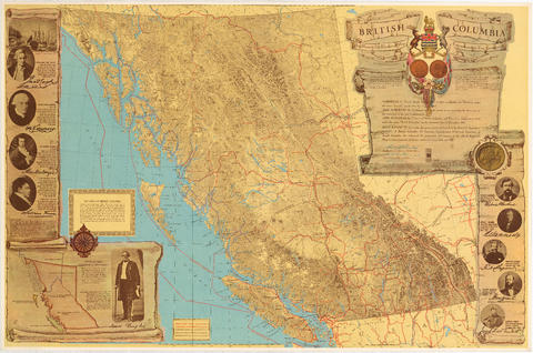
British Columbia : an historical illustrated map commemorating two centenaries, 1867-1967, 1866-1966
General material designation
- Cartographic material
Parallel title
Other title information
Title statements of responsibility
- historical documentation and photographs for this centennial map were compiled through the offices of the Honourable W.D. Black, Provincial Secretary; L.J. Wallace, Deputy Provincial Secretary; and W.E. Ireland, Provincial Librarian and Archivist ;* th
Title notes
Level of description
Item
Reference code
Edition area
Edition statement
Edition statement of responsibility
Class of material specific details area
Statement of scale (cartographic)
Scale not determinable.
Statement of projection (cartographic)
Statement of coordinates (cartographic)
Statement of scale (architectural)
Issuing jurisdiction and denomination (philatelic)
Dates of creation area
Date(s)
-
1966 (Publication)
- Publisher
- Canadian Confederation Centennial Committee of British Columbia
- Place
- s.l.
Physical description area
Physical description
1 map : lithographic print, col., ill. ; 63 x 95 cm
Publisher's series area
Title proper of publisher's series
Parallel titles of publisher's series
Other title information of publisher's series
Statement of responsibility relating to publisher's series
Numbering within publisher's series
Note on publisher's series
Archival description area
Custodial history
Scope and content
Item is an illustrated map is of the province of British Columbia, created to commemorate the Canadian Centennial.
The central component of the sheet is a reproduction of part of a map from the Department of Lands; surrounding the map are illustrations depicting prominent historical figures and accompanying information. The map has been annotated with the routes of Captain Cook's voyage (1778-1779), Captain Vancouver's voyage (1792-1794), and the overland routes of Sir Alexander MacKenzie (1793), David Thompson (1806-1811) and Simon Fraser (1808).
Portraits, accompanied by short biographies, are included for Cook, Vancouver, MacKenzie, Fraser and Sir James Douglas. Six other portraits are of the early governors of the colony of Vancouver Island and of British Columbia between 1849 and 1876. An illustration of the Great Seal of the Realm attached to the royal commission appointing Richard Blanshard the first governor of the colony of Vancouver Island is shown. A short textual description of the birth and expansion of British Columbia is included with an accompanying illustration of the expansion of the province over time.
Notes area
Physical condition
Immediate source of acquisition
Arrangement
Language of material
Script of material
Location of originals
Availability of other formats
A microfilm copy is available in the Reading Room.
Restrictions on access
Terms governing use, reproduction, and publication
Finding aids
Associated materials
Accruals
Conservation
Restored
Rights
Copyright: Milton A. Tisdale; expiry: unknown.
Alternative identifier(s)
Standard number area
Standard number
Access points
Subject access points
Place access points
Name access points
- Canadian Confederation Centennial Committee of British Columbia (Publisher)
- Tisdale, Milton A. (Author)

