![[View from Stanley Park of a] vessel passing under[neath the] Lions Gate [First Narrows] Bridge](/uploads/r/null/8/a/8a60cf3c4bece4b8575e03052e5efc73c170f600fea19e73fa5ad6aef2beb21e/8915f3b2-5b79-4e44-812e-a58388f121bb-A59817_142.jpg)
[View from Stanley Park of a] vessel passing under[neath the] Lions Gate [First Narrows] Bridge
- COV-S511---: CVA 780-795
- Item
- 1967
Part of City of Vancouver fonds
2504 results directly related Exclude narrower terms
[View from Stanley Park of a] vessel passing under[neath the] Lions Gate [First Narrows] Bridge
Part of City of Vancouver fonds
![[View] from train in Rockies [of a train approaching a bridge]](/uploads/r/null/6/f/1/6f139377e2831bc52958f4920ff3134f21f39beb3d1b6e31470bc1a1cb66e5a6/933925a8-5d80-4641-8699-276a2b0839b9-CVA260-1903_142.jpg)
[View] from train in Rockies [of a train approaching a bridge]
Part of James Crookall fonds

View looking east toward Granville Bridge
Part of City of Vancouver fonds
Item is a photograph showing the shoreline underneath the Burrard Bridge and the view looking east toward Granville Bridge; taken from under north end of Burrard Bridge.
![[View looking north along the Granville Bridge towards the Continental Hotel]](/uploads/r/null/9/a/9ad9b43959bfac5892268daa60983d651f1eda935a7f3b64a61e029ce6cb1fbd/4a2fa44c-7f4e-41b9-911d-a15ccf2ac1be-A20303_142.jpg)
[View looking north along the Granville Bridge towards the Continental Hotel]
Part of Major Matthews collection
Photograph shows the shadow of the photographer on the wooden sidewalk, the billboards on the west side of the bridge and a Wild Rose Flour sign on the side of the hotel in the background
![[View looking north from City Hall]](/uploads/r/null/7/a/7a5cefae760823892740b59c0b38bbc5bd3272ce46ad037b620199ee82e0416c/eef32f5c-231c-4970-8973-c3324d2a90d1-A43290_142.jpg)
[View looking north from City Hall]
Part of Major Matthews collection
Photograph shows the Fraser Valley Milk Producers Association (Dairyland) building, the Cambie Bridge, False Creek and Downtown in the background
![[View looking north from False Creek] Photo Taken on June 1st, 1916. Time 1232. Tide 0.4](/uploads/r/null/0/9/097e130b0ecc9fbef37bf311ffdd758bccf2be3c8257c27db29e92563f1978b4/c9901857-d939-4ff0-9314-e350d7e4c9fb-A63477_142.jpg)
[View looking north from False Creek] Photo Taken on June 1st, 1916. Time 1232. Tide 0.4
Part of Major Matthews collection
Photograph shows construction of Granville Island, Granville Bridge and Cambie Bridge.
![[View looking North from Marpole of Granville Street and Hudson Street]](/uploads/r/null/6/d/6d0364c7696534ec711a2219f4816e4f45d14cde08595cc4aeac21c2b22c2353/106a7368-6745-41a1-9bcf-76e7582592a9-A59078_142.jpg)
[View looking North from Marpole of Granville Street and Hudson Street]
Part of City of Vancouver fonds
Photograph also shows commercial buildings, apartment buildings and the Metro Theatre Centre (1370 SW Marine Drive) along the 8700 block Granville Street, and Hudson Street; photograph also shows the approach of the Arthur Laing (Hudson Street) Bridge
![[View looking north of the sculptures at the south end of the Lions Gate Bridge]](/uploads/r/null/3/b/3b4a802ceae8a7b7357b20d42d4546c9b65c0bfb599dd4a4d36189dd89d8dc54/16c27efc-31c2-4a60-914e-eab60d6555c3-A76112_142.jpg)
[View looking north of the sculptures at the south end of the Lions Gate Bridge]
Part of James Crookall fonds
![[View looking north of the south end of the Lions Gate Bridge]](/uploads/r/null/7/5/75bf2114f47bfaefdab3eb6e0e7b74c6589a69f01bf2194c694bb1be6878925c/417f2d2b-0001-4771-b991-67ad04963a20-A76113_142.jpg)
[View looking north of the south end of the Lions Gate Bridge]
Part of James Crookall fonds
![[View looking north showing the new Granville Bridge under construction]](/uploads/r/null/e/9/e987dc1d2a629f5665238c1abc8159bca3044c46b8198d8998ccc7786fc2c009/3659c019-9fc5-4181-b8ae-8347ea94351d-A72289_142.jpg)
[View looking north showing the new Granville Bridge under construction]
Construction progress photograph showing the Burrard Bridge and the Hotel Vancouver in the background
![[View looking north showing the new Granville Bridge under construction]](/uploads/r/null/a/c/ac614864438f7de31582fc06da740754224f056479955f6b39950abc7f02b12c/abf432bb-98a0-49c5-baef-0e9de85da439-A72290_142.jpg)
[View looking north showing the new Granville Bridge under construction]
Construction progress photograph showing the Granville Rooms, Albion Lumber and Millwork and the Burrard Bridge and the Hotel Vancouver in the background
![[View looking northeast from First Avenue showing the Burrard Bridge]](/uploads/r/null/5/3/533c19a9698ad9d74e09c288dc0d51d4299e9b82b35f9409a5e27cf3e468ae4e/0eb6cc5d-59c1-44e7-a0fc-c6ecd92b7a35-A19156_142.jpg)
[View looking northeast from First Avenue showing the Burrard Bridge]
Part of Stuart Thomson fonds
Item is a photograph showing a view of the area around the 1800 block of West 1st Avenue.
![[View looking south]](/uploads/r/null/1/7/17eede75939927edc12a238850fad75a221fd222d427aa653ccf6c81fd9948f5/eb910a66-a707-44fb-a0e2-8a506bdf1cb3-A59080_142.jpg)
Part of City of Vancouver fonds
Photograph also shows the Arthur Laing (Hudson Street) Bridge and commercial buildings
![[View looking south from False Creek] Photo Taken on June 1st 1916.Time 1140. Tide 0.4.](/uploads/r/null/a/e/aed4784758988849388cd8a8825df6b5e02879445ce3fe8c0cd9d73201329ef0/67b3e89d-dcb9-450f-a95b-0008384c611d-A63476_142.jpg)
[View looking south from False Creek] Photo Taken on June 1st 1916.Time 1140. Tide 0.4.
Part of Major Matthews collection
Photograph shows the south shore of False Creek, houses and builidings in Fairview Slopes, the construction of Granville Island, Granville Bridge and the Kitsilano Trestle Bridge.
![[View looking south from the middle of the Burrard Bridge]](/uploads/r/null/0/9/0946f16e1010656522f6b0b646bbdb8823fee1f97189842cfcc4a9b3ed0a8848/1213bf91-88c4-456b-97aa-95faba871f42-A20291_142.jpg)
[View looking south from the middle of the Burrard Bridge]
Part of Major Matthews collection
Photograph shows Henry Hudson School in the background
![[View looking south from the middle of the Burrard Bridge]](/uploads/r/null/e/8/e87dc75f507bb7bf9c24693e74689e14ee69490b2aa7e63bfb4c0e3fb25bcf3a/482d03d0-14e1-47ce-9d2b-6f7c0aae3308-A20290_142.jpg)
[View looking south from the middle of the Burrard Bridge]
Part of Major Matthews collection
Photograph shows a billboard advertising Turret Cigarettes and Henry Hudson School in the background
![[View looking south from the north end of the second Granville Bridge]](/uploads/r/null/a/c/acf4d1c8aea3aa91ce69f0e772e25c42e06280ab6fdc8ffd7237b665cecdbe3a/5747d652-05a3-4b69-95e4-8849829ea0ae-A47613_142.jpg)
[View looking south from the north end of the second Granville Bridge]
Part of City of Vancouver fonds
Photograph shows part of the Continental Hotel and the National Furniture clock
![[View of a Lions Gate Bridge pier and Prospect Point]](/uploads/r/null/3/e/3ef87883157cbe8cf748e4d93d5f87aa0cbf9b5c9f9113a7ce15d3e7dd76088b/6c62702e-6ac3-4d9c-aa2d-7ddfb3238fa1-A21666_142.jpg)
[View of a Lions Gate Bridge pier and Prospect Point]
Part of Walter E. Frost fonds

View of a portion of the Lion's Gate Bridge with two ships passing below
Part of Karl Haspel fonds

View of a river and small bridge
Part of Karl Haspel fonds
![[View of a ship and tugboat passing under the Lions Gate Bridge from Prospect Point]](/uploads/r/null/d/0/d0c4e0e7e3dfd19806cf9256a7aca315222e43993afc5df2c1535237564cf7ce/5b91c21b-2bc5-4db8-ae0e-4894b89d77f6-2011-068_142.jpg)
[View of a ship and tugboat passing under the Lions Gate Bridge from Prospect Point]

View of a trestle bridge over a river
![[View of BC-99 and Oak Street Bridge]](/uploads/r/null/4/5/8/458b5c3aa806b1876ce89d19c5995c3674bf2f5ce63fef81450a44a02f73f06e/69af4c29-e135-4608-9de7-23b4220e84db-CVA1095-02761_142.jpg)
[View of BC-99 and Oak Street Bridge]
Part of City of Vancouver fonds
![[View of billboards at the north end of the Burrard Bridge]](/uploads/r/null/0/8/08a42e2883497e2bbaec974791d0ea3501a0dd745eb60775ba4c7c34c67079a2/a15567f2-a2b1-48ce-8776-833765ee4cee-A20302_142.jpg)
[View of billboards at the north end of the Burrard Bridge]
Part of Major Matthews collection

View of boats and debris under Burrard Bridge
Part of City of Vancouver fonds
Item is a photograph showing a cluster of boats, sheds and debris at the foot of Beach avenue, taken from Burrard Bridge.
![[View of bridge leading to pagodas]](/uploads/r/null/7/0/702fe72182abe1b8d058ad11e6346c159184e2b846ca1d496ed902b248e0fc13/9a80a0a6-27ca-4eb7-bada-03905313906b-A72162_142.jpg)
[View of bridge leading to pagodas]
![[View of bridge over a stream and weeping willows]](/uploads/r/null/7/9/79bae6aa00e74d9d87349b6477e26bfcf8cde882faa348b34079a540bc8785b4/d2969a3a-0171-4f19-b995-ba25e017514d-A75665_142.jpg)
[View of bridge over a stream and weeping willows]
Part of James Crookall fonds

View of buildings on shoreline from Burrard Bridge
Part of City of Vancouver fonds
item is a photograph showing the foot of Beach Avenue, the shoreline on the north side of Burrard Bridge and Granville Bridge to the east.
![[View of] Burrard Bridge [looking east from the north shore of False Creek]](/uploads/r/null/d/4/d41b7ed4067d853344b9b6c67aaf3cee51bb14cff08d366903a52947a20b7004/5235d8f3-4660-4ae7-99e0-4d93f5f379e6-A21659_142.jpg)
[View of] Burrard Bridge [looking east from the north shore of False Creek]
Part of Walter E. Frost fonds
Photograph shows the C.P.R. Kitsilano Trestle Bridge in background.
![[View of Burrard Bridge looking south east from the north shore of False Creek]](/uploads/r/null/7/2/72fbe75e1e2175bf839374eab29fcb0bf287a2f892796caa0a7b3700bd208076/7bf1bbf0-9848-42cb-ac44-a7f89d5162fb-A63199_142.jpg)
[View of Burrard Bridge looking south east from the north shore of False Creek]
Part of Barbara Wilson fonds
Drawing shows some buildings on Granville Island.
![[View of Burrard Street looking south from Harwood at the Kitsilano Railway trestle bridge]](/uploads/r/null/2/e/2e21ff1f292a66ddda462f2abe0b233ce3d12644445617b26c7e6fb4a1cf6901/82c374e5-9012-42b6-a43f-0bb149f7a083-A09813_142.jpg)
[View of Burrard Street looking south from Harwood at the Kitsilano Railway trestle bridge]
Part of Major Matthews collection

Part of Major Matthews collection
![[View of] Cambie Bridge from Cambie Yard](/uploads/r/null/3/0/30d7079fc364916baa5cd2be74dd8d7eb6725c4f42f9aca658049d43be1419e0/97c8cf9b-5981-46d1-81ac-551afc847709-A59124_142.jpg)
[View of] Cambie Bridge from Cambie Yard
Part of City of Vancouver fonds
![[View of Capilano Canyon and suspension bridge]](/uploads/r/null/8/0/805852d67d2a74d5ac89302e23421a6d8a8079565cca0899bc2ecee58fd22ca2/600a8cd9-a69e-45b1-9fe2-dd549aa7d696-A37826_142.jpg)
[View of Capilano Canyon and suspension bridge]
Photograph shows view of Capilano Canyon with suspension bridge.
![[View of Capilano Canyon with suspension bridge]](/uploads/r/null/3/9/3912a300cb0fa9cc366f9fd99562979c39e4d75252878f1d22576c14a88b1764/7a98620d-ad58-45e7-bcd4-ab2b4f591c58-A37825_142.jpg)
[View of Capilano Canyon with suspension bridge]
Photograph shows view of Capilano Canyon with suspension bridge and Coastal Range mountains in the background.
![[View of Capilano Canyon, showing suspension bridge in the distance]](/uploads/r/null/5/0/503337fe09a97b9f1e420caf906127a5a5081f94e98456a5bd2a4a14ab475c0d/c6916849-8c3e-4d9b-92aa-553c9e1bff52-CVA1477-804_142.jpg)
[View of Capilano Canyon, showing suspension bridge in the distance]
Part of L.D. Taylor family fonds
![[View of Capilano Suspension Bridge from the ground]](/uploads/r/null/4/e/4e6d97006cc4d1253781cc0ecf427203987bc4d8475190268207ce8f96920b0c/69c740c1-eda6-497f-b70a-0e1a2916053c-A50175_142.jpg)
[View of Capilano Suspension Bridge from the ground]
Part of John Davidson fonds
![[View of Capilano Suspension Bridge from the ground]](/uploads/r/null/f/a/fae3febbc80414ddfa3e18f70b9aeb8c2eab4d3c553430bc926af34e1a24e560/363ab70e-ef02-4f25-ae09-33fbbf9d45d5-A50177_142.jpg)
[View of Capilano Suspension Bridge from the ground]
Part of John Davidson fonds
![[View of China Creek Gully]](/uploads/r/null/6/0/60491484db84fc2999dbd623e57052a8cf3333d3e62b4cc0856e7ab0b8d0f6a4/a84bf02b-7137-4192-874c-e35f9afc61bd-A60316_142.jpg)
Part of Major Matthews collection
Photograph shows the gully under a bridge on Broadway between Glen Drive and Clark Drive
![[View of] Church and Bridge](/uploads/r/null/7/f/7f6f6d66e003ae7d438b2abcf316c232b54feea1a791e65a8fc05ac4e873a276/b3b52394-d506-45c0-82d9-fcbd746aad1c-A19724_142.jpg)
Part of Major Matthews collection
![[View of City Market and the Westminster trestle bridge]](/uploads/r/null/3/e/3e37b739b3193435af835d194cdcb39ed2fbb6e5786331c60d7c048f1ac8bb2b/af63d042-f1a0-4a1c-bbe6-8cb964a45af1-A25738_142.jpg)
[View of City Market and the Westminster trestle bridge]
Part of Major Matthews collection
![[View of C.P.R. Kitsilano Trestle Bridge]](/uploads/r/null/0/4/0422b3ee8d027a993e50b619fb02102c0b46ab75e21ce00aeb3dabc1ddd03843/8101c913-b873-45ec-b6d2-71ff9be61244-A21660_142.jpg)
[View of C.P.R. Kitsilano Trestle Bridge]
Part of Walter E. Frost fonds
![[View of C.P.R. trestle bridge and "The Loop" in the Selkirk Range]](/uploads/r/null/6/6/66335f57d590f6a5878e272fb0b05cd9067fe8dedc99c86bd1d5f3d3447a6cac/0e41b794-df67-451f-8534-2fafc26fc50d-A25413_142.jpg)
[View of C.P.R. trestle bridge and "The Loop" in the Selkirk Range]
Part of Major Matthews collection
Photograph shows Cambie Station
Part of Major Matthews collection
Panoramic view showing the dredging of False Creek for the Granville Island construction.

![[View of Fairview and Mount Pleasant from the roof of City Hall, 12th Avenue and Cambie Street]](/uploads/r/null/2/0/208e68631777759d5511724cf523f405aab570c60b1d072c6544c204a02ba55a/951a4b6a-e3a5-418c-820c-f6393e92282c-A63177_142.jpg)
[View of Fairview and Mount Pleasant from the roof of City Hall, 12th Avenue and Cambie Street]
Part of Major Matthews collection
Photograph also shows the Cambie bridge, downtown and the North Shore mountains in the background.
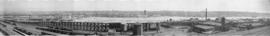
![[View of False Creek Flats east of Main Street]](/uploads/r/null/5/d/5d0a808a4da26519ee2390736b5c2eae8a157e0573957fb8f67b825a709d20b0/7a5da500-ffa2-4229-8459-c2aed940a8d5-A62328_142.jpg)
[View of False Creek Flats east of Main Street]
Part of Major Matthews collection
Panoramic view showing the Great Northern Railway Station, construction site for the Canadian National Railway Station, the Main Street bascule bridge and the Invanhoe Hotel.
![[View of False Creek Flats east of Main Street]](/uploads/r/null/2/2/22ae18e3c70f3b175e8da170286e28bec8b9c5badf5f7209cd805214ba4c2778/0054a24e-3793-409f-a191-486d3c0e0479-A63167_142.jpg)
[View of False Creek Flats east of Main Street]
Part of Major Matthews collection
Panoramic view showing the start of the False Creek reclamation, the Great Northern Railway Station construction site, the Main Street bascule bridge, Market Hall and Ivanhoe Hotel.
![[View of False Creek from the Burrard Bridge]](/uploads/r/null/a/1/a1fc4701217f9c0ae31c19c9633ecbb4bd755c8cb0943f95eff5cd79ae956917/68e480f6-01eb-4f84-818e-5d3fff88bc4e-A76140_142.jpg)
[View of False Creek from the Burrard Bridge]
Part of James Crookall fonds
Photograph shows the Kitsilano Trestle Bridge and Granville Bridge
![[View of False Creek from the Burrard Bridge]](/uploads/r/null/f/b/fbd61aeef21963d52cdf1d9bebfb76c3f8130414b4beedc138f557b46485122c/c49ef575-2edf-4f80-89cb-0e5daf40eb93-A76141_142.jpg)
[View of False Creek from the Burrard Bridge]
Part of James Crookall fonds
Photograph shows the Kitsilano Trestle Bridge, part of Granville Island (including the B.C. Equipment Co. buildings) and the Granville Bridge