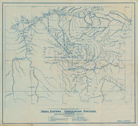
Sketch plan of north eastern Venezuelan Guyana
- AM45---: LEG1097.05
- Item
- [1924?]
Part of John Leckie fonds
Item is a map showing rivers, diamond and gold deposits, former Spanish mission stations, farms, ranches, waterfalls, bush lines, railway projects, and state and national boundaries. Concentric circles show distances from Tumeremo. Additonal locations have been annotated in pencil.
