
Hot sulphur springs Banff National Park
- AM54-S4-: SGN 275
- Item
- [189-?]
Part of Major Matthews collection
328 results directly related Exclude narrower terms
Hot sulphur springs Banff National Park
Part of Major Matthews collection

Bow River Valley and C.P.R. hotel, Banff National Park
Part of Major Matthews collection
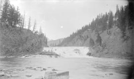
Bow River Falls, Banff National Park
Part of Major Matthews collection
Photograph shows a horse and carriage on a bridge in front of the falls and mountains in the distance.
Bow River Falls, Banff National Park
Part of Major Matthews collection

Banff National Park from Cave Hot Springs
Part of Major Matthews collection
Photograph shows hot springs and surrounding buildings in the foreground, and mountains in the distance.
Part of L.D. Taylor family fonds
Front cover of album is embossed "L.D. Taylor, Canadian Northern Railway System".
Part of Major Matthews collection

Devil's Creek Canyon, Canadian National Park
Part of Major Matthews collection
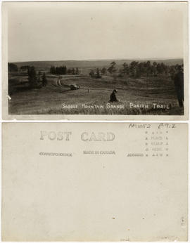
Saddle Mountain Grande Prairie Trail
![Welcome at Tollerton [townsite]](/uploads/r/null/d/0/d05ca6d4c6e631f23896d7574b29985298e3abbcc9997d0931eab9a21a71beed/88525ad6-508f-4e5a-bcba-42d256030eb7-A51126_142.jpg)
Welcome at Tollerton [townsite]
Part of L.D. Taylor family fonds
Photograph shows a crowd of people, mostly men with instruments, outside of a building
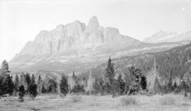
The Colin Range: Old Man Mountain on the right
Part of L.D. Taylor family fonds
Part of L.D. Taylor family fonds
![Oil country - [Men at oil well in Turner Valley, Alberta]](/uploads/r/null/5/c/5cc9b2914d8cccf04c1adf454945d8d309a32f66c22752fddc51c987daf8eb5f/a2e77bf8-d3e5-4d10-a54a-5cc7f42f1ca8-CVA1477-665_142.jpg)
Oil country - [Men at oil well in Turner Valley, Alberta]
Part of L.D. Taylor family fonds
Photograph taken during visit by L.D. Taylor.
![Army convoy [to Banff National Park]](/uploads/r/null/a/e/aeeb7fed1f8c15eea9142832b6ed5b90b00d9e516ecad4d2ce78208ba97ba2c8/5aca2f02-9da4-4e05-9240-162c5ffe2ed7-A05729_142.jpg)
Army convoy [to Banff National Park]
![[Harvesting scene]](/uploads/r/null/e/6/e60aa02211942333429fe7d9a7e16ca76767a96123aaf4b8ce8ba22041174bd4/9a6eda12-9448-4786-9d57-043ac09eb996-A07007_142.jpg)
Photograph shows a tractor, thrashing machine and workers. Inscription on verso of print "#1426 - Alberta Harvest scene near Calgary, Alberta. / Don Coltman Photo"

Duke and Duchess of Windsor watching calf-branding at Bar U Ranch
![Duke and Duchess of Windsor watching [a cattle drive] at Bar U Ranch](/uploads/r/null/3/b/3b140bf006bb5acfccaef86da6199bd69ea45aa41a033249d1c078461efe6d6c/80be9c1f-8989-4b76-8d66-2b592ea911db-A07334_142.jpg)
Duke and Duchess of Windsor watching [a cattle drive] at Bar U Ranch

![View of Lake Louise [and the Rocky Mountains]](/uploads/r/null/e/a/ea6751400a037235d94d20c80f6e24a9e11a45acd3a519334766c12651f71272/99da980a-2b71-40b8-bf7f-7b72a6206a3c-A07037_142.jpg)
View of Lake Louise [and the Rocky Mountains]


![[View of] Lake Louise [and Rocky Mountains]](/uploads/r/null/7/b/7bfe3b977e314711cad2ccfc68eaaacb11dd78dfb73b09d3b26aab7d9732ecf5/bb6850cd-1e7c-4d95-a16e-d626ddd7b16e-A07034_142.jpg)
[View of] Lake Louise [and Rocky Mountains]
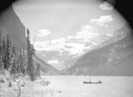
![[Canoe on] Lake Louise](/uploads/r/null/9/f/9fe7dfe1017f9a6397c74d5508a13b6392d71e9a3082eaeb3b70a95be3b870ee/5c523e42-60df-4bfc-b62d-d5c13ed4003a-A07033_142.jpg)
![[Harvesting scene showing men, equipment and vehicles]](/uploads/r/null/e/5/e5bdf63691b4326b1c476a0f8f52a4974a96e2790d095c38989e8018ed68b934/f6ee447b-c992-4c5c-830a-e7eda639a4cd-A07008_142.jpg)
[Harvesting scene showing men, equipment and vehicles]
![[Stoney Indian group listening to a radio on Calgary Stampede grounds]](/uploads/r/null/f/3/f3bd337993685974f0c75dabcedbee998015146e3df2ac0e90742ebfe239ac79/65d0fc2c-2ebf-4e31-83f3-8739fc0cf8cc-A07006_142.jpg)
[Stoney Indian group listening to a radio on Calgary Stampede grounds]

![[View of] Lake Louise](/uploads/r/null/b/b/bb49cfa5cf29855d86e785ac43f1ece22851cf123b724c607f214ac0538f8872/201b3ae7-1570-485e-809b-4acce498da11-A07003_142.jpg)
![Small school house [in the] Rockies](/uploads/r/null/b/6/b62769dd2490c9c43e3d5847451143dceb831b28ce6d456d86e7185aa3d1139c/06554686-f796-4f53-ae43-d733a506b2ae-A06997_142.jpg)
Small school house [in the] Rockies
![[View of Lake Louise]](/uploads/r/null/4/1/417954a9593f6caa68e2ba11c2fbb0c189f8ac5dbe00070d896819f0f3e18a0b/5e0cfce7-a241-404d-9d6f-e0633c09ccf5-A06982_142.jpg)
Photograph shows two women with canoes on shore.

photograph shows view of Mountainholm Lodge


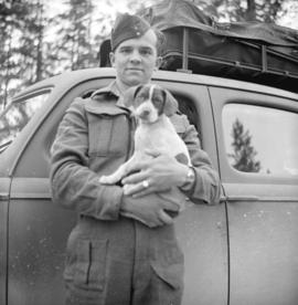
Photograph shows a soldier holding a puppy
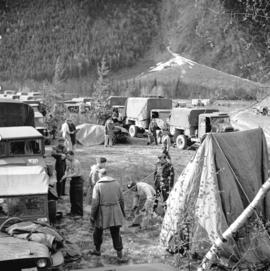
Photograph shows setting up a camp

Photograph shows soldiers with their mess kits eating outdoors

Photograph shows a truck crossing Big Mouth Creek

Photograph shows soldiers in front of an abandoned log cabin

Photograph shows a motorcyclist warming his hands over a fire
![Army convoy [to Banff National Park]](/uploads/r/null/3/1/31f121a5fe17c71607b382c003b3279534aa8dcddda59a6edbb03ff87c016cfc/b845aa08-9e63-4d7c-b19e-bf46e3394494-A05731_142.jpg)
Army convoy [to Banff National Park]
![Army convoy [to Banff National Park]](/uploads/r/null/6/a/6aaf69132da95e80f701f1d304423801ba040ec1274f248d7797150d8c58b1e3/4d3530cd-a1f2-49b6-8e61-4fd338a5c342-A05730_142.jpg)
Army convoy [to Banff National Park]
Photograph shows a photographer standing on the hood of a Jeep
![Army convoy [to Banff National Park]](/uploads/r/null/a/0/a0ac67c2bfc8687c7128202d9cf6928748f3f8df88fd918fee4beeffd6948e9f/381c8d91-63e5-41f0-af87-395ced16474f-A05728_142.jpg)
Army convoy [to Banff National Park]
![Army convoy [to Banff National Park]](/uploads/r/null/b/2/b24186714c57506da40a77d2fd21b454acfdc02b6af23e51d77f4b969abdf38e/5d80dc9e-c0c1-47a7-b2ef-01f476d10954-A05727_142.jpg)
Army convoy [to Banff National Park]
Photograph shows soldiers clearing a land slide from the road
![Army convoy [to Banff National Park]](/uploads/r/null/d/4/d4f33e7a7c48af3ac5e44ae50a2b29dfe02f0c6607a45e4652b5cd79bfb62978/5702a70c-62d7-424a-82f8-d12cc3c1cce7-A05726_142.jpg)
Army convoy [to Banff National Park]
Photograph shows Don Coltman standing on the hood of a Jeep
![Army convoy [to Banff National Park]](/uploads/r/null/5/e/5e9efce360604c6a5b8a54f3202938d11d25f48210da8e0ae53aa156d5a55603/39ac7af2-8f1f-4ef5-a372-2d839e0ddf42-A05724_142.jpg)
Army convoy [to Banff National Park]
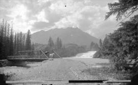
Photograph shows a bridge over the Kicking Horse River
![Army convoy [to Banff National Park]](/uploads/r/null/6/4/64fbd2f049f8d911ace69ca9dd48c33ea84a05e1b7bb26d1e4074ec2e93d1506/f7d7f150-2d3e-48d2-8fc0-417e7256fe9d-A05721_142.jpg)
Army convoy [to Banff National Park]
![Army convoy [to Banff National Park]](/uploads/r/null/0/9/096952bf0638774d3a685fdd1798d12e04c3ed964aa3068c9d8340e5b886d3c2/231b3c62-5466-4f60-a23a-41fec13875a7-A05720_142.jpg)
Army convoy [to Banff National Park]
![Omuxapop Okrista [Indigenous woman]](/uploads/r/null/4/3/43c8734e6b33a70b7240fdfb2698fb363ae0de35fb53e9c1643230d0b525d590/697b8940-1782-40c4-aa82-34990fffd363-A63367_142.jpg)
Omuxapop Okrista [Indigenous woman]
Item is a photograph showing a full-length portrait of an Indigenous woman smoking a pipe. The caption "Omuxapop Okrista, Old Sarcee Squaw" is written on the front of the photograph.

Part of City of Vancouver Archives technical and cartographic drawing collection
Item is a map showing the extent of the Canadian Pacific Railway Company (C.P.R.) in Canada in 1883. Map shows boundaries, roads, trails, telegraph lines, towns, rivers, lakes and mountainous terrain in British Columbia, the North West Territory (Alberta, Athabasca, Saskatchewan, Assiniboia), Manitoba and Kewaydin, as well as some of Ontario and Western Quebec. Map is folded inside a book titled "North West Territory, Canada."