Item : LEG1221.1 - Age of buildings

Age of buildings : Slocan Street to Boundary Road and Wall Street/East Street [Edinburgh Street] ... Age of buildings : Knight Street to Wales Street/Vivian Street and 37th Avenue to 53rd Avenue Age of buildings : Knight Street to Elliott Street and 53rd Avenue to Kent Avenue Age of buildings : Nanaimo Street to Jellicoe Street and S.E. Marine Drive to Kent Avenue Age of buildings : Jellicoe Street to Boundary Road and S.E. Marine Drive to Kent Avenue Age of buildings : Main Street to Clark Drive and Prior Street/Venables Street to Broadway Age of buildings : Main Street to Clark Drive/Knight Street and Broadway to King Edward Avenue Age of buildings : Main Street to Knight Street and King Edward Avenue to 41st Avenue Age of buildings : Quebec Street to Knight Street and 41st Avenue to 57th Avenue Age of buildings : Main Street to Knight Street and 57th Avenue to Kent Avenue 1954 : Age of buildings : Maps 20 and 21 : Downtown and West End Age of buildings : Slocan Street to Boundary Road and Pender Street to 5th Avenue 1954 : Age of buildings : Maps 20 and 21 : Downtown and West End Age of buildings : Oak Street to Main Street and Broadway to King Edward Avenue Age of buildings : Oak Street to Quebec Street and 41st Avenue to 57th Avenue Age of buildings : Fremlin Street to Main Street and 57th Avenue to Kent Avenue Age of buildings : Arbutus Street to Oak Street and Odgen Avenue to Broadway Age of buildings : Arbutus Street to Oak Street and Broadway to King Edward Avenue Age of buildings : Arbutus Street to Oak Street and King Edward Avenue to 41st Avenue Age of buildings : Maple Street to Oak Street and 41st Avenue to 57th Avenue Age of buildings : Arbutus Street/S.W. Marine Drive to Fremlin Street and 57th Avenue to 72nd Avenue Age of buildings : Granville Street to Fremlin Street and 72nd Avenue to 75th Avenue Age of buildings : Slocan Street to Boundary Road and 5th Avenue to 22nd Avenue Age of buildings : Blenheim Street to Arbutus Street and Point Grey Road to Broadway Age of buildings : Blenheim Street to Arbutus Street and Broadway to King Edward Avenue Age of buildings : Blenheim Street to Maple Street and King Edward Avenue to 41st Avenue Age of buildings : Blenheim Street to Maple Street/Laburnum Street and 41st Avenue to 57th Avenue Age of buildings : Blenheim Street to Arbutus Street and 57th Avenue to the North Arm of the Fras... Age of buildings : Discovery Street to Blenheim Street and Point Grey Road to 10th Avenue Age of buildings : Discovery Street to Blenheim Street and 10th Avenue to King Edward Avenue Age of buildings : Camosun Street to Blenheim Street and King Edward Avenue to 41st Avenue Age of buildings : Crown Street to Blenheim Street and 41st Avenue to 55th Avenue Age of buildings : University Endowment Lands to Discovery Street and Hadden Avenue to 10th Avenue Age of buildings : Slocan Street to Boundary Road and 22nd Avenue to Kingsway Age of buildings : Blanca Street to Discovery Street and 10th Avenue to 16th Avenue Age of buildings : Clark Drive to Slocan Street and Hastings Street to 6th Avenue Age of buildings : Main Street to Clark Drive and Railway Street/Powell Street to Prior Street/Ve... Age of buildings : Oak Street to Main Street and 6th Avenue/2nd Avenue to Broadway Age of buildings : Oak Street to Main Street and King Edward Avenue to 41st Avenue Age of buildings : Wales Street/Vivian Street to Boundary Road and Kingsway to 52nd Avenue Age of buildings : Vivian Street to Boundary Road and 52nd Avenue to S.E. Marine Drive Age of buildings : Clark Drive to Slocan Street and Powell Street/Wall Street to Hastings Street Age of buildings : Clark Drive/Knight Street to Slocan Street and 6th Avenue to 22nd Avenue Age of buildings : Knight Street to Slocan Street/Wales Street and 22nd Avenue to 37th Avenue

Title and statement of responsibility area

Title proper

Age of buildings

General material designation

  • Cartographic material

Parallel title

Other title information

Title statements of responsibility

Title notes

Level of description

Item

Reference code

COV-S445-3-: LEG1221.1

Edition area

Edition statement

Edition statement of responsibility

Class of material specific details area

Statement of scale (cartographic)

Scale not defined

Statement of projection (cartographic)

Statement of coordinates (cartographic)

Statement of scale (architectural)

Issuing jurisdiction and denomination (philatelic)

Dates of creation area

Date(s)

  • 1954 (Creation)

Physical description area

Physical description

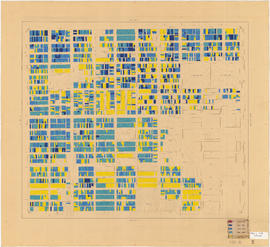
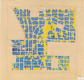
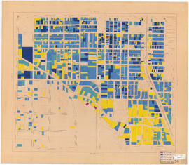
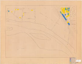
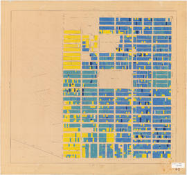
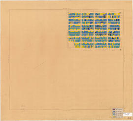
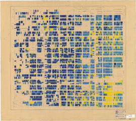
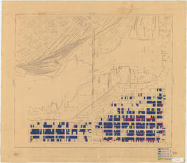
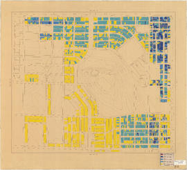
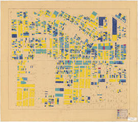
1 map (44 sheets) : diazotype, hand col., annot., mounted on linen ; 92 x 114 cm or smaller

Publisher's series area

Title proper of publisher's series

Parallel titles of publisher's series

Other title information of publisher's series

Statement of responsibility relating to publisher's series

Numbering within publisher's series

Note on publisher's series

Archival description area

Name of creator

Custodial history

Scope and content

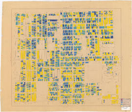
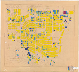
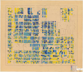
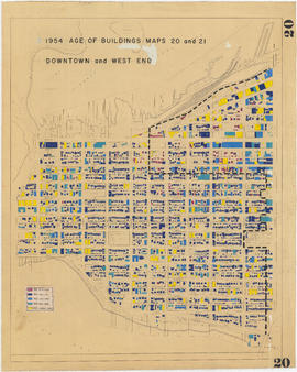
Item is a map in sectional form, annotated to show date of construction of buildings in Vancouver by the following categories: Up to 1899; 1900-1915; 1916-1930; 1931-1945; since 1946. Base map shows streets, topographic contour lines, and some building outlines.

Notes area

Physical condition

Immediate source of acquisition

Arrangement

Language of material

Script of material

Location of originals

Availability of other formats

Restrictions on access

Terms governing use, reproduction, and publication

Finding aids

Associated materials

Related materials

Accruals

Alpha-numeric designations

Plan no. 4562A

Rights

Copyright: City of Vancouver; expiry: 2030

Alternative identifier(s)

Standard number area

Standard number

Access points

Subject access points

Place access points

Name access points

Genre access points

Rights area

Accession area

Related subjects

Related people and organizations

Related places

Related genres