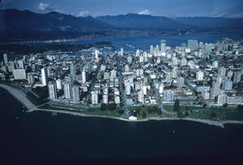
Aerial view of the West End peninsula
- AM1661-: CVA 238-10
- Item
- Sept. 1968
Part of Frank Appelbe fonds
463 results directly related Exclude narrower terms
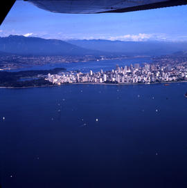
Aerial view of the West End peninsula
Part of Frank Appelbe fonds

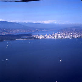
Aerial view of the West End peninsula
Part of Frank Appelbe fonds
![[Aerial view of the West End showing the increase of apartment buildings west of Cardero Street]](/uploads/r/null/9/4/9410444a29ad3e6e13228ba5ad44b40986af7ad70945337641000d03b991a529/ee9fb9e8-21b9-4ca5-a5b6-d28e6d51046e-A25977_142.jpg)
[Aerial view of the West End showing the increase of apartment buildings west of Cardero Street]
Part of Major Matthews collection
Photograph shows oblique view of Lost Lagoon, Stanley Park and Lord Roberts School

Aerial view of three bridges at Second Narrows
Part of Vancouver Express fonds
Item is a photograph showing an aerial view of three bridges at Second Narrows. Caption from Vancouver Express: "Three bridges at Second Narrows will soon be down to two as old structure (centre) is slated for demolition. Rail traffic which once used old bridge now travels over CN rail bridge which was completed last year. Aerial photo was taken from Harrison Airways Cessna 172, piloted by Hugh Fraser."
![[Aerial view of Vancouver]](/uploads/r/null/1/8/18f00497f9008905bcbff6f62bdc7c5625e266a0ac6b757f9d501d5684921d8a/b6974d97-c2a6-46b1-b55e-581ed03796c9-A23519_142.jpg)
Part of Major Matthews collection
Oblique view. Photograph shows the Westend, Downtown, Coal Harbour and Burrard Inlet.
![[Aerial view of Vancouver]](/uploads/r/null/d/7/d7f280a1021ddedf2aae71722e35fd9ee91a1e6d3f2e31003eed6fec146e27e7/e30c0e8a-964a-484e-90db-349ad9165b2f-A13725_142.jpg)
![[Aerial view of Vancouver]](/uploads/r/null/9/b/9b3acec26123edc53f11bf2f41f3286d09254ffea9918cd31b6715395ebe18d0/26473909-fe49-4474-8c3f-05eb1e8ab059-CVA1376-252_142.jpg)
Oblique view showing Fairview, Vancouver General Hospital, False Creek and the Expo 86 and other sites under development on the north side, Granville Island, Granville Bridge, Burrard Bridge, Yaletown, Downtown, the West End, Stanley Park and the Lions Gate Bridge, North Vancouver and The Lions in the background
![[Aerial view of Vancouver]](/uploads/r/null/a/e/aea3d75fc7ebb88b78ad9efab62904bc9667abedf965cfd73ee6efd909a5e01b/ec4fb3c6-e62c-4383-b7f4-a31a2c2c00d1-A23515_142.jpg)
Part of Major Matthews collection
Photograph shows Lord Byng Secondary School buildings and grounds and Point Grey.
![[Aerial view of Vancouver]](/uploads/r/null/b/9/b973b9a4143a5316b02e728c35d99e383f27a3db21d8e20aa7bbb459780243bc/3ff38b56-6b36-4c17-bce1-329c97459d29-A66598_142.jpg)
Part of Major Matthews collection
Photograph shows Kitsilano, Kits Point, Kitsilano Beach, R.C.A.F. Equipment Depot, Kitsilano Pool, Burrard Bridge, C.P.R. Kitsilano Trestle, Granville Island, Granville Bridge, Cambie Bridge, False Creek, C.P.R. False Creek Yards, West End, Yaletown, Arbutus Ridge, Shaughnessy, South Cambie, Fairview, Mount Pleasant, Little Mountain Reservoir, Connaught Park, Quilchena Golf Course, Douglas Park, Shaughnessy Heights Golf Course, Queen Elizabeth Park, Royal Canadian Mounted Police Barracks, Shaughnessy Military Hospital, Hillcrest Park, Robertson & Hacket Sawmill, City Yard, West Coast Ship Builders and Athletic Park.
![[Aerial view of Vancouver]](/uploads/r/null/b/6/b61e5089ec8edb824f16eea9b4373dfb3ac9ea83b052f855a90859c3a7424f4c/c7a56b73-012c-4e6d-b4e3-c362735e3a05-A13726_142.jpg)

Oblique view showing the Burrard and Kitsilano Trestle Bridges, Kitsilano, Fairview, Granville Island and the West End and Downtown in the background

Oblique view showing False Creek including shipyards and east Vancouver
![[Aerial view of Vancouver]](/uploads/r/null/b/4/b48d4b96f8547ec1a2bf06286a2cb6ded5510700d395242e2bcb283c884cdcc0/3730cb73-0bef-4e47-843a-9953c8d8e913-A13729_142.jpg)
![[Aerial view of Vancouver]](/uploads/r/null/7/0/70fe55216d34bcc4ff4f671e2d7814e6d15c21dd5aaf76b58bc6469a40388a1d/c25263bf-0975-439c-bc93-248713d79567-A13722_142.jpg)

Oblique view showing the Burrard and Kitsilano Trestle Bridges, Kitsilano, Kitsilano Point, Fairview, Granville Island and the West End and Downtown in the background

Oblique view showing a waterfront

Oblique view showing Downtown inclusding St. Paul's Hospital, Sir William Dawson School, the second and third Hotel Vancouver, the Marine Building, Pier A-B and the eastern waterfront

Aerial view of Vancouver : looking north west showing shoreline and Kitsilano Beach
Part of Frank Appelbe fonds

Aerial view of Vancouver : looking north west showing shoreline and Kitsilano Beach
Part of Frank Appelbe fonds

Aerial view of Vancouver : looking north west showing shoreline and Kitsilano Beach
Part of Frank Appelbe fonds

Part of Frank Appelbe fonds

Part of Frank Appelbe fonds

Part of Frank Appelbe fonds

Part of Frank Appelbe fonds

Part of Frank Appelbe fonds

Part of Frank Appelbe fonds

Part of Frank Appelbe fonds

Part of Frank Appelbe fonds

Part of Frank Appelbe fonds

Part of Frank Appelbe fonds

Part of Frank Appelbe fonds

Part of Frank Appelbe fonds

Part of Frank Appelbe fonds
Part of Frank Appelbe fonds

Part of Frank Appelbe fonds

Part of Frank Appelbe fonds

Part of Frank Appelbe fonds

Part of Frank Appelbe fonds
Part of Frank Appelbe fonds

Part of Frank Appelbe fonds

Part of Frank Appelbe fonds

Part of Frank Appelbe fonds

Part of Frank Appelbe fonds

Part of Frank Appelbe fonds

Part of Frank Appelbe fonds

Part of Frank Appelbe fonds

Part of Frank Appelbe fonds

Part of Frank Appelbe fonds

Part of Frank Appelbe fonds

Part of Frank Appelbe fonds