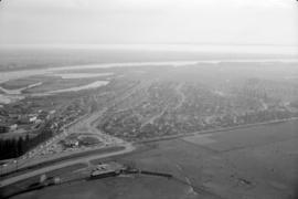
![[Aerial view from helicopter] - Shaughnessy and Quilchena](/uploads/r/null/f/f/0/ff08aaeeaea21ae38140e18966d54e6d4a93b1988c3516e585585ee218a6a227/a865e632-a40a-42f1-a10d-7c9f5a6c7cba-CVA160-22_142.jpg)
[Aerial view from helicopter] - Shaughnessy and Quilchena
- AM427-S4-: CVA 160-22
- Item
- Aug. 26, 1963
Part of William Orson Banfield fonds
1100 results directly related Exclude narrower terms
[Aerial view from helicopter] - Shaughnessy and Quilchena
Part of William Orson Banfield fonds
![[Aerial view from helicopter] - Shaughnessy Golf Club House](/uploads/r/null/5/d/5/5d5d8792969484ccece23357dbd8823275df30c087900509f9ad9548c867dd0d/09e33ad9-ff16-4e4b-9552-5a181fd0d2dc-CVA160-23_142.jpg)
[Aerial view from helicopter] - Shaughnessy Golf Club House
Part of William Orson Banfield fonds
![[Aerial view from helicopter] - Trans Canada Highway](/uploads/r/null/1/0/e/10eef24038760063ce10fb3c6ba332e347f7b483f567bc9c2ceac3b840575f22/e9e59724-c506-4e86-a00a-d9720b792c65-CVA160-21_142.jpg)
[Aerial view from helicopter] - Trans Canada Highway
Part of William Orson Banfield fonds
![[Aerial view from helicopter] - West Point Grey](/uploads/r/null/a/d/2/ad2d7a1729e13d635ae471fddd372c80d39e4234716f35b4990f68e863b2f236/3785ce48-0e53-4fa7-be64-30e658feab6f-CVA160-15_142.jpg)
[Aerial view from helicopter] - West Point Grey
Part of William Orson Banfield fonds
![[Aerial view looking east of downtown Vancouver and the waterfront]](/uploads/r/null/a/1/a146c28159c45997dd3312d8a94967907da12e5b5c1139902f95665ab0e54675/740905a3-6e61-4ffc-bc08-d90ad82bc7d8-A67011_142.jpg)
[Aerial view looking east of downtown Vancouver and the waterfront]
Part of Major Matthews collection
Oblique view shows the Immigration buildings, C.P.R. Piers A, B and C, the Courthouse, Hotel Vancouver, Marine building and Vancouver block.
![[Aerial view looking east over Point Grey]](/uploads/r/null/6/e/6e6142341e688a43c05c88b90455b7a0b9857daa4b8b976c384474e010017e9b/d7b03617-741e-42e1-a20f-006407c2e6be-A43249_142.jpg)
[Aerial view looking east over Point Grey]
Part of Major Matthews collection
Oblique view
![[Aerial view looking east over Stanley Park, Coal Harbour and Burrard Inlet]](/uploads/r/null/d/0/d02fee694c486ac2accdeefb505d0dae5fcb42789ef16de49322d845e3c04b44/be8c34ce-7c09-4c0e-a395-f083c9134080-A43248_142.jpg)
[Aerial view looking east over Stanley Park, Coal Harbour and Burrard Inlet]
Part of Major Matthews collection
Oblique view
![[Aerial view looking east over the West End and Vancouver Harbour]](/uploads/r/null/7/2/72a6a15fa5e8b8bb00446ded690554cbc6e31a707a1b358bde2c463fbd514287/86590540-e15a-410c-8083-495eb213a7ca-A63256_142.jpg)
[Aerial view looking east over the West End and Vancouver Harbour]
Part of Major Matthews collection
Oblique view showing Lost Lagoon, Brockton Point and Deadman's Island
![[Aerial view looking east towards the Second Narrows (Iron Workers Memorial) Bridge]](/uploads/r/null/a/3/a30e769b11d82234857ac24837baf510f2440359b92782f8e65bf107d5c50ffe/d0897c6d-49e8-4e61-b76c-6f04433a9e5b-A43252_142.jpg)
[Aerial view looking east towards the Second Narrows (Iron Workers Memorial) Bridge]
Part of Major Matthews collection
Oblique view showing the cantilever open
![[Aerial view looking north from False Creek]](/uploads/r/null/0/8/081746026b1559c2ace13027d77c668cba79e15800d0ca6ca466b205529e45b3/ce072490-3b01-4b65-8d61-bfaa102cca83-A43247_142.jpg)
[Aerial view looking north from False Creek]
Part of Major Matthews collection
Oblique view showing the West End and Downtown in the background
![[Aerial view looking north of the] Vancouver Wharves Ltd.](/uploads/r/null/a/3/a3e50a2d6a7688fca44a9f2fae2ec7ad724640047b3512a075ae83d4e5a3378e/ce172262-4f02-498d-ab6c-e23b06e50b09-A23502_142.jpg)
[Aerial view looking north of the] Vancouver Wharves Ltd.
Part of Major Matthews collection
Oblique view. Photograph shows P.G.E. yards, L & K Lumber, Norgate waterfront and West Vancouver.
![[Aerial view looking north over Downtown]](/uploads/r/null/4/b/4b54e616319b32d55e40e5c7404b5eccbd9b053f144a101245a1e709d1cfd4d2/1752a263-31cd-4155-880a-ead0fa54c115-A43250_142.jpg)
[Aerial view looking north over Downtown]
Part of Major Matthews collection
Oblique view showing part of the West End, the north end of the Granville Street and C.P.R. Kitsilano Trestle bridges, log booms, industries and the waterfront of False Creek and the C.P.R. docks and Burrard Inlet in the background
![[Aerial view looking north over] Granville Island](/uploads/r/null/8/3/83f9be0a597100103c181fa4d68c68baa4a0802471126afafea3b7850103e12b/ea9e7fb6-7465-4fa6-8fa9-18923e3d9307-A49646_142.jpg)
[Aerial view looking north over] Granville Island
Oblique view showing the Granville Bridge and the new Granville Bridge under construction, the Kitsilano Trestle Bridge, of the Burrard Bridge and the industrial and undeveloped areas on the north and south sides of False Creek
![[Aerial view looking north-east of the] District of North Vancouver](/uploads/r/null/9/5/95a056a0d3b5e734a0ac2527276ac4aca69e5dade031eb57596c7d359c95cdc4/50dcb21d-5cb6-41b7-ba47-eab3470af912-A23497_142.jpg)
[Aerial view looking north-east of the] District of North Vancouver
Part of Major Matthews collection
Oblique view. Photograph shows Deep Cove, Dollarton, Sherwood Park subdivision, Keith Road and Indian Arm.

Aerial view looking northeast over Hastings Park
Item is a photograph depicting an oblique view showing Renfrew Street, the Hastings Park race track, the amusement park including the roller coaster, exhibition buildings, Callister Park and the houses between Oxford Street, Triumph Street, Kaslo Street and Renfrew Street.
![[Aerial view looking northwest of the West End and Stanley Park]](/uploads/r/null/8/8/7/887dd5ff7e349fb28124477bf87837887e09eb02be29444c2ab484fb9068ab51/a90b562e-ef47-480e-b13c-5cb26250e139-CVA374-181_142.jpg)
[Aerial view looking northwest of the West End and Stanley Park]
Oblique view showing English Bay, Lost Lagoon, Coal harbour and West Vancouver in the background
![[Aerial view looking northwest over Downtown]](/uploads/r/null/b/7/b7ca69254d2cbe14ffd3cb21ed6f3b1fed68dde7a4a5843876f8c173674d9d01/a1129a0c-5269-4488-9376-66246af93f6d-A43286_142.jpg)
[Aerial view looking northwest over Downtown]
Part of Major Matthews collection
Oblique view showing the Cambie Street Bridge, the Georgia Viaduct, Pier B-C, Stanley Park, Coal Harbour, the Lion's Gate Bridge and West Vancouver in the background
![[Aerial view looking northwest towards the Downtown waterfront]](/uploads/r/null/c/c/cc62f979c7614b3405e2bfbfcd8cf6172232e958fc2dcd17a970dbbf3d28b4d8/4699d55d-d238-4161-854b-fa983bd7d738-A71613_142.jpg)
[Aerial view looking northwest towards the Downtown waterfront]
Oblique view showing Harbour Centre (formerly Spencer's Department Store) and Lookout, the C.P.R. (Waterfront) Station, C.P.R. Pier B-C, the Marine and other buildings
![[Aerial view looking over the Downtown waterfront]](/uploads/r/null/1/6/1644eebceda09466c9aac6a8534ea82b04164ab39d5d756ec4cc902d5ba16e30/d4c9f855-498d-4971-a368-0f672d3a89a4-A71614_142.jpg)
[Aerial view looking over the Downtown waterfront]
Oblique view showing Burrard Street and the Marine and other buildings
![[Aerial view looking south of the] District of North Vancouver [between Seymour and Lynn Creeks]](/uploads/r/null/e/f/efec87eb86f83a0865fb63dd855e51942b3f5e6b75c5f105b15ef3db57d5b5c9/107091fb-3414-4f25-bc79-e59cee44fbab-A23496_142.jpg)
[Aerial view looking south of the] District of North Vancouver [between Seymour and Lynn Creeks]
Part of Major Matthews collection
Oblique view. Photograph shows Second Narrows, old and new Second Narrows Highway bridge, Indian Reserve No. 2 and Maplewood.

Aerial view looking south towards Vancouver Terminal Company grain elevators and docks
![[Aerial view looking south-east from Georgia and Richards Streets]](/uploads/r/null/6/c/6c978477f3016794445b1dbe13e34d3d2af52193ddab85b2cc38d0c769dc1e95/5ea94235-2dfb-47a7-b6e6-5e0e0ab48362-A23511_142.jpg)
[Aerial view looking south-east from Georgia and Richards Streets]
Part of Major Matthews collection
Oblique view. Photograph shows Beatty Street Armoury, houses and buildings in Yaletown and False Creek.
![[Aerial view looking south-west of the] District of North Vancouver](/uploads/r/null/0/d/0d8adb3b55d68b7df4c4925829b8ff3b87c6f13f3a1ec81d303a4854c57064b0/0e67b80d-8372-4feb-93c5-e9c63b1d4541-A23499_142.jpg)
[Aerial view looking south-west of the] District of North Vancouver
Part of Major Matthews collection
Oblique view. Photograph shows Norgate waterfront, P.G.E. yards and sheds, L & K Lumber, Vancouver Wharves Ltd. and Stanley Park.
![[Aerial view looking south-west of the] District of North Vancouver](/uploads/r/null/a/b/ab2ec4570d14f519cdac8220126fd3bf21b20665ef1313681e9bbfbb2e1dd1c5/69236007-852b-4154-94da-29459b1bc14a-A23495_142.jpg)
[Aerial view looking south-west of the] District of North Vancouver
Part of Major Matthews collection
Oblique view. Photograph shows Fern Street overpass, Bridgeman Park, Lynn Creek and Moodyville.
![[Aerial view looking west of the] District of North Vancouver](/uploads/r/null/9/5/958342bfc158583761e59a85838c811fc69beaa535cf44a6a97fc6da0b2b9fec/fc695e17-8926-494e-b8d0-bef82af0912c-A23498_142.jpg)
[Aerial view looking west of the] District of North Vancouver
Part of Major Matthews collection
Oblique view. Photograph shows Marine Drive from MacKay Creek to Capilano Indian Reserve No.5, Kiwanis Senior Citzens housing, Avalon Hotel, Dominion store and the Norgate Park subdivision.
![[Aerial view looking west over Burnaby towards Vancouver]](/uploads/r/null/3/e/3ee0bad707202c9fbcaad91d585345ec93cbe9ec0be93643a8c82dd4f323bdde/1d10f88f-abea-4b79-b07a-e27dfe5d6cd0-A71608_142.jpg)
[Aerial view looking west over Burnaby towards Vancouver]
Oblique view showing the former Kelly Douglas site (now Metrotown Mall), Kingsway and Central Park
![[Aerial view looking west over Burnaby towards Vancouver]](/uploads/r/null/a/1/a1972aaa0fedf64a8da64c0a3f99647764ec26034813d610dc060d54afdfe1bf/0b1d7503-6b52-44de-a829-67274f54d77c-A71609_142.jpg)
[Aerial view looking west over Burnaby towards Vancouver]
Oblique view showing the former Kelly Douglas site (now Metrotown Mall), Kingsway and Central Park
![[Aerial view looking west over Granville Island]](/uploads/r/null/d/5/d5e5021eedf545a1ee16153e245643d67a63469ee5d43b1eeee58dd438678103/8fac530f-b053-43dc-9ffa-94995fd358d1-A49645_142.jpg)
[Aerial view looking west over Granville Island]
Part of City of Vancouver fonds
Oblique view showing the Granville Bridge, the Kitsilano Trestle Bridge, the Burrard Bridge and log booms in False Creek
![[Aerial view looking west over Point Grey]](/uploads/r/null/d/a/da370c91b8519769814da89cd1136fcd3872aa71fca7a7f1b176e6534e9caaef/a1ff0d0e-189b-42d3-9ad4-090a410a7ea2-A43251_142.jpg)
[Aerial view looking west over Point Grey]
Part of Major Matthews collection
Oblique view showing the Jericho Beach Golf Course and the R.C.A.F. aerodrome
![[Aerial view looking west south-west of the] District of North Vancouver](/uploads/r/null/e/c/ec241a495ce73acb4df544a3511e33bf47855c3f9780f6fdf330d5e1998b35f4/4b33b03c-3b2c-434d-877d-de90ed039d2a-A23500_142.jpg)
[Aerial view looking west south-west of the] District of North Vancouver
Part of Major Matthews collection
Oblique view. Photograph shows Deep Cove, Panorama Park, Deep Cove Yacht Club, Public Wharf (foot of Gallant Avenue), Deep Cove Resorts and Deep Cove Park.
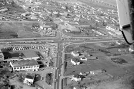
![[Aerial view of a shopping centre]](/uploads/r/null/1/5/156ef6b6f2bbd9391835c1b458d9e5fa7ba0e39f8fd2abeb2812e6ee46100008/a8e98ea8-442f-4d1a-acbf-ff2cc8319fa1-A71606_142.jpg)
![[Aerial view of a Trans-Canada flight over the Legislature Buildings]](/uploads/r/null/2/c/2c11ee8d03efbcf7ecadfbef3e61bc88240bece54cf13185b1a31de5f44ee0e8/554c34a1-7b7a-4613-bfd4-d5e38c3aa6a1-A33475_142.jpg)
[Aerial view of a Trans-Canada flight over the Legislature Buildings]
Part of Major Matthews collection
Oblique view
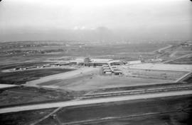
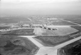
Aerial view of airport terminal, runways and approaches to Sea Island
Aerial view of airport terminal, runways and approaches to Sea Island

Aerial view of airport terminal, runways and approaches to Sea Island

Aerial view of airport terminal, runways and approaches to Sea Island
Aerial view of airport terminal, runways and approaches to Sea Island

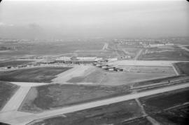
Aerial view of airport terminal, runways and approaches to Sea Island

Aerial view of airport terminal, runways and approaches to Sea Island
Aerial view of airport terminal, runways and approaches to Sea Island

Aerial view of airport terminal, runways and approaches to Sea Island
Aerial view of airport terminal, runways and approaches to Sea Island
![[Aerial view of Annacis Island and surrounding area during the Fraser River flood]](/uploads/r/null/8/6/86f336a392b2e63fe9ad7c407a94759fbba0440b22f898ac6f19d416451d16f4/07c70344-bc9e-42e2-81dc-f72a79dff600-A23475_142.jpg)
[Aerial view of Annacis Island and surrounding area during the Fraser River flood]
Part of Major Matthews collection

Aerial view of area surrounding Pacific Coliseum construction looking east

Aerial view of area surrounding Pacific Coliseum construction looking east

Aerial view of area surrounding Pacific Coliseum construction looking east

Aerial view of area surrounding Pacific Coliseum construction looking east

Aerial view of area surrounding Pacific Coliseum construction looking east

Aerial view of area surrounding Pacific Coliseum construction looking north

Aerial view of area surrounding Pacific Coliseum construction looking north