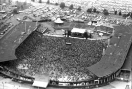
Aerial view of crowd at outdoor concert in Empire Stadium
- AM281-S8-: CVA 180-4264-: CVA 180-4264.11
- Part
- Aug. 27, 1978
1100 results directly related Exclude narrower terms
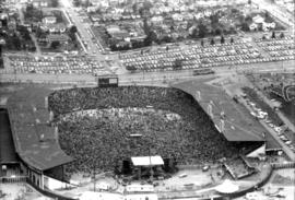
Aerial view of crowd at outdoor concert in Empire Stadium

Aerial view of crowd at outdoor concert in Empire Stadium

Aerial view of crowd at outdoor concert in Empire Stadium

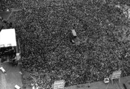
Aerial view of crowd at outdoor concert in Empire Stadium

Aerial view of crowd at outdoor concert in Empire Stadium

Aerial view of crowd at outdoor concert in Empire Stadium

Aerial view of crowd at outdoor concert in Empire Stadium

Aerial view of crowd at outdoor concert in Empire Stadium

Aerial view of crowd at outdoor concert in Empire Stadium

Aerial view of crowd at outdoor concert in Empire Stadium
Aerial view of crowd at outdoor concert in Empire Stadium
Aerial view of crowd at outdoor concert in Empire Stadium

Aerial view of crowd at outdoor concert in Empire Stadium

Aerial view of crowd at outdoor concert in Empire Stadium

Aerial view of crowd at outdoor concert in Empire Stadium
![[Aerial view of Douglas seaplane over Prince Albert, Saskatchewan on first trans-Canada flight]](/uploads/r/null/4/c/4ceb468f20cc28bbc9ae970a494663bbfa6ffd198b122e6d3a61b69f05a96aac/c3d0b10b-8479-4c33-98ce-1673ceb34cbd-A23389_142.jpg)
[Aerial view of Douglas seaplane over Prince Albert, Saskatchewan on first trans-Canada flight]
Part of Major Matthews collection
![[Aerial view of Downtown]](/uploads/r/null/1/d/1d3f6cb0fb1d1c4b0fbaff95c64f947cdc26d5ffaa6c212ae24596a4dd058682/394e8d98-3a08-405b-885e-173deb9ff8bd-A61433_142.jpg)
Part of Major Matthews collection
Oblique view showing Coal Harbour, Deadmans Island, Brockton Point and North Vancouver in the background
![[Aerial view of] downtown bounded by Burrard Street, West Georgia Street, Granville Street and Sm...](/uploads/r/null/9/1/a/91aa0079c35a13cc3a22b0f7df0fb214970095aab0b5d871e09523e0499e3dac/42b18aee-e75f-4548-9e3a-bf196c0130ce-CVA145-17_142.jpg)
Part of City of Vancouver fonds
![[Aerial view of Downtown looking west from Granville Street]](/uploads/r/null/1/0/10903c6f6eb76e95eb8087a1b33bce6b998145848d5cee0ac237f1c676b77644/7cecb0f6-a946-4166-8861-9f447cb59be7-A23492_142.jpg)
[Aerial view of Downtown looking west from Granville Street]
Part of Major Matthews collection
Oblique view. Photograph shows Court house building and grounds, Hotel Vancouver, Georgia Medical Dental Building, Vancouver Public Library and Coal Harbour.
![[Aerial view of downtown Vancouver]](/uploads/r/null/9/5/953f0d3ea8e3ecbb55e2210d94ead53f5be11ac38f8801476c6f0a576bc5953d/f265a01b-d073-47c0-99e1-e2832c475ddb-A13733_142.jpg)
[Aerial view of downtown Vancouver]
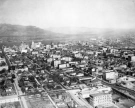
Aerial view of downtown Vancouver
Item is a photograph showing downtown and Vancouver Harbour with a partial view of Stanley Park.

Part of City of Vancouver fonds


Part of City of Vancouver fonds
Aerial view of downtown Vancouver looking north along Granville Street
![[Aerial view of Downtown Vancouver looking south from Burrard Inlet]](/uploads/r/null/3/2/32bc12be65a895f144d669768ee019e6abc83bc4018b11b3ecf96930fbd98786/024e645a-ce5d-4e73-a4e1-efb2ad9b7995-A71518_142.jpg)
[Aerial view of Downtown Vancouver looking south from Burrard Inlet]
Photograph shows Canada Place under construction, the SeaBus terminal, Waterfront Station (formerly the C.P.R. Station), the Marine Building, Harbour Centre and False Creek and Granville Island in the background


Part of City of Vancouver fonds

Aerial view of east half P.N.E. grounds looking south

Aerial view of eastern portion of Vancouver Harbour showing Vancouver Terminal

![[Aerial view of] English Bay Beach [the West End and Coal Harbour]](/uploads/r/null/b/b/bb7c88b9152ef2f0cd0c703a1f4b8ec3bb0049756fc1b2866fca72704a96421a/73ce5f2f-8ac1-4465-aa81-d5454e7356bb-A23489_142.jpg)
[Aerial view of] English Bay Beach [the West End and Coal Harbour]
Part of Major Matthews collection
Oblique view. Photograph shows apartment buildings west of Denman Street.
![[Aerial view of Evergreen Park Resort]](/uploads/r/null/9/d/b/9dbe08a7883091f0c43b98eebc02ef89b97cfdf03ccc32b018ce207bfc741457/c0e7fd04-3256-42c8-9328-0869e3731928-CVA374-319_142.jpg)
![[Aerial view of Evergreen Park Resort]](/uploads/r/null/2/4/4/244557fcfccb2526a22199fee0e714fd6116fc056c2fac4473e1e31cc0dfa124/57fc44e3-e476-42d8-b7f6-7b2cd5bbe3fb-CVA374-318_142.jpg)

Part of City of Vancouver fonds
Part of City of Vancouver fonds
Item is a photograph showing an aerial view from Oak Street to Pine Street, West 6th Avenue, and the north side of False Creek. Includes Granville Street Bridge, Granville Island and the Burrard Street Bridge.

Part of City of Vancouver fonds
Item is a photograph showing an aerial view from Spruce Street to Burrard Street, West 6th Avenue, and the north side of False Creek. Includes Granville Street Bridge, Granville Island and the Burrard Street Bridge.

Part of City of Vancouver fonds
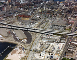
Item is a photograph showing the east end of False Creek. From just west of Columbia Street to just east of Main Street, West 2nd Avenue to Keefer Street. Includes the Georgia Viaduct and Dunsmuir Viaduct.


Part of City of Vancouver fonds

Part of City of Vancouver fonds

Part of City of Vancouver fonds

Part of City of Vancouver fonds

Part of City of Vancouver fonds
Part of City of Vancouver fonds

Part of City of Vancouver fonds