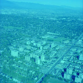
Aerial photograph of Kerrisdale
- AM980-S1-: CVA 804-392
- Item
- Dec. 12, 1979
Photograph shows Point Grey Secondary School, Kerrisdale Arena and 41st Avenue
1100 results directly related Exclude narrower terms
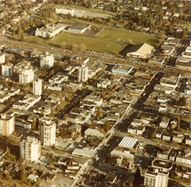
Aerial photograph of Kerrisdale
Photograph shows Point Grey Secondary School, Kerrisdale Arena and 41st Avenue
Aerial photograph of Kerrisdale
Photograph shows Point Grey Secondary School, Kerrisdale Arena and 41st Avenue

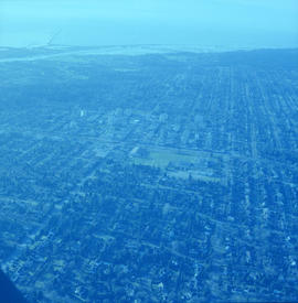
Aerial photograph of Kerrisdale

Aerial photograph of Kerrisdale
Photograph shows 41st Avenue

Aerial photograph of Kerrisdale
Aerial photograph of Kerrisdale

Aerial photograph of Kerrisdale
![[Aerial photograph of north Burnaby near intersection of Lougheed and Sperling]](/uploads/r/null/0/4/0402a7c6f7e8a28c8ca96ea5b930f8be591de0a42bfa4e4d588b57d8242e3df2/89b183bb-b4c9-4610-bd3d-233b78ca3218-A38735_142.jpg)
[Aerial photograph of north Burnaby near intersection of Lougheed and Sperling]
![[Aerial photograph of north Burnaby near intersection of Lougheed and Sperling]](/uploads/r/null/f/6/f6d5ee2897afb7fca08a02c5516b73fa64f9dffc0b96e41335272f5049bff318/5e860ead-2105-466e-9535-74449508fa1c-A38734_142.jpg)
[Aerial photograph of north Burnaby near intersection of Lougheed and Sperling]
![[Aerial photograph of north Burnaby near intersection of Lougheed and Sperling]](/uploads/r/null/a/c/acb6598698ac88b27910cc65b590d05b02972403e78fecc5ae1a368cd0c4886b/32a0806e-9249-4407-8edf-f969bf2582fb-A38736_142.jpg)
[Aerial photograph of north Burnaby near intersection of Lougheed and Sperling]

Aerial photograph of P.N.E. grounds

Aerial photograph of P.N.E. grounds and New Brighton area


Aerial photograph of P.N.E. grounds, including Agrodome, Livestock building, Pacific Showmart


Aerial photograph of P.N.E. Playland
![[Aerial photograph of the Alberta Wheat Pool elevators and shipping gallery]](/uploads/r/null/3/2/32dabc19b9a47ef8b896d54d0659490566097669fc4b47d2f53556b539abddda/989f5b86-0587-4af2-9362-01b4eea2b5d7-A25116_142.jpg)
[Aerial photograph of the Alberta Wheat Pool elevators and shipping gallery]
Part of Major Matthews collection
Oblique view shows the New Brighton Pool
![[Aerial photograph of the third CPR station]](/uploads/r/null/9/3/9363f69f5bfb9481d61b35900379670ba15b8e772331e9caa6991d35c9d56ba4/d6afd168-9017-4907-98a1-0d62f437998c-A49478_142.jpg)
[Aerial photograph of the third CPR station]
Part of H.A. Price collection
Aerial photograph shows the third CPR station. View is looking north. Image includes Granville Street, the Post Office, and the Customs Examining warehouse.
![[Aerial photograph of University of British Columbia Endowment Land area, showing some farm land]](/uploads/r/null/7/0/70e1f604470000e7a05baa46d299f27cb13e52173626249485a3a2586cb9f054/90b2a170-3763-41e7-a2ac-edba3984d880-A72733_142.jpg)
[Aerial photograph of University of British Columbia Endowment Land area, showing some farm land]
Part of Dunbar History Project fonds
Item filed under People and customs. Image shows Department of Agriculture farm.
Aerial photographs of P.N.E. grounds and crowd at outdoor concert in Empire Stadium
Item is a photograph showing the Summer Sunday '78 concert with performances by Heart, Little River Band, Bob Welch and Nick Gilder.
![Aerial pix of various landfill [1 of 2]](/uploads/r/null/4/b/4b64f19cdf8c8c258da84bd571f35c13db694387c6a0eda63ffe8975f1c34a7a/aaf98564-d3f5-4bd4-a4d5-3269ac147dcc-A66347_142.jpg)
Aerial pix of various landfill [1 of 2]
Part of City of Vancouver fonds
![Aerial pix of various landfill [2 of 2]](/uploads/r/null/e/7/e7703b220e446009ac90537bc812e9b18d5961bc3bef9af08496b7511b215a5c/b6eff842-b01a-4f53-9052-d169441bc572-A66348_142.jpg)
Aerial pix of various landfill [2 of 2]
Part of City of Vancouver fonds
Aerial shot from over Stanley Park
Item is a photograph showing Coal Harbour (left) and English Bay (right) and downtown buildings centre.
![Aerial shot [of Vancouver]](/uploads/r/null/c/c/0/cc035757f6056e5e389720ff3d3b0e7e6552cbc6be1f1c972742f757bcd3a956/83992969-d0c5-48e2-9424-c0c010dca053-2011-010_142.jpg)
![Aerial shot [of Vancouver]](/uploads/r/null/0/a/a/0aa98f09e32d52bf4e7b8c01bb2f0235468070788b009291a6b7a250fafeb0ab/02216a4e-d4d0-475e-b757-6d2d150fe4f3-2011-010_142.jpg)
![Aerial shot [of Vancouver]](/uploads/r/null/6/2/0/62049c44c41e27f9fe84da5fb0c74b557386495259f6d5672986c10db795f7ba/64749fb0-a849-4863-ac34-8086bb1fbb5f-2011-010_142.jpg)
![Aerial shot [of Vancouver]](/uploads/r/null/c/1/0/c10af4f74e877231e7f762f21a3e7573025487ea7628e2203fa8059be348614d/c727b0e2-4b73-42fc-8beb-38999fa31ba2-2011-010_142.jpg)
![Aerial shot [of Vancouver]](/uploads/r/null/f/c/c/fcc129728ab4d72f4aa71fbff5f147adfc18ef2cf52c9c185c735a3bba89e1ca/09c4738e-b929-489f-b40f-df3d3f14a14a-2011-010_142.jpg)
![Aerial shot [of Vancouver]](/uploads/r/null/7/1/0/7103b7b5134535566200ccd1ab6019b45532c70ac1d912038736af953873f1a0/c079986f-cb08-40d2-86c5-7d1d311ebd89-2011-010_142.jpg)
![Aerial shot [of Vancouver]](/uploads/r/null/d/f/9/df9c128ea494424f20f4032e34a27f6c3053e1c3d9b2864ada5a93bfcef3e447/ea869fe1-7d93-4477-bde8-81a38c461d15-2011-010_142.jpg)
![[Aerial survey photograph]](/uploads/r/null/f/a/fab195a7fc233deb2d6de7cd7adbb1c17e581561907ad4326ec3e70802b8053e/7186442f-d249-4e5f-9aca-ac698f0376fd-A40953_142.jpg)
Part of City of Vancouver fonds
![[Aerial survey photograph]](/uploads/r/null/8/6/86329ac6a4aa2d72519aa3411a56ef7fc696546a8bd1c916228309a90e76067a/889ed9ec-97c7-4317-9c11-53a8c123430d-A40954_142.jpg)
Part of City of Vancouver fonds
![[Aerial survey photograph]](/uploads/r/null/5/d/5d61d720b2a88dce52e09ab49a7ef4942b0eac1405c7b4e765e3beda6f25999a/b0d55cc5-84f3-47e9-919c-a036db614315-A48057_142.jpg)
Part of City of Vancouver fonds
![[Aerial survey photograph with body of water]](/uploads/r/null/0/8/08c3cd4f3f862932c7f8892684151a7b8147e1d257a9a70930541c72b57f2f9b/348a6a46-4362-459e-ac8b-e210bffcfe4f-A40990_142.jpg)
[Aerial survey photograph with body of water]
Part of City of Vancouver fonds
![[Aerial survey photograph with river]](/uploads/r/null/f/e/fe98d2abefe97f551eec30eb0326bbb273e1ee059396e9f6909ffc1984a9f7ea/6786642e-fcc8-4f00-bf6d-26d122fae5ec-A38258_142.jpg)
[Aerial survey photograph with river]
Part of City of Vancouver fonds
![[Aerial survey view of First Narrows, Stanley Park, the West End, Downtown and North Vancouver]](/uploads/r/null/f/8/f875c0a639388b4936ef86faafb227a0fcad6478409cc8c2ff64fa2c06296ca5/94a6f99f-1ce3-4c9b-9e48-894735d096e9-A23486_142.jpg)
[Aerial survey view of First Narrows, Stanley Park, the West End, Downtown and North Vancouver]
Part of Major Matthews collection
Perpendicular view (mosaic)
![[Aerial view] Coal Harbour and Deadman's Island](/uploads/r/null/4/a/4a67a24f9b0323de5c85adc302a165b41d7406154f7c77d79e1322518c819b8b/406e5e08-4114-4cc0-b260-612267ba3842-A23517_142.jpg)
[Aerial view] Coal Harbour and Deadman's Island
Part of Major Matthews collection
Oblique view. Photograph shows the Royal Vancouver Yacht Club and the HMCS Discovery military base.

Part of Greater Vancouver Visitors and Convention Bureau fonds
![[Aerial view Downtown Vancouver and Coal Harbour]](/uploads/r/null/8/c/8c93e516088c33802463e3cade7f8669bd70f2cafc2ae8e069b9588009337ffd/9cb6889d-8bc1-456b-8780-3a3bc50d7baf-A23514_142.jpg)
[Aerial view Downtown Vancouver and Coal Harbour]
Part of Major Matthews collection
Photograph shows the Post Office under construction.
![[Aerial view from English Bay looking north]](/uploads/r/null/d/d/ddde8583daccecc78a9320298ee1ffd98d46ab0f6df0fb5a80a2e9b149444eeb/2b1a9267-8779-4253-95a0-145b5e2029a9-A61396_142.jpg)
[Aerial view from English Bay looking north]
Part of Major Matthews collection
Oblique view showing the Englesea Lodge, the West End, English Bay Beach, Coal Harbour, Deadmans Island, Brockton Point, the western section of Downtown and north Vancouver in the background
![[Aerial view from helicopter ] - West End and Apartment Houses](/uploads/r/null/d/a/6/da60d9abc1bd91d0ea3101fcb41b2966ca04034f3a70be4c92d74fdf45003723/7c1ab258-67bf-4f12-a5d8-14bf9ce46fed-CVA160-14_142.jpg)
[Aerial view from helicopter ] - West End and Apartment Houses
Part of William Orson Banfield fonds
![[Aerial view from helicopter] - Granville Bridge looking south](/uploads/r/null/0/5/f/05fd49f91cfc41f1fdb5dffdeb8a96e1ec60275e5f157a6ccf918d4604232bff/2e2746d5-5ab9-4e02-8124-07b32e01153d-CVA160-20_142.jpg)
[Aerial view from helicopter] - Granville Bridge looking south
Part of William Orson Banfield fonds
![[Aerial view from helicopter] - Hastings Park](/uploads/r/null/6/1/3/61318c3fe113076751adabc84437f0ed0f1092cc4ad36eeaee54e3cfe748f333/299d30c4-6869-45a6-889a-207f041887b9-CVA160-17_142.jpg)
[Aerial view from helicopter] - Hastings Park
Part of William Orson Banfield fonds
![[Aerial view from helicopter] - Hastings Park](/uploads/r/null/a/2/d/a2d3c20cdf614680a99347e453f27e1896ef0cce91ef8ca7ec0d75c600afb9cc/d34dbb2f-06a8-4130-8980-25bb05349193-CVA160-19_142.jpg)
[Aerial view from helicopter] - Hastings Park
Part of William Orson Banfield fonds
![[Aerial view from helicopter] - Head of False Creek](/uploads/r/null/a/5/2/a527adaeb4fda0fe18bd9816926d856bf2d41648b53e58a89995a6c4f2448968/87326953-3b12-49d7-a9c8-49fe5592f57d-CVA160-13_142.jpg)
[Aerial view from helicopter] - Head of False Creek
Part of William Orson Banfield fonds
![[Aerial view from helicopter] - Loading Dock, North Shore](/uploads/r/null/5/5/8/55817de9fa2c5c9e526598de5ea55ab054f16539b0a7f2af80ff63048cae0227/280d64d2-95c9-4255-8e24-bfb316b7b961-CVA160-18_142.jpg)
[Aerial view from helicopter] - Loading Dock, North Shore
Part of William Orson Banfield fonds
![[Aerial view from helicopter] - Log booms in Pt. Grey](/uploads/r/null/a/2/b/a2b1142e0ddac9825111a245c8947b8a84fe967ce6e25381974cbfcd433dc223/40e3b896-533e-438b-abd3-c08f264647dc-CVA160-16_142.jpg)
[Aerial view from helicopter] - Log booms in Pt. Grey
Part of William Orson Banfield fonds