City of Vancouver public hearing, rezoning application
- AM1519-: PAM 1967-84
- Item
- 1969
24 results directly related Exclude narrower terms
City of Vancouver public hearing, rezoning application
Part of City of Vancouver fonds
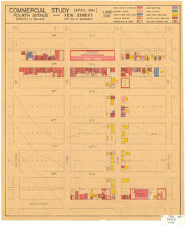
Map is a plan of the area bounded by Balsam Street, 3rd Avenue, Arbutus Street and Broadway, showing streets, blocks and some buildings. Structures are indicated on the plan for Yew Street between Fourth Avenue and Broadway and for Fourth Avenue, between Balsam and Arbutus Street. Structures are hand coloured to indicate land use, such as single family dwellings or business offices. Plan is labelled " K, 1961 April, 3941B, small."

Part of City of Vancouver fonds
Map is a plan of the area bounded by Balsam Street, 3rd Avenue, Arbutus Street and Broadway, showing streets, blocks, lots and legal descriptions. Lots along Fourth Avenue are hand coloured to indicate the period of erection of the structures upon them. Also indicated are those buildings over one storey in height and buildings contructed of masonry. Plan is labelled " K, 1961 April, 3942B, small."
Survey presented to the North West Point Grey home Owners' Association. June 1963
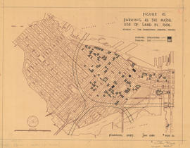
Figure 10 : parking as the major use of land in 1954
Part of City of Vancouver fonds
Map is a plan of downtown Vancouver showing parking structures and parking lots in the area between Jervis Street and Main Street and Burrard Inlet and Nelson Street. The source of the map is indicated as 'The Downtown Parking Report'. Note written in the bottom right corner of the map reads "B 1960 Jan., Traffic Plans, small folder."

Figure 11 : parking as the major use of land in 1959
Part of City of Vancouver fonds
Map is a plan of downtown Vancouver showing parking structures and parking lots in the area between Jervis Street and Main Street and Burrard Inlet and Nelson Street. The source of the map is indicated as an aerial photograph taken April 1959. Note written in the bottom right corner of the map reads "B 1960 Jan., Traffic Plans, small folder."

Figure 12 : parking as the major use of land in 1976
Part of City of Vancouver fonds
Map is a plan of downtown Vancouver showing parking structures and parking lots in the area between Jervis Street and Main Street and Burrard Inlet and Nelson Street. The source of the map is indicated as 'parking supply and demand projections, September 1959'. Note written in the bottom right corner of the map reads "B 1960 Jan., Traffic Plans, small folder."

Figure 15 : a circulation pattern for pedestrians
Part of City of Vancouver fonds
Map is a plan of downtown Vancouver with areas shaded to indicate streets, squares, malls and arcades, in which the movement of vehicles is not permitted at all or is restricted. Although the entire downtown area is shown, shading pertains only to Jervis Street and Main Street and Burrard Inlet and Nelson Street. Note written in the bottom right corner of the map reads "B 1960 Jan., Traffic Plans, small folder."
Granville waterfront interchange
Part of Co-op Radio fonds
Item is an audio reel containing a recording of a program about protests and land claims related to Lyell Island. The first five minutes of the tape are an interview with John about shipyards and union organizing. Description on tape: "Jerome Twin Rainbow ; Lyell Haida Perspective."
Land use : Semlin Drive to Nanaimo Street and Burrard Inlet to Triumph Street
Part of City of Vancouver fonds
Item is a map annotated to show residential, commercial and industrial land use. Base map shows streets, legal addresses, and waterfront businesses in the area from Clark Drive to Slocan Street and Burrard Inlet to Powell Street/Triumph Street.
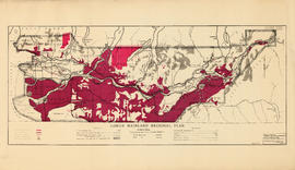
Lower Mainland Regional Plan : land use
Part of Community Planning Association of Canada, British Columbia Division fonds
![[Man and woman looking at a drawing of a proposed civic centre site]](/uploads/r/null/2/7/27f1c8bd2d8d7122baf0e798075bbaa43e488bd8ae519b18893bbaa885546967/b083af49-fc11-43e2-8374-b354f64f6306-A13126_142.jpg)
[Man and woman looking at a drawing of a proposed civic centre site]

Project 2 area "h" and part of "b" : identification plan
Part of City of Vancouver fonds
Item is a map created to show the boundaries of redevelopment areas "b" and "h" in Project 2 and Project 2 clearance areas 8 & 9. The map also shows City-owned property, Adjacent lots in same ownership, as well as property, streets and lanes be acquired for the project. The portion of the City depicted in the map is the area between Main Street and Clark Drive and between Evans Avenue and 10th Avenue (D.L.200, D.L. 264A, D.L. 301, and D.L. 2037).
![Site for Pender St. Freight Sheds [Proposed CPR warehouse site]](/uploads/r/null/c/9/c98fbf881beb24751e22d4a29ef8dafbc64384308780d7650b102a840d3ec9cf/2b82a78b-d54c-4439-a722-0a91a3254cb1-A49474_142.jpg)
Site for Pender St. Freight Sheds [Proposed CPR warehouse site]
Part of H.A. Price collection
Photograph shows land near Pender and Hastings Streets. Image includes railsiding, shed, and buildings in the distance.
The City Seminar : Land use, What Controls are Needed?
Part of Co-op Radio fonds
Item is an audio reel containing a recording of a seminar co-presented by the Community Planning Association and the UBC Centre for Continuing Education. The session was on the topic 'Land Use: What Controls are Needed?' and was chaired by John Olson. The seminar included presentations by James Lorimer, Kent Gereke and Stephen Scheck of the Montreal Citizens Movement.
The effects of rezoning on property values in the city of Vancouver
![[Two men looking at a drawing for a proposed civic centre site]](/uploads/r/null/7/3/736c5cb76b030d42873b8de69f0154afae0e2cf30ee8bc9accbb790f9d5fd095/a082eeba-1928-4634-b546-ecbdff2e11b6-A13127_142.jpg)
[Two men looking at a drawing for a proposed civic centre site]
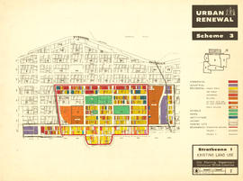
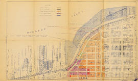
Urban renewal scheme 3 : Strathcona I : existing land use
Part of City of Vancouver fonds
Map is a plan showing streets, blocks and lots in the area bounded by Columbia Street, Burrard Inlet, Glen Drive and Atlantic Street. The map is hand coloured to show the different types of land use in the area between Columbia Street and Glen Drive and Atlantic Street and Hastings Street. Red tape is used to identify the boundaries of the Strathcona sub-area and Project 1 and Project 2 areas are also indicated.

Part of City of Vancouver fonds
Map is a plan showing streets, blocks, lots and structures in the area just west of Main Street to just east of Glen Drive and from Burrard Inlet in the north to Prior Street in the south. The map is hand coloured to show the condition of non-residential buildings from very good to very poor, and areas that are mixed residential and non-residential, in the area bounded by Main Street, Hastings Street, Glen Drive and Prior Street, based upon a 1957 field survey. Also included are the names of businesses along the waterfront.

Urban renewal scheme 3 : Strathcona I & portion of Highway 6 : condition of residential buildings
Part of City of Vancouver fonds
Map is a plan showing streets, blocks, lots and structures in the area just west of Main Street to just east of Glen Drive and from Burrard Inlet in the north to Prior Street in the south. The map is hand coloured to show the condition of residential buildings from very good to very poor in the area bounded by Main Street, Hastings Street, Glen Drive and Prior Street, based upon a 1957 field survey. Also included are the names of businesses along the waterfront.
![Vancouver Clearing [Cleared land in east Vancouver]](/uploads/r/null/5/1/51327e689af024dd93fd7bdeb7d046ed928e250796e9e616bd6fdce26cad21b1/cf5f040a-54e8-417c-8684-7af121a25518-A49471_142.jpg)
Vancouver Clearing [Cleared land in east Vancouver]
Part of H.A. Price collection
Photograph shows recently cleared land in east Vancouver. The North Shore Mountains are in the distance.
![Vancouver Town Planning Commission 1926 [,] Ex-Officio Members [and] Town Planning Consultants](/uploads/r/null/6/2/62e77655e9be887a4ff510f2ec2e3819348e2c62c94f4c12166f1e55004fd864/d33f08ec-6db2-4edb-8617-018c52fc1ee9-A31901_142.jpg)
Vancouver Town Planning Commission 1926 [,] Ex-Officio Members [and] Town Planning Consultants
Part of Major Matthews collection
People identified (left to right): Top row: W. Deptford, W.A. Clark, Wm. Elgie Bland, Mrs. A.M. McGovern, Arthur G. Smith, W.G. Swan, J.W. Allan, G.L. Thornton Sharp, A.E. Foreman, Second row: G.H. Kirkpatrick, A.L. McWilliams, Mayor L.D. Taylor, E.A. Cleveland, E.G. Baynes Bottom row: Horace L. Seymour, L.D.T. Horn, Harland Bartholomew, Earl O. Mills, Wm. D. Hudson, J. Alexander Walker
Will this be your backyard? Will this be your street?