


Title and statement of responsibility area
Title proper
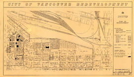
Urban renewal - redevelopment projects no. 1 & 2 maps
General material designation
- Cartographic material
Parallel title
Other title information
Title statements of responsibility
Title notes
Level of description
File
Reference code
Edition area
Edition statement
Edition statement of responsibility
Class of material specific details area
Statement of scale (cartographic)
Scales vary.
Statement of projection (cartographic)
Statement of coordinates (cartographic)
Statement of scale (architectural)
Issuing jurisdiction and denomination (philatelic)
Dates of creation area
Date(s)
Physical description area
Physical description
34 maps
Publisher's series area
Title proper of publisher's series
Parallel titles of publisher's series
Other title information of publisher's series
Statement of responsibility relating to publisher's series
Numbering within publisher's series
Note on publisher's series
Archival description area
Name of creator
Administrative history
The Planning Department was established on November 1, 1952 with the appointment of the Director of Planning, further to the July 1951 report commissioned by City Council from town planning consultants Harold Spence-Sales and John Bland (PD 335). The report had proposed that the Vancouver Town Planning Commission hand over the work intensive and detailed aspects of planning but maintain the advisory role to City Council (renamed Vancouver City Planning Commission in 1972). Those aspects were taken on by the new Planning Department, while the more substantial Zoning By-law interpretation and exception decision-making, as well as the broader aspects of city planning were carried out by a committee of relevant senior staff and officials, which was called the Technical Planning Board. The Board was chaired by the Director of Planning.
Previous to the establishment of the Planning Department in 1952 the Town Planning Commission was responsible for city planning (1926-1952). The earliest town planning or city planning activity was carried out under the authority of City Council, in conjunction with the Board of Works, and the Engineering Department (1886-1926).
Custodial history
Scope and content
File consists of maps created as part of the urban renewal program's redevelopment project no. 2.
Notes area
Physical condition
Immediate source of acquisition
Arrangement
At the time or original accessioning, maps were alienated from their original project files and added to AM1594 City of Vancouver Archives technical and cartographic drawing collection. They have been returned to the appropriate Planning Department series.