A. Williams residence : University Endowment Lands [5853 NW Marine Drive?]
- AM755-F262
- File
- 1947
Part of C.B.K. Van Norman fonds
File consists of the following types of architectural drawings: elevations, floor plans and structural specifications.
41 results directly related Exclude narrower terms
A. Williams residence : University Endowment Lands [5853 NW Marine Drive?]
Part of C.B.K. Van Norman fonds
File consists of the following types of architectural drawings: elevations, floor plans and structural specifications.

Aerial photo, vertical, University of British Columbia and University Endowment Lands
![[Aerial photograph of University of British Columbia Endowment Land area, showing some farm land]](/uploads/r/null/7/0/70e1f604470000e7a05baa46d299f27cb13e52173626249485a3a2586cb9f054/90b2a170-3763-41e7-a2ac-edba3984d880-A72733_142.jpg)
[Aerial photograph of University of British Columbia Endowment Land area, showing some farm land]
Part of Dunbar History Project fonds
Item filed under People and customs. Image shows Department of Agriculture farm.
Alterations and additions to E.C. McDougall residence : 1416 Acadia Road
Part of C.B.K. Van Norman fonds
File consists of the following types of architectural drawings: cross sections, floor plans, additions and alterations and structural specifications.
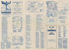
Dial map of the city of Vancouver including the adjacent municipalities
Part of City of Vancouver Archives technical and cartographic drawing collection
Item is a street map showing Vancouver, Burnaby, New Westminster, West Vancouver and North Vancouver on one side and the University Endowment Lands, Surrey, Maillardville, Lulu Island and Sea Island on the other.
Dial map of the city of Vancouver including the adjacent municipalities
Item is a street map showing Vancouver, Burnaby, New Westminster, West Vancouver and North Vancouver on one side and the University Endowment Lands, Surrey, Maillardville, Lulu Island and Sea Island on the other.
Fourth Avenue connection (University Endowment Lands, B.C.)
Fourth Avenue connection (University Endowment Lands, B.C.)
Part contains street maps of the University Endowment Lands, Surrey, Maillardville, Lulu Island and Sea Island, tourist information about Vancouver, and text advertising the products and services of the Dominion Map and Blueprint Company.

Part of City of Vancouver Archives technical and cartographic drawing collection
Part contains street maps of the University Endowment Lands, Surrey, Maillardville, Lulu Island and Sea Island, tourist information about Vancouver, and text advertising the products and services of the Dominion Map and Blueprint Company.
Item is a brochure for the preservation of the Endowment Lands.
Mr. & Mrs. Coley Hall residence : [5687 Chancellor Blvd.?]
Part of C.B.K. Van Norman fonds
File consists of the following types of architectural drawings: elevations, floor plans and details.
Mr. & Mrs. G.W. Dill residence : 1807 Acadia Road, University Endowment Lands
Part of C.B.K. Van Norman fonds
File consists of the following types of architectural drawings: elevations, floor plans and structural specifications.
Mr. & Mrs. McLeod residence : Lot 1 Blk 70 Unit 2, U.E.L. [5840 Newton Wynd]
Part of C.B.K. Van Norman fonds
File consists of the following types of architectural drawings: elevations, floor plans and structural specifications.
Mr. Buckley residence alterations : [1690 Western Parkway?], University Endowment Lands
Part of C.B.K. Van Norman fonds
Item consists of a drawing of an ornamental detail.
Mrs. Hamilton Baker residence : University Endowment Lands
Part of C.B.K. Van Norman fonds
File consists of the following types of architectural drawings: floor plans and structural specifications.
Part of C.B.K. Van Norman fonds
File consists of the following types of architectural drawings: elevations, floor plans and structural specifications.
Mrs. W.O. Wright residence : Lot 11 Blk 71 D.L. 140 (5511 Chancellor Blvd?)
Part of C.B.K. Van Norman fonds
File consists of the following types of architectural drawings: elevations, floor plans and structural specifications.
Mrs. W.O. Wright residence : Lot 11 Blk 71 D.L. 140 (5511 Chancellor Blvd?)
Part of C.B.K. Van Norman fonds
File consists of the following types of architectural drawings: elevations, floor plans and structural specifications.
Mrs. W.O. Wright residence : Lot 11 Blk 71 D.L. 140 (5511 Chancellor Blvd?)
Part of C.B.K. Van Norman fonds
File consists of the following types of architectural drawings: elevations, floor plans, structural specifications and plot plans.
O. Hanson residence : Lot 9 Blk 68 D.L. 140 [1484 Acadia Road]
Part of C.B.K. Van Norman fonds
File consists of the following types of architectural drawings: elevations, floor plans and structural specifications.
Phi Gamma Delta fraternity house : Lot 6 Blk 83 Unit 1 U.E.L. [1882 Western Parkway?]
Part of C.B.K. Van Norman fonds
File consists of the following types of architectural drawings: elevations, floor plans and structural specifications.
Plan : South West Marine Drive (University Endowment Lands, B.C.)
Plan of unit no. 1 : housing development between Chancellor Blvd. and Agronomy Road
Plan of unit no. 2 land development north of Chancellor Blvd.
Part of C.B.K. Van Norman fonds
Item consists of the following types of architectural drawings: elevations, floor plans and additions and alterations.
Save the UBC Farm : join the trek
Save UBC Farm : as it is : as it should be : join the great farm trek
Informational brochure promoting the campaign to save UBC Farm. "Saving the Farm means protecting and supporting the farm's social, ecological, and educational systems . . . " and advertising the "Great Farm Trek," April 7th, 2009.
![[The last Spanish exploration - Historic Site and Monuments Board of Canada monument]](/uploads/r/null/7/2/a/72a3937c686e9bd484c592e1e6a4389a5d3a7285f049b4000886b1c5f6778c1f/d54612a7-d7da-4ebc-8170-6514bdc5ec3f-CVA1095-01082_142.jpg)
[The last Spanish exploration - Historic Site and Monuments Board of Canada monument]
Part of City of Vancouver fonds
Item is a photograph showing a plaque and monument located on Northwest Marine Drive.
![[The last Spanish exploration - Historic Site and Monuments Board of Canada plaque]](/uploads/r/null/1/a/4/1a42dfc3b8e87a65a11d0d1110d245ab06ade80a59d37f918aa515458b2cfdab/4a127ad1-c6fb-4285-ade9-f0b5965ab2b6-CVA1095-01081_142.jpg)
[The last Spanish exploration - Historic Site and Monuments Board of Canada plaque]
Part of City of Vancouver fonds
Item is a photograph showing a plaque on a monument located on Northwest Marine Drive.
U.E.L. (University Endowment Lands) Point Grey
U.E.L. (University Endowment Lands) Point Grey, B.C.

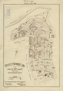
University Endowment Lands : plan of units no. 1 and 2
Part of City of Vancouver Archives technical and cartographic drawing collection
Item is a map showing streets, land subdivision, properties disposed of, and buildings in the University Endowment Lands north of University Boulevard. Additional blocks have been filled in by hand, likely by J.S. Matthews.

University Endowment Lands : plan of units nos. 1 and 2
Part of City of Vancouver Archives technical and cartographic drawing collection
Item is a map showing streets, land subdivision, properties disposed of, and buildings in the University Endowment Lands north of University Boulevard. Telephone numbers have been changed, issuing date added, and additional blocks filled in by hand, likely by J.S. Matthews.
University Endowment Lands : plan of units nos. 1 and 2
Part of City of Vancouver Archives technical and cartographic drawing collection
Item is a map showing streets, land subdivision, properties disposed of, and buildings in the University Endowment Lands north of University Boulevard. Additional blocks have been filled in by hand, likely by J.S. Matthews.
University Endowment Lands - Point Grey, B.C.
University Endowment Lands - Point Grey, B.C.
University Endowment Lands - Point Grey, British Columbia
University Endowment Lands - Point Grey, British Columbia
University Endowment Lands - UBC
University Endowment Lands - UBC