- PUB-: PD 2112
- Item
- 1989
Part of City publications collection
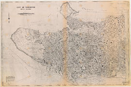
Item is a map showing streets, address block numbers, parks, schools, golf courses, First Nations reserves, railways, and topographic contour lines.
5 results directly related Exclude narrower terms
Part of City publications collection
Item is a map showing streets, address block numbers, parks, schools, golf courses, First Nations reserves, railways, and topographic contour lines.
Contour plan of a portion of the City of Vancouver
Part of City of Vancouver fonds
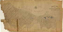
Item is a map of the area from Chilco Street to Raymur Avenue and Coal Harbour/Vancouver Harbour to False Creek showing topographic contour lines, streets, block numbers (in Roman numerals), sewers, manholes, and elevations at various points along streets.
Map of city of Vancouver, British Columbia
Map shows streets, schools, hospitals, street car lines, railways and block numbers in the city of Vancouver. Street index on verso.

Vancouver sheet, British Columbia
Part of City of Vancouver Archives technical and cartographic drawing collection
Item is a map of Vancouver Island and the southwest portion of mainland British Columbia from Bella Coola to Clinton, and south to New Westminster. Map shows geological, land district, and park boundaries; locations of mining recording offices and sub-offices; elevations in feet above sea level; mineral occurrences; and the development of geological formations by era.

Part of City of Vancouver Archives technical and cartographic drawing collection
Item is a topographical map showing lands alienated or covered by application under the Land Act, timber leases, native reserves, government reserves, and various boundaries, as well as campsites, picnic sites, forest service lookouts, post offices, settlements, schools, hospitals, mines, dykes, historic monuments, roads, trails, railways, power lines, phone lines, air harbour or seaplane anchorages, etc. Sheet contains an index map showing adjoining maps in the series.