Item : PAM 1936-153 - Sectional map and street directory of Vancouver

Sectional map and street directory of Vancouver : cover page Sectional map and street directory of Vancouver : introduction to map Sectional map and street directory of Vancouver : street directory Sectional map and street directory of Vancouver : street directory Sectional map and street directory of Vancouver : street directory Sectional map and street directory of Vancouver : street directory Sectional map and street directory of Vancouver : street directory Sectional map and street directory of Vancouver : street directory Sectional map and street directory of Vancouver : street directory Sectional map and street directory of Vancouver : street directory Sectional map and street directory of Vancouver : street directory Sectional map and street directory of Vancouver : key plan Sectional map and street directory of Vancouver : [Carrall Street to Lost Lagoon to Beach Avenue ... Sectional map and street directory of Vancouver : [Willingdon Avenue to Wall Street to Ontario St... Sectional map and street directory of Vancouver : [North Road to Barnet Road to Sperling Avenue t... Sectional map and street directory of Vancouver : [Ontario Street to King Edward Avenue to East B... Sectional map and street directory of Vancouver : [Boundary Road to King Edward Avenue to Nanaimo... Sectional map and street directory of Vancouver : map of West Vancouver Sectional map and street directory of Vancouver : map of Lulu Island Sectional map and street directory of Vancouver : [Brunette Road to Avalon Avenue to Griffiths Ro... Sectional map and street directory of Vancouver : map of Stanley Park Sectional map and street directory of Vancouver : index to maps Sectional map and street directory of Vancouver : street directory Sectional map and street directory of Vancouver : street directory Sectional map and street directory of Vancouver : street directory Sectional map and street directory of Vancouver : street directory Sectional map and street directory of Vancouver : street directory Sectional map and street directory of Vancouver : street directory Sectional map and street directory of Vancouver : street directory Sectional map and street directory of Vancouver : street directory Sectional map and street directory of Vancouver : [Imperial Street to N.W. Marine Drive to West M... Sectional map and street directory of Vancouver : [Nanaimo Street to Alexander Street to Ontario ... Sectional map and street directory of Vancouver : [Sperling Avenue to Yale Street to Boundary Roa... Sectional map and street directory of Vancouver : [West Boulevard to King Edward Avenue to Bounda... Sectional map and street directory of Vancouver : [King Edward Avenue to Ontario Street to Fraser... Sectional map and street directory of Vancouver : [Taylor Road to Coleman Street to Capilano Rive... Sectional map and street directory of Vancouver : [Griffiths Avenue to Eglinton Street to Joffre ... Sectional map and street directory of Vancouver : [McBride Boulevard to Laburnum Street to Eighte...

Title and statement of responsibility area

Title proper

Sectional map and street directory of Vancouver

General material designation

  • Textual record
  • Cartographic material

Parallel title

Other title information

Title statements of responsibility

Title notes

Level of description

Item

Reference code

AM1519-: PAM 1936-153

Edition area

Edition statement

Fourth edition

Edition statement of responsibility

Class of material specific details area

Statement of scale (cartographic)

Statement of projection (cartographic)

Statement of coordinates (cartographic)

Statement of scale (architectural)

Issuing jurisdiction and denomination (philatelic)

Dates of creation area

Date(s)

Physical description area

Physical description

1 map, 39 p. ; 17 x 25 cm, folded to 17 x 12.5 cm

Publisher's series area

Title proper of publisher's series

Parallel titles of publisher's series

Other title information of publisher's series

Statement of responsibility relating to publisher's series

Numbering within publisher's series

Note on publisher's series

Archival description area

Custodial history

Scope and content

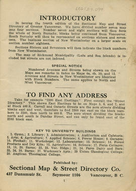
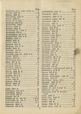
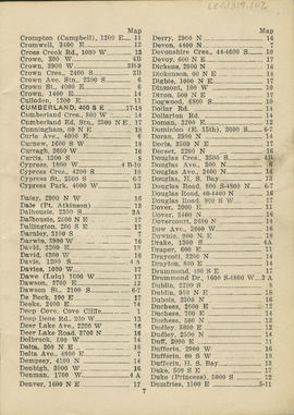
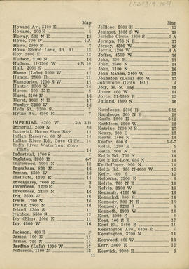
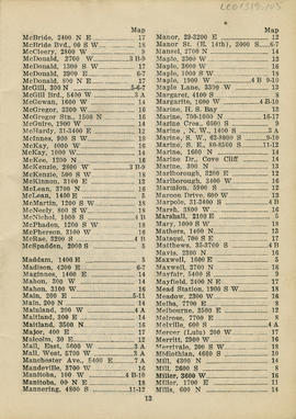
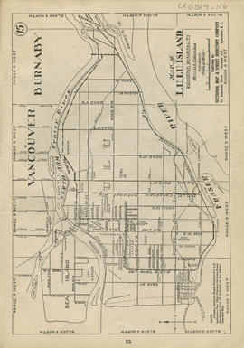
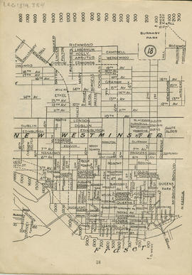
Item is a sectional map and street directory of Vancouver, includes Burnaby, New Westminster, North Vancouver, West Vancouver, Lulu Island and Sea Island. The map contains a street directory in alphabetic order with associated map locations and a key plan to the map.

Notes area

Physical condition

Dirt on pages throughout map booklet

Immediate source of acquisition

Arrangement

Language of material

Script of material

Location of originals

Availability of other formats

Restrictions on access

Terms governing use, reproduction, and publication

Finding aids

Associated materials

Related materials

Accruals

Rights

Public domain

Alternative identifier(s)

Standard number area

Standard number

Access points

Subject access points

Place access points

Name access points

Genre access points

Rights area

Accession area

Related subjects

Related people and organizations

Related places

Related genres

Container name

  • Box: 631-G-04