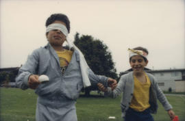
Children participating in relay race
- AM1576-S6-12-F18-: 2011-010.2461-: 2011-010.2461.22
- Part
- [June 21 or June 22] 1986
1697 results directly related Exclude narrower terms
Children participating in relay race
![[Children wading in the pond at Bowser (Maple Grove) Park]](/uploads/r/null/9/b/9bdc925e80d8e8df2394aec9d7ca02bb96da5026c0a00057334dab1bd9e4dbda/33e1283d-2c61-4ab0-b836-66948076d7b6-A34160_142.jpg)
[Children wading in the pond at Bowser (Maple Grove) Park]
Part of Major Matthews collection

City Magazine : July 1978 : vol. 3 : no. 6
Includes article "Vancouver Waterfront tug-o-war" regarding the proposed Four Seasons Hotel development and the All Seasons Park people's protest of 1971.

Item is a documentary film documenting people participating in recreational activities in Montreal?s parks. Some of the recreational activities documented in the film include children?s playground activities, a parade, races, baseball, tug-of-war, swimming, gymnastics, ice-skating, hockey and a toboggan run.

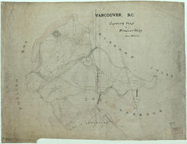
Part of City of Vancouver Archives technical and cartographic drawing collection
Map is a City Engineering Department base map of Vancouver, showing city blocks and Canadian Pacific, Canadian National and Great Northern Railway lines. Parks, golf courses, hospitals, schools, theatres and other structures are identified. "Metric Vancouver" and "Guide Map 15" appear in the bottom right corner of the map.

Part of City of Vancouver Archives technical and cartographic drawing collection
Map is a City Engineering Department base map of Vancouver, showing city blocks and Canadian Pacific, Canadian National and Great Northern Railway lines. Parks, golf courses, hospitals, schools, theatres and other structures are identified. "Guide Map 15" appears in the bottom right corner of the map.
![City of Vancouver [park sites June/80]](/uploads/r/null/9/4/9484add7c4684ea3838e4d00ee8add3ecf85d78d5aa8fe2780cae273e59556a5/bd2464d8-2aa9-4501-aba6-8b3f7d130a42-MAP1032_142.jpg)
City of Vancouver [park sites June/80]
Part of City of Vancouver Archives technical and cartographic drawing collection
Map is a City Engineering Department base map of Vancouver, with parks hand-coloured in green. Shows city blocks and Canadian Pacific, Canadian National and Great Northern Railway lines. Golf courses, hospitals, schools, theatres and other structures are identified. "Metric Vancouver" and "Guide Map 15" appear in the bottom right corner of the map.

City of Vancouver, British Columbia
Part of City of Vancouver Archives technical and cartographic drawing collection
Item is the western half of a map showing city blocks, transportation infrastructure, recreational facilities, hospitals, schools, theatres and other structures are identified. MAP 1036 is the eastern half of this map.
Vancouver (B.C.). Engineering Services

City of Vancouver, British Columbia
Part of City of Vancouver Archives technical and cartographic drawing collection
Item is the eastern half of a map showing city blocks, transportation infrastructure, recreational facilities, hospitals, schools, theatres and other structures are identified. MAP 1036b is the western half of this map.
Vancouver (B.C.). Engineering Services

City of Vancouver, British Columbia : co-ordinate street index map 12
Part of City of Vancouver Archives technical and cartographic drawing collection
Map is City Engineering Department base map 149 of the City of Vancouver, showing city blocks, streets and railway lines, as well as the area code co-ordinates assigned by the department. Golf courses, hospitals, schools, theatres and other structures are also identified.
City of Vancouver, Vancouver, British Columbia : sectional maps
Part of City of Vancouver Archives technical and cartographic drawing collection
File consists of three maps of Vancouver: an index to the sectional map sheets, a plan of District Lots in Vancouver, and a sectional map in 62 sheets. The sectional map sheets show streets and roads, blocks, lots, legal descriptions, railways, parks, schools, hospital, cemetery, golf courses, retirement homes, and some businesses.
Vancouver (B.C.). Office of the City Engineer
![[Cityscape of Kitsilano looking North]](/uploads/r/null/2/0/20a1900669c168d04ff275a3805145786dc47a4943e313105af3e5000e9617fc/af1fdd04-91e0-4295-a233-74504a743335-A58955_142.jpg)
[Cityscape of Kitsilano looking North]
Part of City of Vancouver fonds
Photograph also shows the North Shore and Stanley Park

Clarence Park, Weston-Super-Mare
This postcard includes personal correspondence addressed to Miss Hilda Baggs of Bath.
Part of City of Vancouver fonds

Part of City of Vancouver fonds
Part of City of Vancouver fonds

Part of City of Vancouver fonds
Part of City of Vancouver fonds
Item is photograph showing an aerial view of Stanley Park and Coal Harbour.

Item is photograph showing an aerial view downtown Vancouver looking northwest towards Coal Harbour and Stanley Park.

Item is photograph showing an aerial view downtown Vancouver looking northwest towards Coal Harbour and Stanley Park.
Item is photograph showing an aerial view downtown Vancouver looking northwest towards Coal Harbour and Stanley Park.
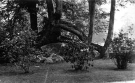
Cleared area with shrubs around maple trees in Stanley Park
Part of Samuel H. Logan fonds
![[Coal Harbour and downtown Vancouver]](/uploads/r/null/9/6/963211ebd8afe965840840d585cec1a2b8ebc9fa5ccad89c0d8ff6fa5b09b325/aae76ee7-a000-4d73-be7e-1831535a08b6-CVA1435-630_142.jpg)
[Coal Harbour and downtown Vancouver]
Item is photograph showing Coal Harbour and downtown Vancouver, taken from the Stanley Park causeway.
![[Coal Harbour and downtown Vancouver]](/uploads/r/null/9/2/924cd84f7afa829f5183160b8a807996bf9c4e5c5aa58f8a386bfce3eb7e665a/d60e2151-8687-4709-b421-fc93e2bcfce5-CVA1435-632_142.jpg)
[Coal Harbour and downtown Vancouver]
Item is photograph showing Coal Harbour and downtown Vancouver, taken from the Stanley Park causeway.
![[Commemorative plaque, Stanley Park]](/uploads/r/null/1/a/0/1a009ca90ba034f46955606fdb2b2502562be62dccb0d81a5e242d804e633831/8bdae819-ba1d-42e7-b68a-c7d25cac16ee-CVA1095-00664_142.jpg)
[Commemorative plaque, Stanley Park]
Part of City of Vancouver fonds

Commercial map of Greater Vancouver and district
Part of City of Vancouver Archives technical and cartographic drawing collection
Item is a map sheet containing two maps. The principal map depicts greater Vancouver, including portions of North and West Vancouver, Richmond and Surrey. The information depicted on the map includes streets, postal blocks, streetcar and railway lines, parks and golf courses, and schools. The map includes 1/2 mile distance circles centred on old City Hall at Main and Hastings.
The sheet includes an inset map of Granville Island. Depth of water given along shorelines of Burrard Inlet, English Bay, and along the West Vancouver coast from First Narrows to Howe Sound. The sheet includes an index of streets.
![[Composite of three Vancouver scenes]](/uploads/r/null/6/3/63a212dcbeefd621100706d8f124b87a33a6c9b89b843c22e400d20998580f4b/0a7256b5-202a-467c-a84e-a7798851caef-A03937_142.jpg)
[Composite of three Vancouver scenes]
Part of Major Matthews collection
Photograph consists of a composite of three photographs, showing a salmon cannery, Brockton Point, and a view of Vancouver from Mount Pleasant. The images were photographed while mounted on a sheet of newspaper.
![[Composite view of ships and Stanley Park sites]](/uploads/r/null/3/c/3c46b96242786e4b1aad8df2b667da89143a46e55dc4a60c9541d68888ae6ac9/d6361a9b-8768-494b-911e-6f055c94677c-A03966_142.jpg)
[Composite view of ships and Stanley Park sites]
Part of Major Matthews collection
Photograph consists of a composite of four photographs showing: large tree in Stanley Park, bridge in Stanley Park, the S.S. "Beaver" on shore (Bo P124), and the "Empress of India" at Vancouver dock (Bo P 6.4).
![Conference kids [10 of 23]](/uploads/r/null/b/7/4/b747e6bbb1147c1bc832e8037f755c17aca67c836ce3be70865a1fa2842a807e/fb5a9c26-9303-4470-80a6-a148d8e392de-2011-130_142.jpg)
Part of Habitat Forum photographs
![Conference kids [11 of 23]](/uploads/r/null/5/6/3/563f27030b064ed34cbc2642494cf2d668fc8f4dd23b44fdbce2c8ae0e486c52/52df057f-8e86-49d4-b555-1d20828988ea-2011-130_142.jpg)
Part of Habitat Forum photographs
![Conference kids [12 of 23]](/uploads/r/null/6/1/d/61d08385d51848966e6b1ce54257937c836ba54b4ba4321174da23872aa5bcd4/ea410ce4-75dc-4761-a725-213d87d7918f-2011-130_142.jpg)
Part of Habitat Forum photographs
![Conference kids [13 of 23]](/uploads/r/null/3/b/0/3b0a2fab358c1504765795baaa24fb5d489e0fa28e15f674c0b47c6d15a51d36/41fda8f8-eb84-40cf-8604-464a5c87fa31-2011-130_142.jpg)
Part of Habitat Forum photographs
![Conference kids [14 of 23]](/uploads/r/null/2/8/8/288eb86745506edc5f1420a3a5b5b4008b94e0a86a830c62f6011547deb180c5/52861368-f6e9-450e-a131-f087bab44902-2011-130_142.jpg)
Part of Habitat Forum photographs
![Conference kids [15 of 23]](/uploads/r/null/8/7/7/877e3ccfb8aedc27f5217636444cdc6d565a719d2ec7c875ccfad066450befae/12688ca4-6398-4a90-b8a5-0539f368f9ed-2011-130_142.jpg)
Part of Habitat Forum photographs
![Conference kids [16 of 23]](/uploads/r/null/2/6/4/264c0ab919384bf4878a4962354ec01f948deb9a70a43ba9ebd35de35039e137/487863b2-cc56-4378-9571-c05f6c3b67be-2011-130_142.jpg)
Part of Habitat Forum photographs
![Conference kids [17 of 23]](/uploads/r/null/7/8/0/78060fcd507daf3f2d976216a6b6aad7eea496c7a09288691dc282ad2604fed9/66c67dfb-550d-485e-8f38-2331ee647c5c-2011-130_142.jpg)
Part of Habitat Forum photographs
![Conference kids [18 of 23]](/uploads/r/null/1/7/6/1762527db8a7d195052fd1a4af4fdb8b1871d4b9bd47efd33b8f31b68ec8f2d8/ff83a58b-8ca7-4e31-9f1e-1a81e705ab4b-2011-130_142.jpg)
Part of Habitat Forum photographs
![Conference kids [20 of 23]](/uploads/r/null/b/b/6/bb6aa00b0d611f7aa0ed155ddceef0f62df344e96bdcbf72b302743d501e3722/647e576d-9e7f-4646-9de8-f5964fd58631-2011-130_142.jpg)
Part of Habitat Forum photographs
![Conference kids [21 of 23]](/uploads/r/null/b/5/f/b5fb13b60cc2c1bd8c143b4e46e143f489c52d7f03484e6ddfcccaa8f6befd8c/bd2676d1-267f-47ac-85f9-eceadd6800c4-2011-130_142.jpg)
Part of Habitat Forum photographs
Part of Major Matthews collection

Connaught Park - 12th Avenue landscaping
Part of City of Vancouver fonds
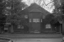
Connaught Park Field House, 2390 West 10th Avenue
Part of City of Vancouver fonds

Connaught Park Field House, 2390 West 10th Avenue
Part of City of Vancouver fonds
![[Construction of the Dedicated Fire Protection System Kitsilano extension in Vanier Park]](/uploads/r/null/6/5/654eb969bf0acc791a1f74b8115765c2b5f26111109b0493cb9b829d1a62bb5e/db3f3aee-c718-4c66-9712-5523a45f3578-CVA1376-43_142.jpg)
[Construction of the Dedicated Fire Protection System Kitsilano extension in Vanier Park]
Photograph shows the 1200 and 1300 blocks of Chestnut Street, the Vancouver Museum and the DFPS pipeline laid out in the park during construction.
![[Construction of the Dedicated Fire Protection System Kitsilano extension in Vanier Park]](/uploads/r/null/b/5/b5cf3880be1cdc714e93bb9ed0fd9cd2e3c1eda6bc065aba1212da232c58acea/c546f069-a0a0-4817-97e6-d4e3e9f21598-CVA1376-43_142.jpg)
[Construction of the Dedicated Fire Protection System Kitsilano extension in Vanier Park]
Photograph shows the Vancouver Museum and parking lot, part of the Gordon MacMillan Southam Observatory, the DFPS pipeline, bulldozer and excavation machinery.
Part of City of Vancouver fonds
Item is a topographical map of Stanley Park showing various landmarks and locations of buildings.
Vancouver (B.C.). Engineer's Office
![Corner Dunlevy [Avenue] and Powell [Street] Oppenheimer Park](/uploads/r/null/5/e/5e2c24ea07e01c23c25892784877e9a3be5d15b8555f00e28611a49c07704b64/f536c908-7c91-416d-bccb-8e97f2719fb0-A59237_142.jpg)
Corner Dunlevy [Avenue] and Powell [Street] Oppenheimer Park
Part of City of Vancouver fonds
Photograph also shows Wings Hotel (143 Dunlevy Avenue)
Part of City of Vancouver fonds