- AM358-: MAP 681
- File
- [before July 6, 1909]
Part of H.A. Price collection
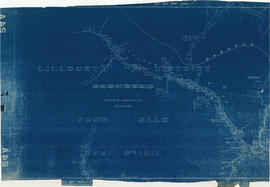
Item is a sectional map showing the Eburne [Marpole] tyo New Westminster branch line of the Vancouver and Lulu Island Railway. The map also shows District Lot lot numbers and names associated with properties adjacent to the line.
Canadian Pacific Railway Company. Engineering Office


![Map of the business portion of the City of Vancouver, British Columbia [early street paving]](/uploads/r/null/7/1/7187f671d2770050eb87f7f397a10ea92bf0bc593b0a186e3a4bf341b3d26e42/8770145a-b925-4eef-82ac-e397f61a65aa-Map1163_142.jpg)
