
- AM1594-: MAP 333
- Item
- [1909?]
Part of City of Vancouver Archives technical and cartographic drawing collection
Item is a map showing lots for sale in the Grandview District.
289 results directly related Exclude narrower terms
Part of City of Vancouver Archives technical and cartographic drawing collection
Item is a map showing lots for sale in the Grandview District.

Map of Granville Street, downtown Vancouver
Item is a map showing Granville Street from the Granville Street Bridge over False Creek in the southwest to the train yard and waterfront below Cordova Street in the northeast. Numbered city blocks on either side of the street are depicted, with numbers and occupants' names (including businesses) shown for most of the properties. The location of the publisher's office on Seymour Street is shown.

Item is a map showing district lot, block, and lot numbers, and both current and former street names.
Map of New Westminster District
Part of City of Vancouver Archives technical and cartographic drawing collection
Item is a map showing land subdivision of the entire New Westminster District. Railway lines, lakes, rivers and creeks are also shown.

Map of New Westminster District, B.C
Part of City of Vancouver Archives technical and cartographic drawing collection
Item is a map showing District Lots in Vancouver, and township/range designations in other areas. The map also shows False Creek Trail, North Arm Road, False Creek Road, Granville Road from Granville to Hastings, New Westminster and Burrard Inlet Road, North Road, Semiahmoo Road, New Westminster and Yale Wagon Road, and others. Annotated by W. E. Graveley, 1885, to show additional features including Kingsway, Haney, Albion Camp, etc.

Map of New Westminster District, B.C.
Part of City of Vancouver Archives technical and cartographic drawing collection
Map shows lot numbers and municipal boundaries in the area from Pitt Lake in the north to the United States border in the south and from the municipality of Coquitlam in the east to Point Atkinson in the west.

Map of New Westminster District, B.C.
Part of City of Vancouver Archives technical and cartographic drawing collection
Item is a reprint of a map showing municipalities in the New Wesminster District of 1892 and includes lot numbers.

Map of part of the New Westminster District shewing the proposed new municipality of Burnaby
Part of City of Vancouver Archives technical and cartographic drawing collection
Item is a map showing boundaries of a proposed new municipality of Burnaby, which would include all land outside the "old" City of Vancouver between Burrard Inlet and the Fraser River and west of North Road. The map also shows the boundaries of District Lots in this area.
Garden, Hermon and Burwell, Provincial Land Surveyors
Map of portion of New Westminster District with adjacent islands and part of Vancouver Island
Part of City of Vancouver Archives technical and cartographic drawing collection
Item is a property map which shows timber leasesholds, Indian reserves, districts, and parcels of land.
Map of portion of New Westminster District with adjacent islands and part of Vancouver Island, B.C.
Part of City of Vancouver Archives technical and cartographic drawing collection
Item is a map which shows parts of the east coast of Vancouver Island of southern Vancouver Island, the Strait of Georgia, the Gulf Islands, the Sechelt Peninsula, and Greater Vancouver. The map shows the numbers of the district lots for all of the New Westminster Land District.

Part of City of Vancouver Archives technical and cartographic drawing collection
Item is a map of the municipality of Richmond, showing streets, dykes, railways, swing bridges, churches, schools, post offices, proposed roads, lot numbers and geographical features.
Buckle, C. W.
![Map of the business portion of the City of Vancouver, British Columbia [early street paving]](/uploads/r/null/7/1/7187f671d2770050eb87f7f397a10ea92bf0bc593b0a186e3a4bf341b3d26e42/8770145a-b925-4eef-82ac-e397f61a65aa-Map1163_142.jpg)
Map of the business portion of the City of Vancouver, British Columbia [early street paving]
Part of City of Vancouver Archives technical and cartographic drawing collection
Item is a published map of the Vancouver central business district which has been annotated to show which paving type has been used on certain streets: wood block or bituminous.
Map of the city of Liverpool, Burrard Inlet, British Columbia
Part of City of Vancouver Archives technical and cartographic drawing collection
Item is a copy of a land registry map used to document the registration of block and lot subdivisions in what later became the West End neighbourhood of Vancouver. The original map has been heavily annotated around the map image to record information regarding the individual filings submitted for registration of individual blocks and lots, though the writing is not always legible. The map also shows the boundaries between the lands owned by John Morton, Hailstone and Brighouse, and David Oppenheimer and others, between the original Granville Township and the government reserve that later became Stanley Park.
Turner, George

Map of the Fraser Valley showing railway lines and district lots
Part of City of Vancouver Archives technical and cartographic drawing collection

Map of the Lower Mainland showing municipal boundaries and lot numbers
Part of City of Vancouver Archives technical and cartographic drawing collection
Item is a portion of a map showing municipal boundaries, lot numbers, major roads, railways, bridges and reserves in the Lower Mainland area.

Map of the south-western part of British Columbia
Part of City of Vancouver Archives technical and cartographic drawing collection
Item is a map which depicts the relative locations of various Land Districts and Divisions in south-west British Columbia. The boundaries between the districts are not shown. The map also shows physical features (though not topography) and transportation routes.
Map of Vancouver, B.C. including Hastings Townsite and D.L. 301
Part of City of Vancouver Archives technical and cartographic drawing collection
Item is a map which shows Vancouver city streets, blocks, parks and neighbourhood boundaries. Map includes Kitsilano, Shaughnessy Heights, West End, Fairview, Mount Pleasant, Grandview, Rosedale and Hyde Park areas. Map also indicates steamship, car and railway lines.
The map was originally designed to be folded and enclosed in a small folder to which it was attached.

Map of West Vancouver and vicinity
Part of City of Vancouver Archives technical and cartographic drawing collection
Part contains a map of West Vancouver, North Vancouver, and the northern parts of Vancouver and Burnaby. Map shows district lot and block numbers, streets, and distances from City Hall.
Map of West Vancouver and vicinity
Part of City of Vancouver Archives technical and cartographic drawing collection
Item is a map of West Vancouver, North Vancouver, and the northern parts of Vancouver and Burnaby, with an advertisement for R.P. Matheson Advertising Service and promotional images of West Vancouver on verso. Item appears to have been cut from a larger publication; some images on verso are cut off.

Part of City of Vancouver Archives technical and cartographic drawing collection
![Municipality of North Vancouver [Burrard Inlet]](/uploads/r/null/6/d/6d0d9a4b75b38672c56aa89a5984fe2d0e6d66be85f6f375cbe8e2fd7ac94a98/577914e1-3de2-478b-a629-5f391731387a-MAP588_142.jpg)
Municipality of North Vancouver [Burrard Inlet]
Part of City of Vancouver Archives technical and cartographic drawing collection
Item is a copy of a map showing land subdivision for lands around Burrard Inlet, including North Vancouver and a portion of Vancouver. Major rivers and creeks are identified and the elevation of some mountains are given. The Canadian Pacific Railway from Port Moody to Vancouver is also shown.
Municipality of Point Grey : sale of municipal-owned lands
Part of City of Vancouver Archives technical and cartographic drawing collection
Item is a promotional leaflet advertising properties for sale in Point Grey. One side contains a map showing lots for sale; the other contains text describing the Point Grey area and explaining the conditions of sale.

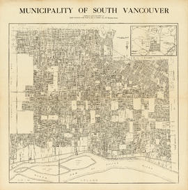
Municipality of South Vancouver
Part of City of Vancouver Archives technical and cartographic drawing collection
Item is a map sheet; the main map shows District Lots, blocks and lots, street addresses, schools, and a cemetery. The inset map shows electric streetcar lines in from Vancouver to New Westminster.

Municipality of South Vancouver
Part of City of Vancouver Archives technical and cartographic drawing collection
Item is a map showing legal addresses, streets and schools in South Vancouver. A small key plan shows the location of the area covered by the primary map in relation to the rest of the Lower Mainland.
Municipality of South Vancouver
Part of McGuigan family fonds
Item is a map showing legal addresses in South Vancouver. An inset map shows the Municipality of South Vancouver in relation to the rest of the Greater Vancouver area.
New Westminster, British Columbia
Part of City of Vancouver Archives technical and cartographic drawing collection
Map shows the portion of New Westminster south of Columbia Street to the Fraser River. Land subdivision for the area is shown and streets are identified. Inset shows the location of New Westminster in relation to the rest of the Lower Mainland, B.C.

North Arm Road, 1876. North Arm, Fraser River
Part of City of Vancouver Archives technical and cartographic drawing collection
Item is an illustrated map showing lot boundaries and numbers, roads, trails, family settlements and reserves along North Arm Road along the shoreline of the North Arm of the Fraser River.
Matthews, James Skitt, Major

Part of D.L. 526 (Vancouver section 29)
Part of City of Vancouver Archives technical and cartographic drawing collection
Item is a sectional plan which shows the area of Kitsilano Point and the adjacent area of Kitsilano south to 1st Avenue in the south and Arbutus Street to the west. The map includes the CPR right of way and harbour headlines, as well as the Vancouver and Lulu Island railway (CPR).
![Part of D.L. [District Lot] 185](/uploads/r/null/d/0/2/d020a729408b2c6caa3fc78d706b687230bf429554ef426ba4dc104ce23d48d6/dbf9611e-8fed-4827-b82a-7e29f4922fc3-MAP904_142.jpg)
Part of D.L. [District Lot] 185
Item is section 4 of a City of Vancouver Surveys Branch sectional plan of Vancouver. Item shows area bounded by Nicola Street to Burrard Street and Nelson Street to False Creek.
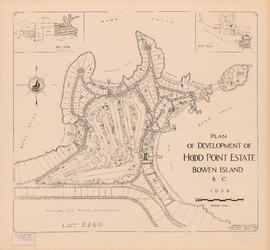
Plan of development of Hood Point Estate, Bowen Island, B.C., 1928
Part of City of Vancouver Archives technical and cartographic drawing collection
Item is a map showing division of Lot 823 on Bowen Island into smaller parcels of land and the proposed construction of a golf course. Two key plans show the location of Lot 823 in relation to the rest of Bowen Island and the position of Bowen Island in relation to Vancouver.

Plan of district lots 264, 265, 266 and 552, North Vancouver, British Columbia
Part of City of Vancouver Archives technical and cartographic drawing collection
Item is a map showing lot numbers and lot boundaries in the area from Phillips Avenue to Bewicke Avenue and Twenty-third Street to Burrard Inlet. An index map shows the location of the primary map in relation to the rest of Greater Vancouver.

Plan of government subdivision at Point Grey, B.C.
Part of City of Vancouver Archives technical and cartographic drawing collection
Item is a sheet which has been excised from the Journal of the Town Planning Institute, December 1925 issue. The sheet consists of two street layout plans and an illustration. The street layout plans show current and proposed revised street layouts for the area of Point Grey bounded by Highbury Street, Eighth Avenue, Imperial Street, and Tenth Avenue. The illustration depicts the view north from the proposed development area.

Plan of Greater Vancouver, British Columbia
Part of City of Vancouver Archives technical and cartographic drawing collection
Item is a map of Greater Vancouver from Alma Road (Alma Street) to Boundary Road and Burrard Inlet to King Edward Avenue. Map shows district lot, block, and lot numbers, waterfront businesses, rail lines, schools, parks, beaches, and concentric circles indicating distances from a point located approximately at the intersection of Cambie and Hastings Streets.
Plan of Kitsilano Indian Reserve, No. 6 (contours)
Part of City of Vancouver Archives technical and cartographic drawing collection
Item is a topographical map used as a base for showing surveying information such as lot numbers, boundaries, contours, bearings, pipelines, bridge and rail rights-of-way and other landmarks on the Kitsilano Indian Reserve. The map was likely used in planning the development of Vanier Park and/or the Vancouver Museum in the mid-late 1960s. Annotations show "most likely entrance" at McNicoll Avenue.
Vancouver (B.C.). Engineer's Office

Plan of Lot 6311, Vancouver, B.C. fronting on Kitsilano Indian Reserve No. 6
Part of City of Vancouver Archives technical and cartographic drawing collection
Item is a survey map showing lot numbers, boundaries, pipelines, bearings and landmarks on the Kitsilano Indian Reserve, as well as shorelines and the rights-of-way for the Burrard Bridge and Canadian Pacific Railway.

Plan of New Westminster City and suburban lots
Part of City of Vancouver Archives technical and cartographic drawing collection
Map shows land subdivisions and streets of New Westminster.

Part of City of Vancouver Archives technical and cartographic drawing collection
Item is a map depicting the "original plan" for District Lot 540, including the area bounded by Trafalgar Street to English bay to Campbell Street to 16th Avenue. Block numbers and the location of public parks are noted.
Vancouver (B.C.). Engineer's Office

Plan of part of subdivision of district lot 540. South Vancouver
Part of City of Vancouver Archives technical and cartographic drawing collection
Item is a map showing provincially-owned properties for sale in District Lot 540, South Vancouver, B.C.

Plan of part of sub-division of district lot 540, South Vancouver, provincial government property
Part of City of Vancouver Archives technical and cartographic drawing collection
Item is a map showing district lot, block, and lot numbers of properties for sale in the area bounded by Blanca Street, Campbell Street (Alma Street), English Bay, and 16th Avenue. Sold or reserved properties are marked in red.
Plan of Point Grey municipality
Part of City of Vancouver Archives technical and cartographic drawing collection
Item is a map showing district lot boundaries and land subdivision for the municipality of Point Grey. Electric lines and proposed electric lines are also shown.
Plan of Point Grey Municipality
Part of City of Vancouver Archives technical and cartographic drawing collection
Item is a map showing lot numbers, street names and boundaries of the municipality of Point Grey. The map also shows part of the city of Vancouver (from False Creek in the north to 16th Avenue in the south and from Ontario Street in the east to Alma in the west).
![Plan of Point Grey Municipality [ward boundaries]](/uploads/r/null/a/c/a/aca691b3d6e49d092070fc230a88f5ca7bd346fc8c5894892d7cdc5a79b535ee/9a14b192-1858-43aa-ab28-d0b03a2304eb-MAP360_142.jpg)
Plan of Point Grey Municipality [ward boundaries]
Part of City of Vancouver Archives technical and cartographic drawing collection
Item is a copy of a commercially published map of Point Grey which has been used as a base map to depict existing and proposed new ward boundaries for Point Grey municipality.
Part of City of Vancouver Archives technical and cartographic drawing collection
Item is a survey map of the Kitsilano Indian Reserve located on Kitsilano Point (now Vanier Park). The map shows lot numbers, bearings, boundaries and landmarks.
Hermon and Hermon
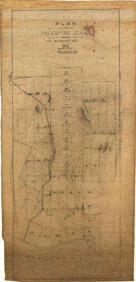
Plan of pre-emption claims, group 1, New Westminster District B.C., 1887-1888
Part of Major Matthews collection
Item is a map depicting pre-emption claims in Group 1, New Westminster District, a section of land extending north from Burrard Inlet and including Capilano Creek. The majority of claims are numbered and/or include the owner's last name. In addition to creeks, the map also shows the location of a waterworks dam, mountains, and high hills. Pencil annotations indicate the location of "Trythall's Clearing."

Plan of Provincial Government property being a portion of Townsite of Vancouver
Part of City of Vancouver Archives technical and cartographic drawing collection

Part of City of Vancouver Archives technical and cartographic drawing collection
Item is a map showing lot numbers, lot boundaries, major streets and property sold or reserved in the area bounded by Campbell Street (Alma Street), present-day Trafalgar Street (unnamed on map), English Bay, and 16th Avenue.

Part of City of Vancouver Archives technical and cartographic drawing collection
Item is a map showing lot numbers, lot boundaries and property sold or reserved northwest of Capilano Creek along the north shore of Burrard Inlet. The map does not include street names.
Part of City of Vancouver Archives technical and cartographic drawing collection
Item is an advertisement for real estate in the area bounded by Campbell Street (Alma Street), Richards Street (Balaclava Street), English Bay, and 15th Avenue, with a map of properties on one side and textual advertisements on the other.
![Plan of re-subdivision of lots 3 to 14, subn [subdivision] 2 of bk [block] 3. D.L. 391 & 392](/uploads/r/null/4/a/4a0ea6aa076433c7bcad0c847f7acb3bb1046f7abf2801c48b97d9ca58f49a73/9bd508e4-c85e-4090-b266-27571c5d4dbc-MAP754_142.jpg)
Plan of re-subdivision of lots 3 to 14, subn [subdivision] 2 of bk [block] 3. D.L. 391 & 392
Part of City of Vancouver Archives technical and cartographic drawing collection
Map shows the subdivision of lots in the block bordered by 31st Avenue East, 32nd Avenue East, St. Catherines Street and Windsor Street, at that time in the District of South Vancouver. Map is certified by the surveyor Arthur H. Holland, British Columbia Land Surveyor, and W.A. Pound, Reeve of the District of South Vancouver. It is unclear as to whether the map was commissioned by the Corporation of the District of South Vancouver.

Plan of subdivision of D in lot 183 and subdivision of J in lot 182, City of Vancouver
Part of City of Vancouver Archives technical and cartographic drawing collection
Item is a subdivision map showing block and lot numbers of subdivisions D and J in lots 183 and 182 respectively. These areas are situated roughly between Burrard Inlet in the north and First Avenue in the south and between Victoria Drive in the east and Clark in the west.
Garden, Hermon and Burwell, Provincial Land Surveyors