- AM54-S4-1-A-10-: A-8-30.1
- Item
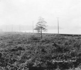
- [ca. 1913]
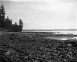
Part of Major Matthews collection
Photograph shows the area surrounding Kitsilano Beach before clearing.
200 results directly related Exclude narrower terms
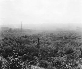
Part of Major Matthews collection
Photograph shows the area surrounding Kitsilano Beach before clearing.
Part of Major Matthews collection
Photograph shows the area surrounding Kitsilano Beach before clearing.
![[Kitsilano] Ice Rink [at 2495 West 12th Avenue]](/uploads/r/null/e/b/eb721478621e4bda9a57c84a63bed97f2584c3d59a11c99b4a350144e51252bd/dc26c67f-7ca8-4fe5-807c-7e3c8c3c65dc-A58967_142.jpg)
[Kitsilano] Ice Rink [at 2495 West 12th Avenue]
Part of City of Vancouver fonds
Photograph also shows Connaught Park, the Greater Vancouver Regl, Sewage and Drainage and Water Distict (2294 West 10th Avenue), and apartment buildings 2285 West 10th Avenue (Patna Apartments) and 2586 Vine Street
![[Kitsilano Indian Reserve, east of the Burrard Street Bridge]](/uploads/r/null/c/4/c44748477aa6ee98ce23e590bd306dc0b428eab790942a02495dbaa37e112845/fdb2aa2e-4efc-41c2-9a15-90b3993c2b9d-A09357_142.jpg)
[Kitsilano Indian Reserve, east of the Burrard Street Bridge]
Part of Major Matthews collection
Photograph shows Burrard Street Bridge, Granville Island, B.C. Electric Railway bridge across False Creek and area of reserve land, formerly an Indian garden.
![Kits[ilano] Neighbourhood House at 2305 W[est] 7th Avenue](/uploads/r/null/0/f/0f35c783f5567c016b4ed290503d9427d12f892313536d11c38e627a5301d0fb/72988507-4176-4f0a-b288-c521349168ca-A58970_142.jpg)
Kits[ilano] Neighbourhood House at 2305 W[est] 7th Avenue
Part of City of Vancouver fonds
![[Kitsilano Secondary School at 2550 West 10th Avenue]](/uploads/r/null/d/9/d948ed1b439eeea7151c09ff01708341f7f3bb8e611fe5a482b710adfb176524/994d8698-c7b5-4606-b8bb-bf8fe56e95d9-A58969_142.jpg)
[Kitsilano Secondary School at 2550 West 10th Avenue]
Part of City of Vancouver fonds
![[Mrs. Quiney carrying firewood into house at 1820 Waterloo Street]](/uploads/r/null/a/b/abb88615d3fb373655c719531006f0a580d76f53bb1291b2692fb230096f91ee/a01296b7-7583-409f-a591-618618134213-A20379_142.jpg)
[Mrs. Quiney carrying firewood into house at 1820 Waterloo Street]
Part of James Luke Quiney fonds
![Naam Natural Foods Restaurant [at 2722 West 4th Avenue]](/uploads/r/null/c/4/c476b0e0b9884812dcfac5869fafdc9d5e86e275b6929c51fcd44c1f5824c215/a903a543-41ad-463c-a54d-aa5f018756f0-A58975_142.jpg)
Naam Natural Foods Restaurant [at 2722 West 4th Avenue]
Part of City of Vancouver fonds
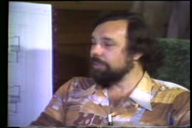
Neighbourhood Improvement Program (part four) other projects large & small
Part of Eleanore Jane Rittenhouse fonds
Item is part four of a Channel 10 documentaryabout the Neighbourhood Improvement Program (NIP) and how its funds are used to make improvements in the Kitsilano community. Jane Rittenhouse introduces topics including the N.I.P. Community Centre Project Com

Neighbourhood Improvement Program (part one)
Part of Eleanore Jane Rittenhouse fonds
Item is part one of a Channel 10 documentary about the Neighbourhood Improvement Program (NIP) and how its funds are used to make improvements in the Kitsilano community. The program includes background information on NIP, its organization, functions, ass

Neighbourhood Improvement Program (part three) caring about children
Part of Eleanore Jane Rittenhouse fonds
Item is part three of a Channel 10 documentary about the Neighbourhood Improvement Program (NIP) and how its funds are used to make improvements in the Kitsilano community. Jane Rittenhouse describes the relationships between the bodies involved in the N.
![Neighbourhood Improvement Program (part two [A]) schools and people](/uploads/r/null/5/7/2/572449ba3f0d02db9456a451607b9058c6d6b13d8a074b9ab83c3a8257b6f53b/f732f209-5643-4d15-9e65-eb4569431ffa-LEG181_142.jpg)
Neighbourhood Improvement Program (part two [A]) schools and people
Part of Eleanore Jane Rittenhouse fonds
Item is part two (of a Channel 10 documentary about the Neighbourhood Improvement Program (NIP) and how its funds are used to make improvements in the Kitsilano community. In this program, Jane Rittenhouse briefly recaps the source of N.I.P. funds and the
![Neighbourhood Improvement Program (part two [B]) schools and people](/uploads/r/null/9/0/c/90c5b4ba2c3dbe8efcd2eb98302db72e91b43bbb52eafd6a8e3b82aea195633f/e6020fdb-9f29-4bed-a890-6c74551555e2-LEG181_142.jpg)
Neighbourhood Improvement Program (part two [B]) schools and people
Part of Eleanore Jane Rittenhouse fonds
Item is part two of a Channel 10 documentary about the Neighbourhood Improvement Program (NIP) and how its funds are used to make improvements in the Kitsilano community. Jane Rittenhouse discusses how N.I.P. funds were used to build a playground at Henr
![[Ogg home at 3425 2nd Ave. W.]](/uploads/r/null/7/1/718bd4eab11fa71e30bc70feaca322bcdda7ab119aa7117b8c7d1cefb90ee408/9e7479fc-3a80-4b27-911a-924b71d2a608-A20362_142.jpg)
[Ogg home at 3425 2nd Ave. W.]
Part of James Luke Quiney fonds
![[Ogg home at 3425 2nd Ave. W.]](/uploads/r/null/0/8/08071bd02193753afe3b35a77ce612d1e5115593614616683b4acd5f1e5b269d/33c1ac05-e502-48ec-845d-29332dc1c432-A20364_142.jpg)
[Ogg home at 3425 2nd Ave. W.]
Part of James Luke Quiney fonds
![[Park in Kitsilano]](/uploads/r/null/5/0/50865667f2f73aaa6f5a1276ba9d89dff63332daa130139ff3cf4a79afb9dec7/438ccbe4-ec5f-4389-b02a-3538e004f960-A58937_142.jpg)
Part of City of Vancouver fonds
![[Park in Kitsilano]](/uploads/r/null/8/c/8c788190e799e3dce0c8fba93d7be61805bef5fb9721a4981138f4f1efd0f381/7a808d97-5e29-42e3-b621-1c23c92a66d1-A58939_142.jpg)
Part of City of Vancouver fonds
Photograph also shows Kitsilano Beach
![[Park in Kitsilano]](/uploads/r/null/4/3/431c20410056dfd271b6afb44f676c394e28cc057432e4878ea260b313f46c03/5e5665ff-d0bc-467c-ae60-c9f5a1fbd4de-A58941_142.jpg)
Part of City of Vancouver fonds
![[Park in Kitsilano]](/uploads/r/null/0/f/0f786d95281cee62f10de2bc2ae3b535ab86ad22c0f0a04d5983c707cea7300c/98c50fdd-a92a-461d-a048-ef1db4db987d-A58938_142.jpg)
Part of City of Vancouver fonds
![Paving finish on invert for 5'6" interceptor in [sewage] tunnel at 1st avenue near Vine Street](/uploads/r/null/f/3/f3e44df5584efe0cbaaa2f1dc3c7fecc40289a78b7d00ab17da8ed1baad53bef/2862f8db-a8d7-4aa9-9b33-73956f89ba99-CVA275-7_142.jpg)
Paving finish on invert for 5'6" interceptor in [sewage] tunnel at 1st avenue near Vine Street
![[People on Kitsilano Indian Reserve beach at foot of Chestnut Street]](/uploads/r/null/0/c/0cae8926d5605ab2e8eb98eb30accdddf895dc1d27ebb335795877b71a09cecf/1e98cc72-36c7-413d-9d72-d2e14cddc760-A09349_142.jpg)
[People on Kitsilano Indian Reserve beach at foot of Chestnut Street]
Part of Major Matthews collection
J.S. Matthews' notes with print or negative in Archives.
![[People on Kitsilano Indian Reserve beach by Burrard Street Bridge]](/uploads/r/null/c/4/c4467e9e451c58a5ef323a5f2c44ac645b658bb022ab9ed14b1414775acc6cc8/43715b1e-a5af-4c21-9023-2f09ce98fcb3-A09353_142.jpg)
[People on Kitsilano Indian Reserve beach by Burrard Street Bridge]
Part of Major Matthews collection
![[People on Kitsilano Indian Reserve beach by Burrard Street Bridge]](/uploads/r/null/e/8/e8a57f8c7bfdb281d09529f8c15ef51fb2871ed845dae57b13bbab005239b9da/da331da4-ac2d-4cec-9a19-46fef429835e-A09354_142.jpg)
[People on Kitsilano Indian Reserve beach by Burrard Street Bridge]
Part of Major Matthews collection
![[People on Kitsilano Indian Reserve beach near Cedar Street]](/uploads/r/null/5/e/5eb2c7d695531ec13a8ef96d3ff63ac3c8fe0e008ac254191b9832bc7b7c4fcf/6acd542f-9ef1-4da0-b2ef-552a7c0fde54-A09351_142.jpg)
[People on Kitsilano Indian Reserve beach near Cedar Street]
Part of Major Matthews collection
J.S. Matthews' notes with print or negative in Archives.
![[People on Kitsilano Indian Reserve beach near Pine Street]](/uploads/r/null/4/a/4a8077e43e9aeb06486bacab47b8aab0c72fa5036935d1c2b8dc0b3e3979cf89/5ed5019c-c339-4e7c-8636-5e5519a592b1-A09352_142.jpg)
[People on Kitsilano Indian Reserve beach near Pine Street]
Part of Major Matthews collection
J.S. Matthews' notes with print or negative in Archives.
![[People on Kitsilano Indian Reserve beach, east of Chestnut Street]](/uploads/r/null/d/3/d381459a158ec366f7de1eadb71aff5da63483ccffdf09d953621ca00bc0c737/1c84e499-59f3-4df7-b874-0fd7183df41a-A09350_142.jpg)
[People on Kitsilano Indian Reserve beach, east of Chestnut Street]
Part of Major Matthews collection
J.S. Matthews' notes with print or negative in Archives.
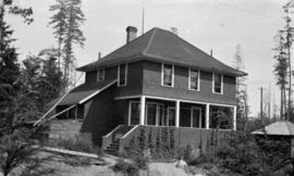
![[Pioneer home of James Quiney, northeast corner of Dunbar Road and Fourth Avenue]](/uploads/r/null/7/7/77475ed1e239ee5cf6923c93beefcb03025cfab6e2f7c7ad0e29465efcfe9cdb/cfd445f7-e6c3-45f9-bdf1-b38148450a6d-A20315_142.jpg)
[Pioneer home of James Quiney, northeast corner of Dunbar Road and Fourth Avenue]
Part of James Luke Quiney fonds
Pioneer home of Mr. and Mrs. J.L. Quiney, northeast corner of Dunbar Road and Fourth Avenue.
Part of James Luke Quiney fonds
![Playmates [Theresa Quiney with bear cub and dog]](/uploads/r/null/9/2/9250154b3803b95d0617f9cde2eacf8f730ff47b78735e1e18e22329d7d89d5d/a42bfd5a-f71d-48d5-ba08-5b24772ce161-A20335_142.jpg)
Playmates [Theresa Quiney with bear cub and dog]
Part of James Luke Quiney fonds
![[Point Grey Road Waterfront Park]](/uploads/r/null/c/9/c9faa13bb2b8c2f0c429b90d90f959707687ba72f7bd3c75e051e307f14f8b61/85333e38-c299-4184-ad33-fece41a848f0-A58944_142.jpg)
[Point Grey Road Waterfront Park]
Part of City of Vancouver fonds
Photograph also shows the North Shore and Stanley Park
![[Preparing double track for streetcar line on 4th Avenue near Waterloo Street]](/uploads/r/null/b/7/b73df01e2e3204db5e7626adeab76bd56091c55d26186854a32665cdf13f8317/cee66608-9bf3-4ce1-bcee-937d981db9de-A20385_142.jpg)
[Preparing double track for streetcar line on 4th Avenue near Waterloo Street]
Part of James Luke Quiney fonds
![[Quiney house at 1820 Waterloo Street]](/uploads/r/null/4/a/4a299de7325657533dd1f6cba7aefcdfb943e3488a1c2ecf6159e415c1e62656/5486774d-c0c4-4040-a5ee-5f0f358091ca-A20353_142.jpg)
[Quiney house at 1820 Waterloo Street]
Part of James Luke Quiney fonds
![RCAF Base [No. 2 Equipment Depot in Kitsilano]](/uploads/r/null/5/f/5ffae0cf94e2d913d0fec944aaffddf8db7f954af140054ac9eb9b44a4a6b715/77297584-bc04-48c2-869d-d7f3713fd429-A59297_142.jpg)
RCAF Base [No. 2 Equipment Depot in Kitsilano]
Part of City of Vancouver fonds
Photograph also shows False Creek, English Bay and the West End

Remains of a logging trail, Kitsilano
Part of James Luke Quiney fonds

Residence of J.Z. Hall, "Killarney," at 2890 Point Grey Road
Part of James Luke Quiney fonds
![[Residence of R.D. Rorison at 3148 Point Grey Road]](/uploads/r/null/d/8/d88f3a736f721e8419d6f34dad7cdbef056ada01dc367669cbab972c5df303c3/f401f847-4c44-479a-8d3a-c5a0a23115e3-A20395_142.jpg)
[Residence of R.D. Rorison at 3148 Point Grey Road]
Part of James Luke Quiney fonds
![[Residence of R.D. Rorison at 3148 Point Grey Road]](/uploads/r/null/9/4/94714254f5f5cce581cf248c5ddd3cc1506aae53780cf0841aaf0af3a9318973/c074d5b6-2cbc-488f-95c1-24946297b0ea-A20394_142.jpg)
[Residence of R.D. Rorison at 3148 Point Grey Road]
Part of James Luke Quiney fonds
![Seaforth Arm[ory at 1650 Burrard Street]](/uploads/r/null/c/1/c11992b03dd67aa5260ceeb910f67ede0942edf185129788bb1a8041ba872869/c1e154dd-60b3-4a17-9df0-5d22bb57d68c-A58972_142.jpg)
Seaforth Arm[ory at 1650 Burrard Street]
Part of City of Vancouver fonds
![[Shacks on shore of Kitsilano Indian Reserve]](/uploads/r/null/b/0/b01db3724b619dbd3003a0951790d34deeb68459f7b14a1bc000c1246e312b77/00bfca51-721d-45aa-b304-aaf26dd21521-A09356_142.jpg)
[Shacks on shore of Kitsilano Indian Reserve]
Part of Major Matthews collection
J.S. Matthews' notes with print or negative in Archives.
![[Shops along] 4th [Avenue] and MacDonald [Street]](/uploads/r/null/e/4/e4e2c71e9c3f7a413d4d21c9aa1c80f8f1caaed5aca9d43d28a567fb1f2ee75a/f83242b1-e966-40fd-84be-a71267749cb7-A58973_142.jpg)
[Shops along] 4th [Avenue] and MacDonald [Street]
Part of City of Vancouver fonds
![[Shops along West] 4th Ave[nue] and Cypress [Street]](/uploads/r/null/b/4/b40dc85512f5f69b085b35dc4bb64e04c82b5feed0c5205c111b959b8e435314/578e715a-2631-43fd-88f2-c080a9ab705e-A58974_142.jpg)
[Shops along West] 4th Ave[nue] and Cypress [Street]
Part of City of Vancouver fonds
Photograph also shows buildings and businesses including the Cypress Confectionery (1903 West 4th Avenue)
![[Site of Seaforth Armoury on Kitsilano Indian Reserve]](/uploads/r/null/5/3/5379cdb330c643b443916ea2354d52ada6ce1234f4480dddd066837bcc69868b/8382c8f3-f5f4-4fab-a277-ba05af41db42-A09359_142.jpg)
[Site of Seaforth Armoury on Kitsilano Indian Reserve]
Part of Major Matthews collection
Photograph shows location of armoury and houses, schools and buildings along Cornwall Street and Cypress Street. J.S. Matthews' notes with print or negative in Archives.
![[Site of Seaforth Armoury on Kitsilano Indian Reserve]](/uploads/r/null/9/d/9d85bd2d98b273b6518780e87fb4191e92eafd4e69b46ece216d0246f8666c55/621ad8e5-10b4-4a4d-a8cc-2a6e9e15f1e5-A09360_142.jpg)
[Site of Seaforth Armoury on Kitsilano Indian Reserve]
Part of Major Matthews collection
Photograph shows location of armoury and houses, schools, and buildings along Cornwall and Cypress Streets.
![[Snow scene at Waterloo Street at 2nd Ave. W.]](/uploads/r/null/e/1/e17168dea32af70dd0a2314dcf9d19b25f6a7d0a2aecadc76fbc8efbfe7f6642/53fd557e-51bb-4d01-8205-1391ddfd8cf8-A20367_142.jpg)
[Snow scene at Waterloo Street at 2nd Ave. W.]
Part of James Luke Quiney fonds
Stanley Park, Second Beach, English Bay, and Kitsilano
Item is a photograph of Second Beach at Stanley Park. The photograph was taken from Second Beach looking south across the beach to English Bay with Kitsilano beyond it.
![[Stores along the 2900 block Broadway at Bayswater Street]](/uploads/r/null/2/3/235a8f1922782840a18ed5891a1f8c7597e74edcff30706ce73aa9608c289d68/77737a85-35fa-48f7-8890-a29942b7534a-A58950_142.jpg)
[Stores along the 2900 block Broadway at Bayswater Street]
Part of City of Vancouver fonds
![[Street in Kitsilano]](/uploads/r/null/9/9/995b64e959c5d0a2bd16b4ad59feda2f735201ac7a9d2440b83b0ff59c9015f7/26acbbfe-74dd-4783-b448-a76b1f679dc7-A58952_142.jpg)
Part of City of Vancouver fonds
Photograph also shows houses
![[Street in Kitsilano at McNicoll Avenue]](/uploads/r/null/9/f/9f85bec92705b4a14427398af91174ed15a8a950b1a30e108ef60e121955de34/4497797d-670e-4f70-91af-a6317147272f-A58953_142.jpg)
[Street in Kitsilano at McNicoll Avenue]
Part of City of Vancouver fonds
Photograph also shows houses
![Tatlow Court [at] 1800 Bayswater [Street]](/uploads/r/null/e/f/efc12aaab1d346e15b91642366076abf42530c2aca529853de50f58e37e54de5/7ff7f2f7-e048-44d8-a9fa-4ca394874b98-A59077_142.jpg)
Tatlow Court [at] 1800 Bayswater [Street]
Part of City of Vancouver fonds

Tatlow Park, families using park facilities with homes in the background
Item is a photograph of Tatlow Park, including children playing on the wooden bridge, women relaxing on benches, and men playing lawn bowling on the grass. The photograph was taken from the park pathway looking southwest. Houses are visible in the background, including Seagate Manor (2831 Point Grey Road) in the middle left.