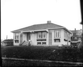
![[Henry] Hudson [Elementary] School [at 1551 Cypress Street]](/uploads/r/null/0/2/02daa6531376a535dff9bb9e4f40c98c06be0fe4912be872010e00565aa25e6e/1763ebc4-89d0-43a3-b817-96de6051cbe0-A58958_142.jpg)
[Henry] Hudson [Elementary] School [at 1551 Cypress Street]
- COV-S511---: CVA 780-178
- Item
- Nov. [19]77
Part of City of Vancouver fonds
200 results directly related Exclude narrower terms
[Henry] Hudson [Elementary] School [at 1551 Cypress Street]
Part of City of Vancouver fonds
![[Home of George Ogg, 3425 2nd Ave. W]](/uploads/r/null/b/b/bbd40f3c9bae619124b0308b34957f86b77cf73954a25dea2117a422ea92a070/27e074a6-e97a-45ca-b3ae-facdccdef111-A20347_142.jpg)
[Home of George Ogg, 3425 2nd Ave. W]
Part of James Luke Quiney fonds
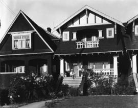
![[House and apartment building in Kitsilano]](/uploads/r/null/d/8/c/d8c500b307b5843514b956ebff2aea2d01dee6cf53aad693005afa24bad82cb9/49c0fa67-4e22-4316-9e46-f13f440aa067-CVA808-3_142.jpg)
[House and apartment building in Kitsilano]
Part of City of Vancouver fonds
House at 1846 15th Avenue West, built under soldiers' housing scheme
Part of Stuart Thomson fonds
![[House at] 3152 Point Grey [Road]](/uploads/r/null/2/4/2432279ea5b80177ea34d5779adbabdd2012cccde6b749be4ed47ac11af1ab7d/b355d7a5-cca9-45e2-9eb3-a82c0ea99a95-A59074_142.jpg)
[House at] 3152 Point Grey [Road]
Part of City of Vancouver fonds
![[House in Kitsilano]](/uploads/r/null/4/c/4c8fe7223209756140c114e5f1be05ce632f89c7896df0c91fbece8756f2aa9f/2a1db002-789d-4824-9c92-f01c8f3d138d-A58934_142.jpg)
Part of City of Vancouver fonds
![[House in Kitsilano]](/uploads/r/null/2/c/2cca716acb48e681bc19cb724a08342b541ece9647f7ce81b57b9e2f4c6dbdfa/a0f5613d-51e7-433b-b021-22353a21d77b-A58932_142.jpg)
Part of City of Vancouver fonds
Part of Stuart Thomson fonds
![[House near 2nd Ave. W. and Waterloo Street]](/uploads/r/null/0/3/03f2c82a48cd0281f50995cf9a57a253d5d5a02df794bda0f86abb4fe255ae74/92102702-2d3c-4c61-ac6f-defd7dc69194-A20390_142.jpg)
[House near 2nd Ave. W. and Waterloo Street]
Part of James Luke Quiney fonds
Photograph shows property damage from a fallen tree.
![[House near 2nd Ave. W. and Waterloo Street]](/uploads/r/null/9/6/964872c33ca58ef106ed65469a72164599f3331283101fa5414a2aaef5c2334a/dd23b700-8211-4984-b297-29395cde478f-A20388_142.jpg)
[House near 2nd Ave. W. and Waterloo Street]
Part of James Luke Quiney fonds
Photograph shows property damage from a fallen tree.
![[House near 2nd Ave. W. and Waterloo Street]](/uploads/r/null/7/8/78d5649f0ab192b8abafb19930dd6fff249ba969737774bf94ed6bce626f460d/72e340b0-7b7f-4d13-8e57-b31fbef12963-A20389_142.jpg)
[House near 2nd Ave. W. and Waterloo Street]
Part of James Luke Quiney fonds
Photograph shows property damage from a fallen tree.
![[House on] Trutch Street close to 3rd Ave. W.](/uploads/r/null/1/4/14e7b76b45b25d39cd492d617b41bc0096feaa91187581b83824b9cdad668fb1/f4e24828-e731-494c-9f8e-44a6516c3112-A20346_142.jpg)
[House on] Trutch Street close to 3rd Ave. W.
Part of James Luke Quiney fonds
![[Houses] 2722-2758 W[est] 7th [Avenue]](/uploads/r/null/0/e/0eefa3e5dbec74be74a4b028fb193180501489a3f82cea2d21f5db4fedf9b618/19a20b17-3031-4eca-a032-b372c3a6ad4a-A58982_142.jpg)
[Houses] 2722-2758 W[est] 7th [Avenue]
Part of City of Vancouver fonds
![[Houses] 2722-58 W[est] 7th [Avenue]](/uploads/r/null/6/2/622c427614eba14f61bfdcffae8140690d9056bd04308497b1b6948e83bc854f/31154b6a-e017-4e45-90b7-7a7b04ea69e5-A58930_142.jpg)
[Houses] 2722-58 W[est] 7th [Avenue]
Part of City of Vancouver fonds
![[Houses] 2814 W[est] 7th [Avenue and] 2820 W[est] 7th [Avenue]](/uploads/r/null/d/1/d10423b5412ffd24d95d9b4d1acb554f0113c6fc656c73a67286ec71dbf67aa9/7e960dd1-5af6-41d4-9e18-9351ea458ebe-A58979_142.jpg)
[Houses] 2814 W[est] 7th [Avenue and] 2820 W[est] 7th [Avenue]
Part of City of Vancouver fonds
![[Houses] 2819-2805 W[est] 7th [Avenue]](/uploads/r/null/1/e/1e2df484f39f373211818223a9c1c7b7948b64e8e896697b5a59a8d44cb99103/21b73b33-f348-4d43-b1d1-94f902143292-A58981_142.jpg)
[Houses] 2819-2805 W[est] 7th [Avenue]
Part of City of Vancouver fonds
![[Houses in Kitsilano]](/uploads/r/null/6/8/68f06ce6dde97dc34d6de508380ae6b1aa75c28f43f3ea4b0f58e46e584a4ef3/f61f1fae-b54c-4ae2-8b7f-18e22557f2be-A58936_142.jpg)
Part of City of Vancouver fonds
Photograph also shows a railway crossing
![[Houses in Kitsilano]](/uploads/r/null/1/4/14531163dbf358f0f6ae37f29a12e6fc125f75cfcfa21f51a255ca87e477df11/240e282b-04fe-4f58-b0d2-6224bece0b9e-A58929_142.jpg)
Part of City of Vancouver fonds
![[Houses in Kitsilano]](/uploads/r/null/a/6/a6eb98108e3ef8cf28e473f7f1e790452b9e1d4b5e50554dadbde27b8f9741ef/3959becb-dbff-4706-894a-d06e2572cafa-A58935_142.jpg)
Part of City of Vancouver fonds
![[Houses in Kitsilano]](/uploads/r/null/7/e/0/7e04217e7957c0cf375ee29846bc04c16dc03d0edc9159cbe9a098035b3bc611/5737f27b-73a6-44a7-95c3-6f0befffbbe7-CVA808-4_142.jpg)
Part of City of Vancouver fonds
![[Houses in Kitsilano]](/uploads/r/null/7/6/76a96f445b329049d2888e0c83eb0953cff44b145f88befbf95d00ff5f5bfc8c/2327eb87-d5b5-4094-9ae9-a032d33fe9f8-A58927_142.jpg)
Part of City of Vancouver fonds
![[Houses in Kitsilano]](/uploads/r/null/5/5/a/55ae24b66c9ac313c74635184be9b941fe7fcc4e380ac339b43e37f6bab74b24/507164fd-a66d-41a4-924d-9f6f1160f8d1-CVA808-1_142.jpg)
Part of City of Vancouver fonds
![[Houses in Kitsilano]](/uploads/r/null/3/4/4/344d15796f2c3500294073c90fa782c0f0f8a63a01053fb3c2784628527b336b/53f61997-50b3-44f2-9970-73647972523e-CVA808-5_142.jpg)
Part of City of Vancouver fonds
![[Houses in Kitsilano]](/uploads/r/null/a/3/f/a3f2366e0cb3221dc412ce3a991413c10590721500a7c5ead1b32b4de3ee3e8e/ffe1bef9-efb5-41aa-a862-59a8dd8597c8-CVA808-6_142.jpg)
Part of City of Vancouver fonds
![[Houses on] Point Grey Road, near Waterloo Street](/uploads/r/null/9/1/91c102569f0ecb056d91b4a442b3d649657660f3774f7f717b85f6d27f107f2e/6efeb3f2-0169-475a-86cf-b2aaa0ec3e78-A20401_142.jpg)
[Houses on] Point Grey Road, near Waterloo Street
Part of James Luke Quiney fonds
![[Hudson parked on street in front of 3628 West 3rd Avenue]](/uploads/r/null/5/d/5dcb26a6db250f1907e041d1693f321d8f14d0dd80d92f87239859c4d56cfd49/c355b851-342b-4fd1-833c-502ca56da21e-A59794_142.jpg)
[Hudson parked on street in front of 3628 West 3rd Avenue]
Photograph shows houses at 3637 West 3rd Avenue and 3629 West 3rd Avenue.
![[James L. Quiney with bear cub near 1820 Waterloo Street]](/uploads/r/null/c/5/c5b5001e2752b0174f4273dba5a9d99c86f9e9129e5e5ad95abac0914b1467fe/ebf5b920-eb06-4e74-925e-e2c63e7a03bc-A20377_142.jpg)
[James L. Quiney with bear cub near 1820 Waterloo Street]
Part of James Luke Quiney fonds
![[James L. Quiney's home and real estate office at 1820 Waterloo Street]](/uploads/r/null/9/b/9b07af417aed7087239dff703990d74fb5e58e99788cede3715efa416ad87bf0/2983643a-d474-467d-983a-c30d0a559e93-A20366_142.jpg)
[James L. Quiney's home and real estate office at 1820 Waterloo Street]
Part of James Luke Quiney fonds
![[James Quiney and two bear cubs at 1820 Waterloo Street]](/uploads/r/null/a/a/aaa5ef8620e5537ebac6d7099e5827f11d73fed78714be77369847aa61ac7d67/1b33cea4-2d0b-4a89-8a42-a4eeead2fee0-A20334_142.jpg)
[James Quiney and two bear cubs at 1820 Waterloo Street]
Part of James Luke Quiney fonds
![[James Quiney in front of his real estate office at 1820 Waterloo Street]](/uploads/r/null/0/1/011ac70b711c9a9749000639e4ad3a29dcd924c9f55b465144a9475bf5141085/3279078d-60c5-4c35-b7ee-705f0878c927-A20365_142.jpg)
[James Quiney in front of his real estate office at 1820 Waterloo Street]
Part of James Luke Quiney fonds
![[James Quiney Real Estate office at 1820 Waterloo Street]](/uploads/r/null/f/7/f7f5eea3fb93bc37cfdbd62dc5ae579b9ce482a0c307e0e656dff58bcbbe9a0c/3b6d52f1-c763-426b-a225-08778a229afe-A20355_142.jpg)
[James Quiney Real Estate office at 1820 Waterloo Street]
Part of James Luke Quiney fonds
![[James Quiney residence and Real Estate office at 1820 Waterloo Street]](/uploads/r/null/b/4/b460a645bd35c713e27a3eaf8e129fe4eb5b39b5267a512bdbdcf9a13dd0c65f/e14a3587-e828-49cf-9928-c4ba320e4e9d-A20359_142.jpg)
[James Quiney residence and Real Estate office at 1820 Waterloo Street]
Part of James Luke Quiney fonds
![[James Quiney's Real Estate Office and residence at 1820 Waterloo Street]](/uploads/r/null/e/8/e81f935bf31a4544f2d1a745e0b2fbd13641b219206fa8d3442c257a5d942c12/05135599-f146-452d-bbba-2b5c36a25eaf-A20357_142.jpg)
[James Quiney's Real Estate Office and residence at 1820 Waterloo Street]
Part of James Luke Quiney fonds
![[J.L. Quiney residence and real estate office at 1820 Waterloo Street]](/uploads/r/null/4/5/4558b21f27baaef8c91d8d641b68dfe142d4241958c4f010b605b3bb495f1a41/eb9bb5cb-5d80-43a5-8e8c-8ea13fc0c751-A20361_142.jpg)
[J.L. Quiney residence and real estate office at 1820 Waterloo Street]
Part of James Luke Quiney fonds
![[J.L. Quiney residence and real estate office at 1820 Waterloo Street]](/uploads/r/null/b/b/bb3ffddfa498edcb0e2b5bbb1eab6a9d2e2e68b175a63a149a4fb5427aefa1be/e256b15a-0174-4c63-a523-772b549ad671-A20351_142.jpg)
[J.L. Quiney residence and real estate office at 1820 Waterloo Street]
Part of James Luke Quiney fonds
![[Junction of Cornwall and Cedar at entrance to Burrard Street Bridge]](/uploads/r/null/e/d/eda6121f6fe36fded5df5fd98c6002033c3ffc5b383775e28d2a51ce36ababcd/54c6217d-132b-48cb-92ad-f9e08b5f9dd8-A09358_142.jpg)
[Junction of Cornwall and Cedar at entrance to Burrard Street Bridge]
Part of Major Matthews collection
Photograph shows site of Seaforth Armoury on Kitsilano Indian Reserve land and houses along Cornwall Street and on Kits. Point.
![[J.W. Morrison house at 1749 Waterloo Street and 2nd Ave. W.]](/uploads/r/null/5/2/52362407035cde8a5fe6ea76817939b9410e395b894d400bdaef17e433718d04/ed6bcff8-9395-4941-915d-f5348726d994-A20381_142.jpg)
[J.W. Morrison house at 1749 Waterloo Street and 2nd Ave. W.]
Part of James Luke Quiney fonds
![[Kitsilano Beach]](/uploads/r/null/7/f/7faaee3b1e95a802e761c36b711ba1954bd00c87285b8dfbe46ed1f6daa95569/435ef841-371c-41cf-a55f-4524781f2195-A58943_142.jpg)
Part of City of Vancouver fonds
Kitsilano Beach from Major Matthews' residence, V-J Day
Part of Major Matthews collection

Kitsilano Beach from Major Matthews' residence, V-J Day
Part of Major Matthews collection
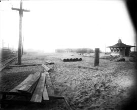
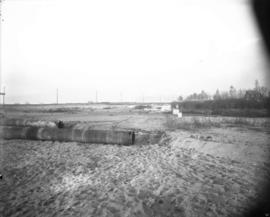
Kitsilano Beach, construction materials, bathhouse, and change stall
Item is a photograph of Kitsilano Beach, looking west towards the bathhouse. Railway tracks and utility poles are visible on the left, and lumber, piping, and unused poles are visible on the beach. There is a change stall visible on the right.

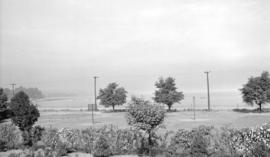
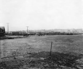
Kitsilano Beach, southern shore line from Arbutus Street
Item is a photograph of the natural rocky southern shore line of Kitsilano Beach, with Arbutus street on the far left. Men with horses are working on the beach, and buildings are visible in the background along Cornwall Street. Taken from a walkway at the northwestern corner of the beach.

Kitsilano Beach, southern shore line to Balsam Street
Item is a photograph of the natural rocky southern shore line of Kitsilano Beach, with Balsam Street on the far right. Men with horses are working on the beach, and buildings are visible in the background along Cornwall Street. Taken from a walkway at the northwestern corner of the beach.
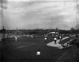
Kitsilano Beach, tennis courts
Item is a photograph of the tennis courts at Kitsilano Beach. The view is looking east across the courts at the bathhouse and beach in the background.
Kitsilano Beach, unused utility poles
Item is a photograph of Kitsilano Beach, looking northwest. Unused utility poles are visible on the beach.
![[Kitsilano] Comm[unity] Cent[re] and Ice Rink [at 2495 West 12th Avenue]](/uploads/r/null/d/9/d9d761b639f1d0ac4a01b48249a9f15db50161c1906b66a8a6f3bd78fae21c89/69059b05-f0ca-4d67-903f-216fd4844af0-A58965_142.jpg)
[Kitsilano] Comm[unity] Cent[re] and Ice Rink [at 2495 West 12th Avenue]
Part of City of Vancouver fonds
Photograph also shows Connaught Park, the Greater Vancouver Regl, Sewage and Drainage and Water District (2294 West 10th Avenue), and apartment buildings at 2285 West 10th Avenue (Patna Apartments) and 2586 Vine Street
![Kits[ilano] Comm[unity] Cent[re at 2495 West 12th Avenue]](/uploads/r/null/0/2/02bf0eaeb41557d7c992b24b8fa875759d9b7c296f06793928db279260634040/a8fc8dc3-a8f6-4914-9229-92461d24dd72-A58966_142.jpg)
Kits[ilano] Comm[unity] Cent[re at 2495 West 12th Avenue]
Part of City of Vancouver fonds
![Kits[ilano] Daycare](/uploads/r/null/3/c/3c17f7be5ba0518b0642ae21242b48abb2983ccb4fe4fc867b3bd6da4feff9b2/4b25326d-d057-459d-876d-fdd0b887b1f5-A58968_142.jpg)
Part of City of Vancouver fonds
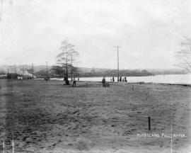
Part of Major Matthews collection
Photograph shows the area surrounding Kitsilano Beach after clearing.
Part of Major Matthews collection
Photograph shows the area surrounding Kitsilano Beach after clearing.