
- AM54-S4-1-A-6-: A-6-163
- Item
- [186-?]
Part of Major Matthews collection
688 results with digital objects Show results with digital objects
Part of Major Matthews collection
![Lytton B.C. - Frazer [Fraser] River](/uploads/r/null/1/a/1a476318c531e1a5ab3193afe22d81e9415b54f8c1a7db1e5fbc10524f9fafbe/8e4ee711-cbd1-45ea-adc6-b1cca922086b-A22920_142.jpg)
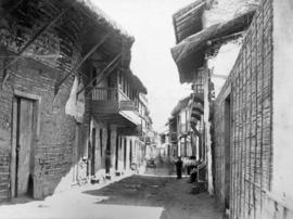
Lytton B.C. - Frazer [Fraser] River
Part of Major Matthews collection
Photograph shows the main street and businesses.
Part of Major Matthews collection
![[Horse and cart travelling along] 34th Avenue [now 33rd Ave.] before paving](/uploads/r/null/1/b/1bea09e65d46b4109283423d33373961bada71fdd08bf41e25c639f1387eb3a6/ec202a7a-9fdb-4901-9fe9-d5885081dc3d-A19285_142.jpg)
[Horse and cart travelling along] 34th Avenue [now 33rd Ave.] before paving
Part of Major Matthews collection
![[Houses in South Vancouver]](/uploads/r/null/9/6/96beb114cdd36eb0925112d2fd5239b964d9de446cf79bd3c538c89ef082f0b8/090fc4d6-bd26-46bc-835f-1b2282ac15df-A19300_142.jpg)
Part of Major Matthews collection
Photograph shows houses on a residential street with wooden sidewalks and an unpaved road.
![[Street car outside the Winram Block, 17th and Main St.]](/uploads/r/null/e/1/e14e644a588b3f93678f4c964d20100150b12ddfe3bf74e33850981e29b76c8b/a52e4081-8f51-4943-a4c5-3fadd9085e6b-A19271_142.jpg)
[Street car outside the Winram Block, 17th and Main St.]
Part of Major Matthews collection
![[View of 33rd Avenue showing road work in progress]](/uploads/r/null/b/3/b3d6aa7eb8fb0bf11bef829f4930510c09435ec0ead8048f44cfbf1708600abf/b1595b8e-b135-4c1d-a4e8-8737f2850cd0-A19297_142.jpg)
[View of 33rd Avenue showing road work in progress]
Part of Major Matthews collection
![[View of a dirt road, possibly 33rd Avenue, with street car tracks along one side]](/uploads/r/null/c/6/c64e9d504cc9b533bf0c5d0399db85273e1137fd7e3945aa2e84aa82a215b053/db19eae9-2562-40d9-9249-b36cc0c36f0b-A19282_142.jpg)
[View of a dirt road, possibly 33rd Avenue, with street car tracks along one side]
Part of Major Matthews collection
![[View of the] Main St. bog [between 33rd Avenue and 41st Avenue]](/uploads/r/null/7/f/7fb80b09ebfd64e91e42bdfb033c7901f4187e4e47fb8a675f55ecce664255be/0d0df890-2794-44d1-b878-b21f154e60b1-A19256_142.jpg)
[View of the] Main St. bog [between 33rd Avenue and 41st Avenue]
Part of Major Matthews collection
![[View of] 56th Avenue](/uploads/r/null/5/e/5e6e63808539d76e2bb1611fb7f58e19d6ff2f5c79c8c0fb9a41ae096f1041e3/c876d1dc-483f-4911-be0a-4ea8219a7537-A19232_142.jpg)
Part of Major Matthews collection

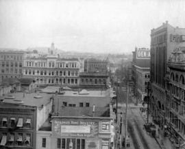
One of Vancouver's business streets
Part of Major Matthews collection
Photograph shows Hastings Street looking west from Cambie including the Flack Block and Dominion Trust building.
![4th [Avenue] and Larch [Street] northeast](/uploads/r/null/c/9/c93c44f1bdb85311e4581ec681d14862ccc914d0f7bf1ca734ebf177c7889149/85903af6-7d8c-4308-8c11-4e39c6ac4dbc-A20284_142.jpg)
4th [Avenue] and Larch [Street] northeast
Part of Major Matthews collection
Photograph shows a Ruddy-Duker Ltd. billboard advertising Beach "Lady Betty" Gas Ranges and a street car in the background
![[Lighted Ruddy-Duker Ltd. billboard advertising Modernize Electric Ranges]](/uploads/r/null/4/4/44e8778ff3f8f59bf954c36b850c8d06a53cfddc4073e75fd7c716539b723925/149b3768-eec6-4c42-ad47-00605f8481eb-A20288_142.jpg)
[Lighted Ruddy-Duker Ltd. billboard advertising Modernize Electric Ranges]
Part of Major Matthews collection

Part of Major Matthews collection
![Cambie [Street] and 2nd [Avenue] facing northwest](/uploads/r/null/a/4/a487590ab1aaa07e3403d87c275927901a8fb986725e95733e3b52f01c8a4df0/7b4ac595-0677-4988-8384-fd601251c684-A20278_142.jpg)
Cambie [Street] and 2nd [Avenue] facing northwest
Part of Major Matthews collection
Photograph shows an empty Ruddy-Duker Ltd. billboard frame looking south from the Connaught (Cambie) Bridge
![Granville [Street] and 11th [Avenue] southeast](/uploads/r/null/2/f/2f1584d55787d78f0a0b1294b2b86a03fad9b109de49c06aa64817ec8cedd059/1298e27a-4c9e-4fd5-855b-561f784664ca-A20272_142.jpg)
Granville [Street] and 11th [Avenue] southeast
Part of Major Matthews collection
Photograph shows the east side of the 2600 Block of Granville Street looking south including The Book Shop, Mayfair, Granville Music Shop and other businesses and a Harry Duker Ltd. billboard advertising Moffats Ranges
![Hastings [Street] and Campbell [Avenue] northwest](/uploads/r/null/2/6/26120c29ad2356b59d4ca6a6422a153784c8ad4191068352181fa682d1c7019e/190657a5-6e78-4c6f-b74a-9b19f7a85478-A20246_142.jpg)
Hastings [Street] and Campbell [Avenue] northwest
Part of Major Matthews collection
Photograph shows a Ruddy-Duker Company billboard advertising Pearl Soap
![Main [Street] and Terminal [Avenue]](/uploads/r/null/4/0/40b33d35a2eb97c93eea6737c21274e43ee32c92612dc67c319c186d869f6d06/c4ca45b5-8eaf-4a9b-8cdc-6bfabd29a4f4-A20239_142.jpg)
Main [Street] and Terminal [Avenue]
Part of Major Matthews collection
Photograph shows Williams Concrete Company and a billboards for Buckingham and Turret Cigarettes in the background
"Washington Street" Portland, Oregon
Part of Major Matthews collection
![[10th Avenue at Quebec Street looking east]](/uploads/r/null/b/a/ba5c096105f48c9852acb5625b066c9421901ef7277451773a22df53d878de21/923040e2-e23d-4bab-b190-61c38a7db804-A37209_142.jpg)
[10th Avenue at Quebec Street looking east]
Part of Major Matthews collection
Photograph shows Florence Steele
![[10th Avenue at Quebec Street]](/uploads/r/null/3/3/3389f604eeafa67018d1d147ab3a7e7d6ce0e947c20b9f1678d0fcd66cc7abc1/6f650509-a6c7-45b4-8be0-8c56a1a7ca9d-A37210_142.jpg)
[10th Avenue at Quebec Street]
Part of Major Matthews collection
![[1940 Seattle trolley bus built by Twin Coach on demonstration for the Cleveland Railway Company]](/uploads/r/null/4/2/42911f50ffda9bdc842491252a090a83bf8e286952608b21c76784b2892c3b77/5eed8c2d-16bf-4432-bbeb-1dceaf8fbf37-A37556_142.jpg)
[1940 Seattle trolley bus built by Twin Coach on demonstration for the Cleveland Railway Company]
Part of Major Matthews collection
Photograph shows the old Federal Building
![[600 block of Seymour Street prior to being demolished for a parking lot]](/uploads/r/null/5/d/5d54fa0cf259603fb59e0a5a6b66ccdc62a3f0e548aa104f4ba15d205377e4b4/a98aaaca-40de-4f62-90c4-b045b8652354-A09699_142.jpg)
[600 block of Seymour Street prior to being demolished for a parking lot]
Part of Major Matthews collection
Photograph shows cars parked along the east side of Seymour Street in front of empty storefronts and businesses.
![[Crowd on Beatty Street observing Harry Gardiner (the "Human Fly") scale the World Tower]](/uploads/r/null/1/3/136712063612d3090907d20ae1ad561d25c7f1044fe737f567562e1d53cf6c58/8904a603-bc61-4317-bcbc-22fafd0e80b5-A25151_142.jpg)
[Crowd on Beatty Street observing Harry Gardiner (the "Human Fly") scale the World Tower]
Part of Major Matthews collection
![[Crowds gathered at Granville and Pender Streets for celebration]](/uploads/r/null/8/e/8ed55281964eb7650332f26122dba1ac22a95af08ca6fc0e35453f4146e45481/963513a4-736f-426e-b3b5-d8fef28a43c0-A07830_142.jpg)
[Crowds gathered at Granville and Pender Streets for celebration]
Part of Major Matthews collection
J.S. Matthews' notes with print or negative in Archives.
![[Aerial view of Mount Pleasant, South Strathcona and Kensington-Cedar Cottage]](/uploads/r/null/7/5/75ea991fe8319eaffda79b314cbf20e281e35eb2cd8a89eaa898b492242d6282/05f856f3-0a45-41eb-94dc-46cb9d2f7ecf-A63348_142.jpg)
[Aerial view of Mount Pleasant, South Strathcona and Kensington-Cedar Cottage]
Part of Major Matthews collection
Photograph shows aerial view of the east end of False Creek, Thornton Park, Great Northern Railway and Canadian National Railway yards, Mount Pleasant, Strathcona, Grandview-Woodland, Trout Lake, Kingsway, Vancouver Technical School grounds, Renfrew playing fields, John Hendry Park, British Columbia Electric Railway Right of Way, Clark Park, Grandview Highway South, Great Northern Railway.
![[Exterior of the Post Office - 701 West Hastings Street]](/uploads/r/null/5/8/58224251a9af8ba99d33b9374ab6832ca82fa44b0542cea2875d2cd84b55a7c4/82d70554-e806-4944-9ed2-79cddf87f35e-A25107_142.jpg)
[Exterior of the Post Office - 701 West Hastings Street]
Part of Major Matthews collection
Photograph shows the Winch, Metropolitan and Marine Buildings
![[Ferry line-up on Lonsdale Avenue up to Eighth Street]](/uploads/r/null/0/7/07c1d194551657a593def712e867cd96259b6e82559677fc17d0b3c0ceceb28d/88726415-08cd-4424-9062-15ff90ff2cdf-A24499_142.jpg)
[Ferry line-up on Lonsdale Avenue up to Eighth Street]
Part of Major Matthews collection
![[Fifteenth Street looking east towards Grand Boulevard]](/uploads/r/null/7/3/73a89135f77f03c2170bc52234ba67e4d5b33dd68391be03e9ca3753fb8abd65/1332756e-55c4-4d2a-93f8-9e02d7c4bc28-A33961_142.jpg)
[Fifteenth Street looking east towards Grand Boulevard]
Part of Major Matthews collection
![[Electric power lines running above lane west of Granville Street]](/uploads/r/null/3/0/309d219e95d2dc852bfd1efbcce2be57cb6e098a88a684e3141e9c02a123dd6a/52c5f0f8-9b65-47a0-a706-5280635d922e-A08385_142.jpg)
[Electric power lines running above lane west of Granville Street]
Part of Major Matthews collection
J.S. Matthews' notes with print or negative in Archives.
![[Empty lot at Robson and Howe Streets, surrounded by residences]](/uploads/r/null/0/4/044b66eb3ccc5596548fe102b083e8c286f5a1e037483be1ee7a157d25d2f268/5e5474d2-84fb-402e-a04f-2047277294d0-A07649_142.jpg)
[Empty lot at Robson and Howe Streets, surrounded by residences]
Part of Major Matthews collection
J.S. Matthews' notes with print or negative in Archives.
![[Exterior of Manor House - 603 Howe Street]](/uploads/r/null/7/4/7468c8b8c36e9099f955535e6fb49a42c4eb7ce72aa791d1e4c3a5941eadd49f/3ecad88f-ed77-4a36-b990-80d0b905f809-A24867_142.jpg)
[Exterior of Manor House - 603 Howe Street]
Part of Major Matthews collection
Photograph shows wooden sidewalks, a macadam road and the houses at 613 and 617 Howe Street.
![[Granville Street looking north from about Dunsmuir Street]](/uploads/r/null/9/7/97ead2853467a47e096b6533ca8b64418e751d5859d0c9f0c0e4cf01aac168ca/13f76c26-8671-4abe-a36c-5d7a92e7feb4-A37343_142.jpg)
[Granville Street looking north from about Dunsmuir Street]
Part of Major Matthews collection
Photograph shows a woman riding a bicycle

Part of Major Matthews collection
![[Canadian Pacific Railway Pier 'D' fire]](/uploads/r/null/c/f/cf438fa385ddd1f4fef863a0a40f12979362af88e06b942c6a4b9d7457762ea4/56e93e6a-0ceb-4772-b267-0e46f31d9d21-A09130_142.jpg)
[Canadian Pacific Railway Pier 'D' fire]
Part of Major Matthews collection
Photograph shows crowds gathered at foot of Granville Street watching the burning of CPR pier.
![[Carriages on Ninth and Pacific Avenue]](/uploads/r/null/d/f/dff80c1e9d5479a6e0962d55c3125aacd7f6ec693263436d463c1232fd9f947e/f5ef75e9-91f5-4da2-b351-0cf0ce5cd144-A07572_142.jpg)
[Carriages on Ninth and Pacific Avenue]
Part of Major Matthews collection
J.S. Matthews' notes with print or negative in Archives.
![[People entering streetcar on Main Street at 25th Avenue]](/uploads/r/null/7/3/73e5b03273a4342e33703d759e95195f161d4b05b3c73be4d76ba5118bebd463/d73b91e1-7630-459f-ae97-2cd75375f37e-A04880_142.jpg)
[People entering streetcar on Main Street at 25th Avenue]
Part of Major Matthews collection
Photograph shows streetcars, pedestrians, and buildings on either side of the street. J.S. Matthews' notes with print or negative in Archives.
![[Sidewalk construction on Main Street at East 35th Avenue]](/uploads/r/null/9/7/9717d4dcf8f6cb6e0e4bc87440f673d337b65aca4287db4e2d6294b71206d038/f5456cfa-3256-4f97-a89c-2370b3c97520-A09815_142.jpg)
[Sidewalk construction on Main Street at East 35th Avenue]
Part of Major Matthews collection
Photograph shows men and equipment on the side of Main Street and large signs warning of construction zone.
![[Southern view of Samuel and Fitzgerald McCleery's farms - District Lots 315 and 316]](/uploads/r/null/2/9/e/29e5e2ee1ab72e418f96f7141a35b69a66da2b5808f04d8af443c2fdae390ef2/d22eb2ef-a370-4cc4-99f3-9ddec8fddaf8-LP355_142.jpg)
[Southern view of Samuel and Fitzgerald McCleery's farms - District Lots 315 and 316]
Part of Major Matthews collection
Item consists of 3 photographs mounted on board to form a sectional panoramic view of MacDonald Street (Old Kaye Road)
![[Sperling Avenue looking east]](/uploads/r/null/f/9/f920da06add889342c9a54d316497cf061e5c872aa3e486d9fb36a80d8574efb/b6b9d303-f8c5-4376-9205-f4d4682e0afd-A09329_142.jpg)
[Sperling Avenue looking east]
Part of Major Matthews collection
Photograph shows Neale house on northeast corner of Sperling Avenue and Lougheed Highway surrounded by fields and vacant land. Railway tracks visible in the distance.
![[Sperling Avenue looking east]](/uploads/r/null/a/b/ab3bfc916b6f2fbf01857de7d3408c89a440eaebcb36d3c2cc2e077f3a24345b/4e8da1c5-f7c0-4f8f-ae87-e51a89a9e770-A09328_142.jpg)
[Sperling Avenue looking east]
Part of Major Matthews collection
Photograph shows Neale house on northeast corner of Sperling Avenue and Lougheed Highway surrounded by fields and vacant land. Railway tracks visible in the distance.
![[Street in Chilliwack, B.C.]](/uploads/r/null/0/8/082181d30263f8c29364b1165b9fb2fe22e18a52d4a30822f6f3731bc517fba4/6f277c2d-4ce1-4020-a8dd-aca1f84efe60-A08226_142.jpg)
Part of Major Matthews collection
![[Streetcar line construction on Westminster Avenue (Main Street)]](/uploads/r/null/c/d/cd6ae92c940a945bf869cecbbd6cfc810a1c0b210fb431de7ab96c3a0f746f48/2485f482-524d-4662-b9df-0eae6874feac-A37510_142.jpg)
[Streetcar line construction on Westminster Avenue (Main Street)]
Part of Major Matthews collection
Photograph shows a view looking north from near Prior Street
![[Junction of Water Street and Cordova Street]](/uploads/r/null/4/d/4d90bd38db4a78837374ba2389cdcb910800dbf8fa1b7840675b4e06c79dedaf/cdf09d2f-302b-4327-b312-a862b7f08057-A09697_142.jpg)
[Junction of Water Street and Cordova Street]
Part of Major Matthews collection
J.S. Matthews' notes with print or negative in Archives.
![[Looking north from Georgia Street from the Hotel Vancouver]](/uploads/r/null/9/7/97e0cda9e3e6069a38aab5983c020f2d954c7c8d3df3707c37d19bfaefc1ed85/3f1b120e-1142-4754-96b3-399a240e2ec0-A43256_142.jpg)
[Looking north from Georgia Street from the Hotel Vancouver]
Part of Major Matthews collection
Photograph shows the 600 Block between Howe Street and Granville Street including part of the C.P.R. Park, the Van Horne Building and the Bank of Montreal
![[Looking north on Granville Street from Robson Street]](/uploads/r/null/1/1/11bc5a903a1d8cea19de4f74d9b2c73ade4b24a2f8c5e0f9cc2c36a89c0bb4a2/7cc54abc-1fb2-4484-9468-02cf4aeadce4-A37246_142.jpg)
[Looking north on Granville Street from Robson Street]
Part of Major Matthews collection
Photograph shows buildings under construction, the second Hotel Vancouver and the clock tower of the Vancouver Block
![[Looking north on Homer Street from Georgia Street]](/uploads/r/null/5/e/5e74a3f8e2073bde14cdfe7927b3ce23f6545f45a3d4f6c1f72dacc1c2d3ced2/2f401444-1c76-40f6-9b7d-0f4a4d7b5064-A37175_142.jpg)
[Looking north on Homer Street from Georgia Street]
Part of Major Matthews collection
Photograph shows the Hopps Sign Company, Smith Marking Device Company and the Alcazar Hotel
![[Looking northeast from Georgia Street from the Hotel Vancouver]](/uploads/r/null/8/a/8a3cf4ec45565ce8c42c5be70e3dc9bba77700670833bbf6543e337be1a6b54e/111407b8-0df6-4047-899b-7bcaf3802d1e-A43264_142.jpg)
[Looking northeast from Georgia Street from the Hotel Vancouver]
Part of Major Matthews collection
Photograph shows the east side of the 600 Block of Granville Street and beyond including the New York Block, the Simpson Block, the Crew Block, Homer Street Methodist Church, St. Anne's Academy and Holy Rosary Church (before the steeple was built)
Part of Major Matthews collection
Photograph shows the west side of the 600 Block of Howe Street including Manor House
![[Looking west along Georgia Street at Howe Street from the roof of the second Hotel Vancouver]](/uploads/r/null/e/a/eaf470ff6789cc2b12ce452e09b469421aa6854a8793f4caef7b539b19c66e58/dc88c4dd-55eb-431c-9db6-31525dadd68c-A25786_142.jpg)
[Looking west along Georgia Street at Howe Street from the roof of the second Hotel Vancouver]
Part of Major Matthews collection
Photograph shows Walker and Robinson Nursery and Christ Church Cathedral