![Vancouver, B.C. from Mt. Pleasant (Panorama view) [from Scotia Street and Sixth Avenue]](/uploads/r/null/7/2/72b78a8eafd51df2fbf51d5827543e2e56d582516dc35b844563392b9d5f2ca4/605b2909-96fb-483b-b5b7-d3665dd80ae3-A26630_142.jpg)
Vancouver, B.C. from Mt. Pleasant (Panorama view) [from Scotia Street and Sixth Avenue]
- AM54-S4-: LP 189
- Item
- 1891
Part of Major Matthews collection
Photograph shows a view of Strathcona and Strathcona School across False Creek from Mount Pleasant.
214 results with digital objects Show results with digital objects
Vancouver, B.C. from Mt. Pleasant (Panorama view) [from Scotia Street and Sixth Avenue]
Part of Major Matthews collection
Photograph shows a view of Strathcona and Strathcona School across False Creek from Mount Pleasant.
![Shipment of new trucks [parked on the south side of Prior Street at Gore Avenue]](/uploads/r/null/b/6/b61b426307cbb3b2923d69af51c121cc0c8ec6223df22c244ea809f5f99f68d4/bc23df63-267f-4c12-8a5e-00a4bdd1ed0e-A17681_142.jpg)
Shipment of new trucks [parked on the south side of Prior Street at Gore Avenue]
Part of Stuart Thomson fonds
Photograph shows buildings and houses in the 200 and 300 block of Prior Street. Buildings promient in photograph are: Sun Tower, Pacific Iron Works, and the Stratford Hotel. Also shown are the smoke stacks of B.C.E.R. Ltd.
![[200 block Powell Street]](/uploads/r/null/7/2/72ddce73c4629ca1b7eabc1b2f06197f43faf940c3dad56513a234fb46396ef3/60ab6797-c9bc-4aa5-a118-d06006847bcd-A01131_142.jpg)
Part of Stuart Thomson fonds
![[300 block] Powell Street](/uploads/r/null/2/8/28e944f25ee27abe68690e3f295033e816cdce0ee81ab5b8856eb5c1f641a346/e5d1d846-d604-473a-b857-7bf4aca8fef2-A01785_142.jpg)
Part of Stuart Thomson fonds
![Japanese Hall [475 Alexander Street]](/uploads/r/null/8/9/891e0a1f2f28fb242719bfea6b4186c69367f534dbd5d5af1e415d3f98f07426/f0b1b862-10a7-41bc-9eff-0bac016fbce3-A01135_142.jpg)
Japanese Hall [475 Alexander Street]
Part of Stuart Thomson fonds

N.E. Corner Gore Avenue and Pender Street
Part of Walter E. Frost fonds
Photograph shows the Pender and Gore Garage and the Vasa Rooms.
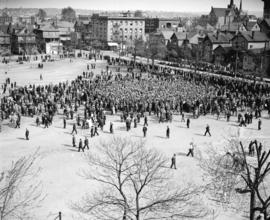
May Day demonstration crowds at Powell Street grounds
Part of Stuart Thomson fonds

May Day demonstration crowds at Powell Street grounds
Part of Stuart Thomson fonds
![[Cottages in the 200 block of Prior Street]](/uploads/r/null/6/f/6fbc5f42d07ed85e4d0089daa6235ff32bb273ccf5699745c6257ed458291e46/aa002878-4e76-4fc4-a89e-db0fb7ce4387-A09980_142.jpg)
[Cottages in the 200 block of Prior Street]
Part of Major Matthews collection
J.S. Matthews' notes with print or negative in Archives. Photograph shows 217 Prior Street, 221 Prior Street and 225 Prior Street.
![[Aerial view of Mount Pleasant, South Strathcona and Kensington-Cedar Cottage]](/uploads/r/null/7/5/75ea991fe8319eaffda79b314cbf20e281e35eb2cd8a89eaa898b492242d6282/05f856f3-0a45-41eb-94dc-46cb9d2f7ecf-A63348_142.jpg)
[Aerial view of Mount Pleasant, South Strathcona and Kensington-Cedar Cottage]
Part of Major Matthews collection
Photograph shows aerial view of the east end of False Creek, Thornton Park, Great Northern Railway and Canadian National Railway yards, Mount Pleasant, Strathcona, Grandview-Woodland, Trout Lake, Kingsway, Vancouver Technical School grounds, Renfrew playing fields, John Hendry Park, British Columbia Electric Railway Right of Way, Clark Park, Grandview Highway South, Great Northern Railway.

Part of City of Vancouver fonds
Map is an identification plan for Redevelopment Project 1, Area A-1, showing boundaries of clearance areas in Strathcona and ownership of property included in the acquisition program. Base map is bounded by Main Street, Glen Drive, Alexander Street, and Atlantic Street, and shows streets, legal descriptions, schools, parks and Canadian Pacific and Canadian National railway lines.

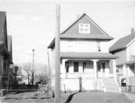
[View of one-storey house (ca 1904) at 1828 Pandora Street
Part of City of Vancouver fonds
![[View of one-storey house at 718 Pender Street]](/uploads/r/null/d/4/d42a1d4807beab8a8a2b47b83b8bf18ffb5ff0a459ee43046ea1281ca77b66d8/1ac796a9-4129-43b0-9a1c-e4c5832a01f3-A47161_142.jpg)
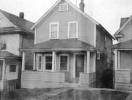
[View of one-storey house at 718 Pender Street]
Part of City of Vancouver fonds
![[Renovated ca 1900 unidentified house]](/uploads/r/null/6/2/62742109c96a1313476a93a574cc199ce735f031517e2d2466e3ff9824c31db9/423327c4-4f5d-4b74-8216-4b62af3f90b5-A47168_142.jpg)
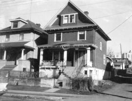
[Renovated ca 1900 unidentified house]
Part of City of Vancouver fonds
![[View of one-storey house (ca 1910) at 1022 McLean Street]](/uploads/r/null/3/f/3f4295425d37c5f20b2082b4337115928c87c1c2ef41035ef19b425b0b768386/eb91ba6c-2450-41ca-85bd-ee8b4bb36629-A47164_142.jpg)
[View of one-storey house (ca 1910) at 1022 McLean Street]
Part of City of Vancouver fonds
![[Unidentified building (store front with apartments above) and signs in vacant lot]](/uploads/r/null/0/9/09ff516660c4efe00c00ba51e057ce531f71fbfa3bc0ae60106888a750731447/9a6ee04f-b36e-4f15-bce5-4bce55435461-A47165_142.jpg)
[Unidentified building (store front with apartments above) and signs in vacant lot]
Part of City of Vancouver fonds
Billboard for Cadbury's Snack Bar chocolate bar is visible. Sign for "National Dairies fresh dairy products cash and carry drive-in Fresh milk 21¢ quart" is visible.
![[Small narrow one-storey house (ca 1900) at 722 Keefer Street]](/uploads/r/null/6/7/675c406ead1afabeff94646db5cff550ae9ee1c70e2d4f0744e890fe929f11dd/23b2265c-6a2f-42be-b509-3473be414c93-A47167_142.jpg)
[Small narrow one-storey house (ca 1900) at 722 Keefer Street]
Part of City of Vancouver fonds
![[View of "old" (ca 1904?) one storey house at 436 Union Street]](/uploads/r/null/7/e/7e4cc99f56f2209f1ea12a8a43b4d9aa0414c0fc51f0f10ee95e10da3cccc24d/d798aeee-7a4f-4d6a-8931-a0891829c9eb-A47157_142.jpg)
[View of "old" (ca 1904?) one storey house at 436 Union Street]
Part of City of Vancouver fonds
![[View of one-storey gabled house (ca 1910) at 426 Union Street]](/uploads/r/null/7/c/7c2aac9e8e5d90262ef44d7ec5a27489bddf673849302f46cc49d0900a8c95a3/46b25e2d-e1fd-4106-a52c-b6d447bd5e77-A47158_142.jpg)
[View of one-storey gabled house (ca 1910) at 426 Union Street]
Part of City of Vancouver fonds

View of "old" (ca 1909?) one storey house at 2381 Prince Albert Street
Part of City of Vancouver fonds

View of "old" (ca 1909?) one storey house at 1610 McLean Drive
Part of City of Vancouver fonds
![[View of "old" (ca 1909?) one-and-one-half storey house at 1437 East 10th Avenue]](/uploads/r/null/a/3/a3e213950ffd1528e512ce1b9921baccc2aa693b5ce31a03bdef139cc994396b/ffceb552-071c-45d4-b429-61a0979bad9b-A47153_142.jpg)
[View of "old" (ca 1909?) one-and-one-half storey house at 1437 East 10th Avenue]
Part of City of Vancouver fonds
![[View of "old" (ca 1909?) one-and-one-half storey house at 724-726 East 7th Avenue]](/uploads/r/null/8/f/8fc6a7fa0037a4e74303bdd3340afa351151dc98bbfdd72c6ad7f09bb637372a/cb5b00b6-04ed-4ded-b464-dd75d3ebac12-A47154_142.jpg)
[View of "old" (ca 1909?) one-and-one-half storey house at 724-726 East 7th Avenue]
Part of City of Vancouver fonds
![[Two one-and-one-half storey houses with pseudo-brick facades; centre one is 522 Keefer Street]](/uploads/r/null/f/6/f66c90e17db71e3fffe28c150ce85d56068f15ce668ac3fb4dcf7604ad26897f/09707d94-8fa5-495b-ad4f-d621089f407e-A47166_142.jpg)
[Two one-and-one-half storey houses with pseudo-brick facades; centre one is 522 Keefer Street]
Part of City of Vancouver fonds

View of "old" (ca 1909?) one storey house at 1655 Adanac Street
Part of City of Vancouver fonds

View of "old" (ca 1909?) one storey house at 1808 East 2nd Avenue
Part of City of Vancouver fonds
View of "old" (ca 1909?) one storey house at 817 East 8th Avenue
Part of City of Vancouver fonds
View of "old" (ca 1909?) one storey house at 2141 Pandora Street
Part of City of Vancouver fonds
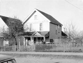
![[View of one-storey house (ca 1910) at 1737 East Pender Street]](/uploads/r/null/1/e/1e27d44555ee3c5c347719aeba156f4a8d2af3df4739df22c949edd81a800d85/3a2ee74a-fa14-4d83-ab24-5c9afc095f86-A47159_142.jpg)
[View of one-storey house (ca 1910) at 1737 East Pender Street]
Part of City of Vancouver fonds
View of "old" (ca 1909?) one storey house at 1222 Woodland Drive
Part of City of Vancouver fonds

View of "old" (ca 1909?) one storey house at 1944 Franklin Street
Part of City of Vancouver fonds
![[View of group of "old" houses at 1145, 1147 and 1149 Semlin Street]](/uploads/r/null/8/b/8bb8852928532be10dd6d90f7f199363da51dd1c4939ce022d354231cef716ba/0ae0fa63-9aca-48b2-8419-d5652e159b2c-A47152_142.jpg)
[View of group of "old" houses at 1145, 1147 and 1149 Semlin Street]
Part of City of Vancouver fonds
![[View of "old" (ca 1909?) one-and-one-half storey house at 1521 Salsbury]](/uploads/r/null/3/f/3fd3490cb8ef2a94c7780fb6ca471d706a9b64fbbc3371a0d8a7238254cdf91d/208e10b8-4bd5-4a14-b2ff-ebc8036377e5-A47155_142.jpg)
[View of "old" (ca 1909?) one-and-one-half storey house at 1521 Salsbury]
Part of City of Vancouver fonds
![[View of "old" (1904?) one storey house at 2264 Eton Street]](/uploads/r/null/6/d/6ddccc4299051cf65d4a9eb490a18cca0ed93419f677e9c0d79285705eb8d33b/f2a69844-ee5f-4ae1-81bb-6616549b6d76-A47156_142.jpg)
[View of "old" (1904?) one storey house at 2264 Eton Street]
Part of City of Vancouver fonds
![[View of three "old" houses. Centre one, 747 East Pender Street]](/uploads/r/null/1/7/179537c0d75cce724d5663ee85e640539a41908ce3ec36e97eb83605cec5749a/65f357f3-f8ac-4fc2-8149-be03f244a0ed-A47162_142.jpg)
[View of three "old" houses. Centre one, 747 East Pender Street]
Part of City of Vancouver fonds
![[One-and-one-half storey house (ca 1900) at 568 Keefer Street]](/uploads/r/null/6/e/6e548382ea3f64343f4912c1f452d14103df1962c34b3f1eee46049a81171d1b/d5a66ac5-6d4a-44d4-b155-08cbf189f0db-A47169_142.jpg)
[One-and-one-half storey house (ca 1900) at 568 Keefer Street]
Part of City of Vancouver fonds
View of "old" (ca 1909?) one storey house at 563 East 7th Avenue
Part of City of Vancouver fonds
![[View of one-storey stuccoed house (ca 1910) at 865 Prior Street]](/uploads/r/null/6/f/6f1ab1300cea4cec5c3a9ff14ff0ec963f2c6a87f9162ec014b85df60f01bbfc/3fe33b48-4a23-4636-bd5c-889a42bb17b9-A47160_142.jpg)
[View of one-storey stuccoed house (ca 1910) at 865 Prior Street]
Part of City of Vancouver fonds
![[Houses in the 700 block East Georgia Street]](/uploads/r/null/2/2/22337fc608ec5062853e0532d79dc4d241546f211cd25823171f1ccdcf1e9ac6/2afe9d8a-7fc8-461c-a57e-8d445a5cf31e-A37788_142.jpg)
[Houses in the 700 block East Georgia Street]
The third house from the left is 713 East Georgia Street.

Keefer Street and Jackson Street
Part of William Eadington Graham fonds
[Views of houses].
![[View of] Georgia St[reet]](/uploads/r/null/2/d/2de55776fa0a7eebca8462b869ccbf0ec668aed52ea363de73733f1ffa5c2674/1478fe0e-a4f1-4cb4-b9ad-175861aa84e2-A59200_142.jpg)
Part of City of Vancouver fonds
Photograph also shows the Moon Glow Cabaret
![Trading scrap yard [at] Cordova St[reet]](/uploads/r/null/3/4/34810e915ef42c2f76a16f6333500154eb58648255e2ffd83f90faa653e9e221/bdb0a8be-b05c-4b27-88b3-b99382c73afd-A59202_142.jpg)
Trading scrap yard [at] Cordova St[reet]
Part of City of Vancouver fonds
Photograph also shows railroads and cars
![[Interior view of a house in Strathcona]](/uploads/r/null/7/4/7408253a86b90ef3e5a73e51c3fc06f71359da52b00b79572fc4b086965014b3/b8f27314-b06f-4a5a-ac95-24586e388462-A59172_142.jpg)
[Interior view of a house in Strathcona]
Part of City of Vancouver fonds
![Keefer St[reet]](/uploads/r/null/6/3/63d185c55350e873db234fa8cb9e24b18dfab9ccdd4faabd4d95b3c65861a06d/fe58b53e-aecb-4d94-92e2-25de47dae562-A59179_142.jpg)
Part of City of Vancouver fonds
Photograph also shows the backs of houses and St. Mary's Ukrainian Catholic Church at 431 Princess Street
![[Corner of] Georgia [Street] and Jackson [Avenue]](/uploads/r/null/5/b/5b374ba24c6d04ebdfd6567a445fd5e5f645a5d638860041a2443410e57ca9ab/5402458e-106b-4683-9e5e-9cf278eef3b2-A59239_142.jpg)
[Corner of] Georgia [Street] and Jackson [Avenue]
Part of City of Vancouver fonds
![Lane rear [600 block East] Pender St[reet]](/uploads/r/null/9/6/96d613bbd625dfb8003f60d41776594c6936601fd4fb60e32301d80966efe3b7/614c4bcd-1fda-4a51-9048-db4ab2109739-A59165_142.jpg)
Lane rear [600 block East] Pender St[reet]
Part of City of Vancouver fonds
Photograph shows dilapidated buildings in the 600 block of East Pender between Pender and Keefer Streets looking east to the Gibb's Boys club (700 East Pender Street).
![[View of] Raymur Ave[nue]](/uploads/r/null/9/4/94763acb70dd0687d9fef35684ef97b0e92e54fdd39ab0f45b366467628a1a4c/a7e4ec7d-bee8-4dbd-a308-acd09076cd97-A59211_142.jpg)
Part of City of Vancouver fonds
Photograph also shows the Hole Trinity Russian Orthodox Church at 710 Campbell Avenue
![[Construction of] Raymur Place](/uploads/r/null/4/3/433f2d194144ab6ed2d0afa65adfa7407a6fccc557bbe06d66dd4c63d93993c8/4bf25b86-f60a-4690-997a-ff79d4162b65-A59212_142.jpg)
[Construction of] Raymur Place
Part of City of Vancouver fonds
Photograph also shows the domes of the Holy Trinity Russian Orthodox Church at 710 Campbell Avenue
![[Construction of] Raymur Place](/uploads/r/null/8/4/84f8bd414de00fbb5e4e221b1aa2a99d6a63c360e433ba7ed46be544df5dce4f/262eb4c2-fcef-4df3-82e1-5cd2b05874bf-A59213_142.jpg)
[Construction of] Raymur Place
Part of City of Vancouver fonds
Photograph also shows the domes of the Holy Trinity Russian Orthodox Church at 710 Campbell Avenue