Heritage Day celebrations at Stanley Park, with First Nations child and spectators
- VPK-S625-2---: CVA 392-1800.209
- Item
- 1986
665 results with digital objects Show results with digital objects
Heritage Day celebrations at Stanley Park, with First Nations child and spectators

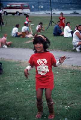
Heritage Day celebrations at Stanley Park, with First Nations child dancing on stage

Heritage Day celebrations at Stanley Park, with First Nations drummer on stage

[Heritage Day celebrations at Stanley Park, with Haida children on stage

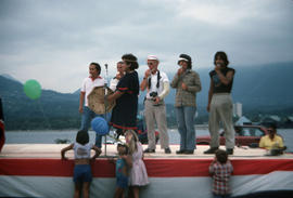
Heritage Day celebrations at Stanley Park, with mascots on stage and spectators

Heritage Day celebrations at Stanley Park, with trombone band on stage
![[Hockey player skating]](/uploads/r/null/7/a/7a05502754df0c092e2d22d6af149e6fb629d6e2944f25c51ec6e164b4c4400e/4e90362d-6478-411c-84e2-49f7615101d2-A69501_142.jpg)

Indexed guide map of Greater Vancouver and district [Proposed scenic drive]
Item is a published road map of Greater Vancouver which has been annotated to show the route of a proposed circular scenic drive route through Vancouver, Burnaby, New Westminster, Coquitlam and Port Moody, as well as a proposed arterial route connecting the Pitt River Bridge to the Vancouver road network at Boundary Road.
The proposed scenic drive follows a route along Hastings Street, Stanley Park Drive, and along the entire route of Marine Drive around the University Endowment lands and east through southern Burnaby, then north from New Westminster through Coquitlam near the Alouette River.
The two pages of textual records transferred with the map itemize the specifications for paving for each section of the road.
Vancouver Park Board
![[Indoor ball hockey rink]](/uploads/r/null/4/8/486650124a216a07e34cf8a2bd881b384ca81c7eec7c061b268d1fd2527c3809/3f535a71-7874-4e59-a08d-cb82e41a067a-A69510_142.jpg)
![[Indoor ball hockey rink]](/uploads/r/null/6/7/67173b56f02c239ae1f2d87127c3a7e13ba27ddb226fd13a80fe171db4248829/77c4e57f-cf52-4879-94b8-8cd440c5bb85-A69512_142.jpg)
![[Indoor swimming pool]](/uploads/r/null/d/a/da3fb22622a5586aa41a92e593192ce739dd8f04355d099ad7342d45032588d4/bb36823f-de86-45a8-893c-a8c34017cfe8-A69988_142.jpg)

Italian game "Bocce" takes place on Victoria Park
![Italian grandmother and her two little ones at McLean Replacement [Campbell Avenue at Union Street]](/uploads/r/null/9/6/960a78058291afef9d722585d51f784a0aab0c39436ea8cd751c9a544903f0a7/e55e257f-0156-408c-ae65-f3ab2805cff3-A44619_142.jpg)
Italian grandmother and her two little ones at McLean Replacement [Campbell Avenue at Union Street]
![[Jewellery display]](/uploads/r/null/c/6/c60adde84b5f6e775074747f236155036bc2a8d4e4f36a0f351139ee71aeb3f9/c50b76b3-a0ce-46ce-8630-926ae1bc8105-A69562_142.jpg)
![[Karate class]](/uploads/r/null/b/c/bcf2e4accccffacc5c09a329b39e694e30444f5f47c8a892f8908acc8019b08b/759a12b7-ed8e-44e2-b6e1-f97b2f15a413-A69524_142.jpg)
![[Karate sparring in front of a crowd]](/uploads/r/null/2/c/2c9fb283538de94b3d7526ce5213d569b6cde90f2c0b1f572d573f23efd16f63/4f34f347-d510-4868-b0ee-61e017fed0e1-A69544_142.jpg)
[Karate sparring in front of a crowd]
![[Kayakers in indoor pool]](/uploads/r/null/7/a/7a1f8adba754398187f2e94a37761bccb0c59c5bb5532399ace620f51a4a1288/3f2e393d-3dbe-4b37-a076-fba66351966d-A69992_142.jpg)
![[Kerrisdale Community Centre exterior]](/uploads/r/null/c/0/c0d2cc3559fde58aaf6aff6d1bf33f74c0996eb691186dd4933ec99a5f8ae477/1111cf04-0055-453a-a111-14c8bf259968-A69537_142.jpg)
[Kerrisdale Community Centre exterior]
![[Kid and adults with skis beside snowbank and bus]](/uploads/r/null/a/d/ad98ec9d7b8e0e3e9437f7fb9a3bf0d226e9aba1757ba929e34adadcaffb631f/180f4db1-f58f-4765-bc65-7204f07c104a-A69858_142.jpg)
[Kid and adults with skis beside snowbank and bus]
![[Kids in playground with a slide]](/uploads/r/null/9/1/915c452fcd88a41e0c43247302c155f35b1b7227b648d3ac3d725b0ae2aa3327/b101413a-e837-42de-a514-9ba91b1696c0-A69846_142.jpg)
[Kids in playground with a slide]
![[Kids in wheelchairs on ferry]](/uploads/r/null/3/a/3ad1be65575cb48d9e69aaec2890e60785e7be393f744d5141d4374564fb9857/4f44ea53-09e2-4a2a-adb0-ec926c55aadb-A69696_142.jpg)
[Kids in wheelchairs on ferry]
![[Kids on rope ladder above inflatable mat]](/uploads/r/null/0/2/02945e8db46538bb3113e695b80ef38585deda088a5e0d02436ac662010a0f47/a543f2f5-9597-4775-9f84-127ba3ca7938-A70044_142.jpg)
[Kids on rope ladder above inflatable mat]
![[Kids sitting on concrete stoop]](/uploads/r/null/c/b/cb4f069cae580c099434fb8f921fc3eb8faf93a90993fdf38376b79291030f02/d85b25a1-cdc8-4b6d-861f-acd427ecbfdb-A69708_142.jpg)
[Kids sitting on concrete stoop]
![[Kids with floatation devices in swimming pool]](/uploads/r/null/7/9/79f701e2809d139a1db2bc4fe2994b0ca292329d9adabb28f3bba12b7cab3777/20b1f018-814b-408b-99be-720af06b59ed-A69985_142.jpg)
[Kids with floatation devices in swimming pool]
![[Kids with punching bags]](/uploads/r/null/2/a/2a1ab28424e0198d241e2cea2cd77682b0bd76e0694ee8a29c639ac752b171e6/986cebf8-2364-48b1-bd88-2842b232b80f-A70050_142.jpg)
![[Killarney Community Centre craft booth]](/uploads/r/null/c/f/cfc6138b45d727a3fcd0f342af4f1e023265100e25e097127d4f3357949396ae/4ce46e59-8b95-4dfd-ab8e-31c2dde1daec-A69508_142.jpg)
[Killarney Community Centre craft booth]
Kitsilano Beach swimming pool bleachers and pool walls details
Item is an architectural drawing that depicts plans and sections.
Vancouver Park Board

Kitsilano Beach Vancouver [survey]

Kitsilano Park : steps at end of bleachers
Item is an architectural drawing that depicts plans and sections.
Vancouver Park Board
Vancouver Park Board
Item is an architectural drawing that depicts plans and sections.
Vancouver Park Board

Large sailboat in Burrard Inlet with Stanley Park in background

Large sailboat with children in Burrard Inlet

Lavatory west end of Kitsilano pool
Item is an architectural drawing that depicts plans, sections and elevations.
Vancouver Park Board
![[Little boy on rope swing]](/uploads/r/null/b/1/b10577c774ee987f1f8f8c7c888e85b292abdaef114ad1434138feda5089314d/e391ba8a-91fa-4c4f-b6ba-c8de6bb416e7-A69497_142.jpg)


MacLean Park Housing Project building under construction
![[Man and group of children with left arms raised]](/uploads/r/null/f/1/f1db7164daf145aa4628cf326922bda39e882ab226ba008cd75a1ecc33b7ef15/36a7ed24-244a-4760-961c-166b21853379-A69999_142.jpg)
[Man and group of children with left arms raised]
![[Man and woman playing with boy in wheelchair]](/uploads/r/null/6/e/6e3dcbda742d365a56e22feb9e7c24dffa4df5cd3305027cc3739c455159ccf9/104fe4a5-891d-429a-9e32-98e1b49a0a90-A69880_142.jpg)
[Man and woman playing with boy in wheelchair]
![[Man approaching diving board]](/uploads/r/null/e/3/e3e6fa7f2c70a365218671e16585bbe821ea040d790e2e5227843b485d432aa2/0648b562-ed8b-4273-a4d8-4150d765bf5c-A69997_142.jpg)
[Man approaching diving board]
![[Man assisting child in ice sledge]](/uploads/r/null/3/7/3716daf484c3100d1f1968d234fa80afdaef61333fe0cf0f6cc3fc5dd6b090d9/0c71e648-fb8d-4268-8d44-5a547fbe3e5b-A69709_142.jpg)
[Man assisting child in ice sledge]
![[Man at Pacific National Exhibition sports camp snack table]](/uploads/r/null/1/f/1f3eca918bd0bb11440e64c669e87b497ed4cbb8889cf22cda2e62c690d07f66/de26766c-25dc-4e4e-b246-cc889a751f48-A69782_142.jpg)
[Man at Pacific National Exhibition sports camp snack table]
![[Man giving darts to children in costumes]](/uploads/r/null/4/b/4b439d00655f774ec6835689d2c9e4a0b722070ae6f912895af4a23dd70213a9/59b72e92-3e1f-44bd-8116-7e37540d8a52-A69769_142.jpg)
[Man giving darts to children in costumes]
![[Man helping boy with archery]](/uploads/r/null/0/3/034666bb80cbcfdd767abe0b777cd39111fc21f585979fdcbf00af28e784d07e/c71f411a-aa7e-43c1-aefc-912bd585eeaf-A69766_142.jpg)
[Man helping boy with archery]
![[Man helping boy with water wings float]](/uploads/r/null/e/f/eff77b20c0a7b07bddb7f1cc170c511cc427e055c8287ae6c029f111432dc7da/454c59c0-f642-4d6c-86a8-476e05a2ac67-A69971_142.jpg)
[Man helping boy with water wings float]
![[Man helping girl shoot a bow and arrow]](/uploads/r/null/1/d/1da4813f64ea5e92f856eefc53a131f2290813f443f64a4ae582e7d7d397bedc/dea1b200-3327-46f9-bf92-5310e81a56ef-A69962_142.jpg)
[Man helping girl shoot a bow and arrow]