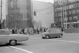
Item part is a photograph of Pacific Centre plaza at the intersection of W. Georgia Street and Granville Street, looking west from the corner of the Hudson's Bay Company building (674 Granville Street) diagonally across the intersection. The Eaton's Building (701 Granville Street) is visible on the left of the plaza and the Toronto Dominion Bank tower (700 W. Georgia Street) is on the right.
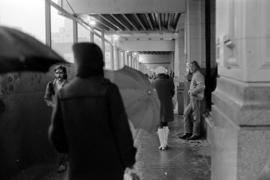
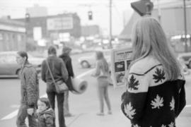
Item part is a photograph of pedestrians on en enclosed Granville Street a sidewalk near the intersection of Granville Street and W. Georgia Street. The sidewalk is enclosed with a temporary construction enclosure on the Granville Street side and the under the awning and northwest side of the Hudson's Bay Company building (674 Granville Street).
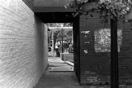
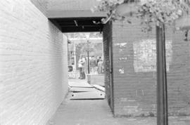
Item is a photograph of a view through an alley entrance to Gaolers Mews, just south of Guenter's Delicatessen (203 Carrall Street), Maple Tree Square, Gastown.
Item part is a photograph of a view through an alley entrance to Gaolers Mews, just south of Guenter's Delicatessen (203 Carrall Street), Maple Tree Square, Gastown.
Item part is a photograph of the entrance to the collection of shops at The Garage (12 Water Street). On the left is Graphic House printers, on the right is Chocolate Factory candy, and in the centre background is the Serenite Restaurant.
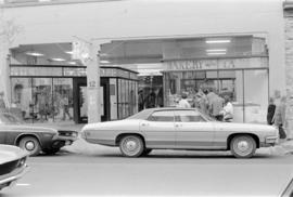
Item part is a photograph of the sidewalk, awnings, entrance, and front window displays of the European News & Import House store (1044 Robson Street) with cars parked in front, taken from across Robson Street. "Scandinavian News Centre" is written on the awning.
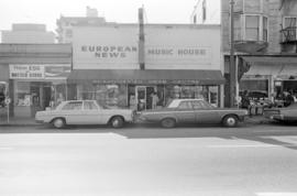
Item part is a photograph of storefronts on Robson Street focusing on the European News & Import House store (1044 Robson Street) and including a Fresh Egg and Butter Store to the left, and Standard Produce Co. (1052 Robson Street) to the right. "Scandinavian News Centre" is written on the awning.
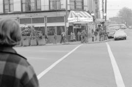
Item part is a photograph of an evangelist on the sidewalk of W. Georgia Street between Granville Street and Seymour Street. The awning of the Hudson's Bay Company building (674 Granville Street) is visible above the sidewalk and The Strand theatre (600 W. Georgia Street) is visible across the street.
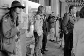
Item part is a photograph of evangelists and a violin playing busker under the awning of the Hudson's Bay Company building (674 Granville Street) near the intersection of Granville Street and W. Georgia Street.
Item part is a photograph of evangelists and a violin playing busker under the awning of the Hudson's Bay Company building (674 Granville Street) near the intersection of Granville Street and W. Georgia Street.
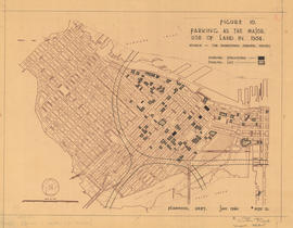
Map is a plan of downtown Vancouver showing parking structures and parking lots in the area between Jervis Street and Main Street and Burrard Inlet and Nelson Street. The source of the map is indicated as 'The Downtown Parking Report'. Note written in the bottom right corner of the map reads "B 1960 Jan., Traffic Plans, small folder."
Map is a plan of downtown Vancouver showing parking structures and parking lots in the area between Jervis Street and Main Street and Burrard Inlet and Nelson Street. The source of the map is indicated as an aerial photograph taken April 1959. Note written in the bottom right corner of the map reads "B 1960 Jan., Traffic Plans, small folder."
Map is a plan of downtown Vancouver showing parking structures and parking lots in the area between Jervis Street and Main Street and Burrard Inlet and Nelson Street. The source of the map is indicated as 'parking supply and demand projections, September 1959'. Note written in the bottom right corner of the map reads "B 1960 Jan., Traffic Plans, small folder."
Map is a plan of downtown Vancouver with areas shaded to indicate streets, squares, malls and arcades, in which the movement of vehicles is not permitted at all or is restricted. Although the entire downtown area is shown, shading pertains only to Jervis Street and Main Street and Burrard Inlet and Nelson Street. Note written in the bottom right corner of the map reads "B 1960 Jan., Traffic Plans, small folder."
Item part is a photograph of sidewalk and storefronts on Robson Street with an unidentified clothing shop's front window display visible in the foreground and the Freybe Delicatessen (1085 Robson Street) signage further up the street. The Sheraton Landmark hotel is visible in the background.
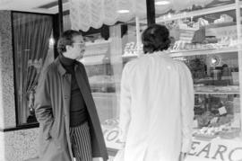
Item part is a photograph of the front window of June Curtis Fashion Jewellery (1077 Robson Street). Freybe Delicatessen (1085 Robson Street) sign is visible in the background.
Item part is a photograph of pedestrians on the sidewalk walking past double arches marking the entrance and exit to a Gastown parking area, a sign indicates "Woodward's parking". John Damer & Son Ltd. signage is visible in the background.
Item is a set of negatives of street photography scenes in Gastown. The identified street views begin near Maple Tree Square, at Alexander Street and Water Street, and continue west down Water Street to Cambie Street and then south to the Cambie Street and Cordova Street intersection. The photograph subjects are everyday street scenes, predominantly storefronts of local businesses and pedestrians on the sidewalk. This set contains the raw photographs from the roll the photographer shot in their original order. The associated contact sheet has selection marks for frames 2, 9, 14, and 28.
Item is a set of negatives of street photography scenes in Gastown. The identified areas are Maple Tree Square and the section of Water Street immediately adjacent to it. The photograph subjects are everyday street scenes, predominantly storefronts of local businesses and pedestrians on the sidewalk. This set contains the raw photographs from the roll the photographer shot in their original order. The associated contact sheet has selection marks for frame 11.
Item is a set of negatives of street photography scenes in Gastown. The identified street views begin on Water Street near Cambie Street and continue east down Water Street to Maple Tree Square. The photograph subjects are everyday street scenes, predominantly storefronts of local businesses and pedestrians on the sidewalk. This set contains the raw photographs from the roll the photographer shot in their original order. The associated contact sheet has selection marks for frames 10A and 33A.
Item part is a photograph of a girl selling magazines on the sidewalk at the northwest corner (Robson Street side) of the Vancouver Public Library (750 Burrard Street) near Burrard Street and Robson Street
Item part is a photograph of the Granville entertainment district from the intersection of Robson Street and Granville Street, looking southwest down Granville Street. Visible in the photograph are automobiles and pedestrians, as well as signs for Capital Theatre (820 Granville Street), Mr. Jakes Charbroiled Steaks (831 Granville Street), Coronet Theatre (851 Granville Street), Odeon Theatre (881 Granville Street), Orpheum theatre (884 Granville Street), Vogue Theatre (918 Granville Street), and James Furniture.
Item part is a photograph of the Granville entertainment district from the intersection of Robson Street and Granville Street, looking southwest down Granville Street. Visible in the photograph are automobiles and pedestrians, as well as signs for Mr. Jakes Charbroiled Steaks (831 Granville Street), the Orpheum (884 Granville Street), and the Vogue Theatre (918 Granville Street).


![[Exterior view of the] Rogers Building at 470 Granville [Street]](/uploads/r/null/4/6/46adbf6de86563ba2801897f647aeec25ac060dc7aaec2f768c50b1ef535ff0c/96b3499c-9b58-48ef-bd7b-1103447affaa-A58791_142.jpg)


![Granville Mall - Mayor starts work [1 of 14]](/uploads/r/null/d/8/d8de9a60aa7672412e3c32838c09c96eec65ed01c4d402622f3b4a4c5b4d1d0d/ca3359e5-c79a-40c7-9023-c8aac72b8283-A64462_142.jpg)
![Granville Mall - Mayor starts work [10 of 14]](/uploads/r/null/8/7/8717858c3c9f1eebdd2b0789e91726b65cac49f881c3083401f370774a98ac78/7286a08f-f6fc-4761-bfa5-3d06eb02fabc-A64473_142.jpg)
![Granville Mall - Mayor starts work [11 of 14]](/uploads/r/null/6/7/675394d4dc61cb0165a864a84eb04f06086c156ccc51e1c477be4fc06ce40398/1ccf0b23-5eb8-44e9-89f2-367394e14486-A64474_142.jpg)
![Granville Mall - Mayor starts work [12 of 14]](/uploads/r/null/1/7/1718b3a25451eeaeaea3d2ceac894f48af3191c2166a6986af009036b41ca699/33ec04c5-1448-4be5-89c3-bf2dc8804754-A64475_142.jpg)
![Granville Mall - Mayor starts work [13 of 14]](/uploads/r/null/7/8/7813f107379117b1f2c90df5269984af5db88471b51f3137ad91e6553c191a97/5b817885-ff30-4abb-be9d-52740f8d4338-A64476_142.jpg)
![Granville Mall - Mayor starts work [14 of 14]](/uploads/r/null/a/7/a707c43e450e1d31d4cc431831c6254fc8769b3589cf1e585e85bc6d4f3cf3d4/678bb207-16e2-42cb-ad17-004c68883ed3-A64477_142.jpg)
![Granville Mall - Mayor starts work [2 of 14]](/uploads/r/null/8/c/8cd3847950535c79f6cfa0c7482d6694f778afe701a5c7ddaf9d1ddb546c51c6/ecdb62e5-9385-4f4e-aa4d-38c0161ae4aa-A64463_142.jpg)
![Granville Mall - Mayor starts work [3 of 14]](/uploads/r/null/e/0/e0fdebff8e797fe8ef9452fdd6b28dce8531d8669dc671f6ec83c7295c5a7e35/a2557990-da90-490d-8cf1-cb27682a872a-A64464_142.jpg)
![Granville Mall - Mayor starts work [4 of 14]](/uploads/r/null/5/9/5962df82933df5de5eb9cdc143821a61c96762326b7512ad780172af0692fb03/15aa9735-61b9-44ed-b27b-b64846159620-A64465_142.jpg)
![Granville Mall - Mayor starts work [5 of 14]](/uploads/r/null/3/c/3c9a043e6f60a7b3724ef695f0574f3b8bf792faf7f6c6673140bc90a4f42135/2282fdb4-8659-4285-b6da-a75b2028242f-A64466_142.jpg)
![Granville Mall - Mayor starts work [6 of 14]](/uploads/r/null/6/7/678cbeb94f552d8afb2fc5b07950ec1f5a804de89edc664c3ccbda418bdb244e/a29ff4df-09fc-4cb4-8e08-ad36e26df13b-A64469_142.jpg)
![Granville Mall - Mayor starts work [7 of 14]](/uploads/r/null/a/e/aebc9b53603051d51cbfe4f864f67450401cc34084c8f1191140224036a06974/7c09a171-9073-4e04-adc9-390d5d5c88d5-A64470_142.jpg)