1919 addition [Mountain View Cemetery]
- COV-S153-: LEG1968.04
- Item
- Jan. 1919
Part of City of Vancouver fonds
Vancouver (B.C.). Engineer's Office
34 results with digital objects Show results with digital objects
1919 addition [Mountain View Cemetery]
Part of City of Vancouver fonds
Vancouver (B.C.). Engineer's Office

4th Ave & Granville St. convenience
Part of City of Vancouver fonds
Item is an architectural drawing showing two views of the proposed convenience: a cross section and elevation to Granville St.
Vancouver (B.C.). Engineer's Office
Arms of H.R.H. Princess Elizabeth
Part of City of Vancouver fonds
Item is a painting of the coat of arms of H.R.H. Princess Elizabeth, presumably made in relation to the Royal Visit of H.R.H. Princess Elizabeth and the Duke of Edinburgh in October 1951.
Vancouver (B.C.). Engineer's Office
Part of City of Vancouver fonds
Item is a painting of the coat of arms of the Duke of Edinburgh, presumably made in relation to the Royal Visit of H.R.H. Princess Elizabeth and the Duke of Edinburgh in October 1951.
Vancouver (B.C.). Engineer's Office
City of Vancouver traffic signal timing
Part of City of Vancouver fonds
Item is a chart showing traffic signal timing at various intersections across Vancouver.
Vancouver (B.C.). Engineer's Office
Part of City of Vancouver fonds
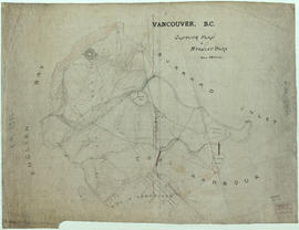
Item is a topographical map of Stanley Park showing various landmarks and locations of buildings.
Vancouver (B.C.). Engineer's Office
Crest for Good Roads League of British Columbia-version 1
Part of City of Vancouver fonds
Vancouver (B.C.). Engineer's Office
Crest for Good Roads League of British Columbia-version 2
Part of City of Vancouver fonds
Vancouver (B.C.). Engineer's Office

Part of City of Vancouver fonds
Item is an architectural drawing depicting construction details a public toilet building, including designations for materials to be used.
Vancouver (B.C.). Engineer's Office

Development of railway properties at 1st Avenue and Main Street
Part of City of Vancouver fonds
Item is a map depicting proposed street and park developments along Main Street between 1st Avenue and Prior Street.
Vancouver (B.C.). Engineer's Office

Drainage and electrical wiring plan, for public convenience, Hamilton Street, Vancouver B.C.
Part of City of Vancouver fonds
Item is an architectural drawing showing plans for public washrooms on Hamilton Street, between Pender Street and Hastings Street in downtown Vancouver, B.C. The drawing includes a floor plan, a longitudinal section, a plan of the sidewalk top, and a location plan. Drain, vent pipes, and electric wiring are shown.
Vancouver (B.C.). Engineer's Office
![False Creek development : san [sanitary] sewers tentative layout](/uploads/r/null/c/a/ca111eaa497f59a66ecdad4c91bfb2238f21efb21b91a1172f460ef16667055f/4da08847-7457-4d4c-8938-e4c6c1dc50c3-MAP692_142.jpg)
False Creek development : san [sanitary] sewers tentative layout
Part of City of Vancouver fonds
Item is a copy of a sheet from a sectional map of Vancouver which has been annotated to show the proposed locations of sanitary sewers in the area from Keefer Street in the north to 3rd Avenue in the south and from Clark Drive in the east to Ontario Street in the west.
Vancouver (B.C.). Engineer's Office

Floor plan and elevation of toilets
Part of City of Vancouver fonds
Item is an architectural drawing depicting the design of a potential public toilets building. Drawing includes floor plan and elevation.
Vancouver (B.C.). Engineer's Office
Greenery arch erected at Granville and Hastings Streets
Part of City of Vancouver fonds
Item consists of an architectural drawing of the ceremonial arch erected for the Prince of Wales' visit to Vancouver. The drawing depicts a front elevation.
Vancouver (B.C.). Engineer's Office

Mercury incandescant standards for the park roadway
Part of City of Vancouver fonds
Vancouver (B.C.). Engineer's Office

Plan and profile of 4th Avenue from Lakewood Dr. to Templeton Dr.
Part of City of Vancouver fonds
Vancouver (B.C.). Engineer's Office
Plan of arch to be erected on Georgia Street for the Diamond Jubilee celebration
Part of City of Vancouver fonds
Item is an architectural drawing of a ceremonial arch erected for the the Diamond Jubilee celebrations. The drawing depicts plans, elevations and details.
Vancouver (B.C.). Engineer's Office

Plan of City float 1st July parade 1926
Part of City of Vancouver fonds
Item is a design drawing for a parade float, including plan, side elevation and front elevations.
Vancouver (B.C.). Engineer's Office
![Plan of converted 4-piece square base standard [street light]](/uploads/r/null/a/6/2/a620fe2056a7ce78337e51da4b09cb570db33a6089213c0e6f07948cc8135f4c/279b1696-21a7-4cf7-9129-75bc5b98fced-LEG1967_142.jpg)
Plan of converted 4-piece square base standard [street light]
Part of City of Vancouver fonds
Vancouver (B.C.). Engineer's Office

Plan of occupations at Forty-second Avenue and Yew Street
Part of City of Vancouver fonds
Item is a site plan of the former Point Grey Municipal Yards and Municipal Hall, showing the location and use of various buildings on the site.
Vancouver (B.C.). Engineer's Office

Plan of Paterson's property, block 364 D.L. 562, City of Vancouver, B.C.
Part of City of Vancouver fonds
Item is a site plan of a lumber yard in the block bounded by Arbutus Street, Tenth Avenue, Yes Street, and Eleventh Avenue. The map shows the location and usage of buildings on the site and the location of the B.C. Electric Railway spur line on the site.
Vancouver (B.C.). Engineer's Office
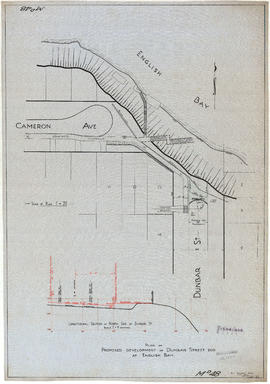
Plan of proposed development of Dunbar Street end at English Bay
Part of City of Vancouver fonds
Item is a technical drawing containing a plan of proposed developments at the north end of Dunbar Street, including walkways, piers and road re-grading. The drawing also includes a longitudinal section showing proposed works along Dunbar Street.
Vancouver (B.C.). Engineer's Office

Plan of proposed public convenience, Georgia & Granville Sts., Vancouver, B.C.
Part of City of Vancouver fonds
Item is an architectural drawing of a public toilet and includes a floor plan, longitudinal section, and location plan.
Vancouver (B.C.). Engineer's Office

Plan of public convenience, Hamilton Street, Vancouver B.C.
Part of City of Vancouver fonds
Item is an architectural drawing showing plans for public washrooms on Hamilton Street, between Pender Street and Hastings Street in downtown Vancouver, B.C. The drawing includes a floor plan, a longitudinal section, a plan of the sidewalk top, and a location plan, which include notes about construction and building materials.
Vancouver (B.C.). Engineer's Office
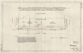
Plan showing proposed pavement widening for parking purposes
Part of City of Vancouver fonds
Vancouver (B.C.). Engineer's Office
Plan showing typical cross-section of proposed pavement on Woodland Drive, Vancouver B.C.
Part of City of Vancouver fonds
Item is a technical drawing depicting a typical cross section and detailed section of pavement, curb and gutters.
Vancouver (B.C.). Engineer's Office
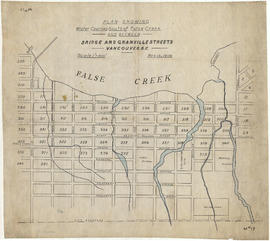
Plan showing water courses south of False Creek and between Bridge and Granville Street
Part of City of Vancouver fonds
Item is a map showing the location of historical creeks and streams in the Fairview area feeding into False Creek from the south, from Bridge [Cambie] Street to Granville Street, and north of 14th Avenue.
Vancouver (B.C.). Engineer's Office

Part of City of Vancouver fonds
Vancouver (B.C.). Engineer's Office

Proposed convenience at Kingsway & Main St.
Part of City of Vancouver fonds
Item is an architectural drawing of an underground public toilet facility. Drawing includes pans and cross-sections.
Vancouver (B.C.). Engineer's Office

Proposed convenience at south end of Granville Bridge
Part of City of Vancouver fonds
Item is an architectural drawing showing three views of the proposed convenience: elevation to Granville St. Bridge, underground plan, and plan on bridge elevation.
Vancouver (B.C.). Engineer's Office
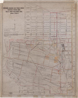
Proposed Raymur Ave. trunk sewer diverting sewage from False Creek reclaimed area
Part of City of Vancouver fonds
Item is a map showing detailed plans associated with the Raymur Ave. trunk sewer. The map contains several revisions and updates dated Dec. 1936, Feb. and Mar. 1937, May 1937, Aug. 1938 and Sept. 1941 of utilities infrastructure in False Creek east of Main Street.
Vancouver (B.C.). Engineer's Office

Proposed Raymur Ave. trunk sewer diverting sewage from False Creek reclaimed area
Part of City of Vancouver fonds
Item is a map showing detailed plans associated with the Raymur Ave. trunk sewer. Annotations show the heights of top fill, bottom and water relative to an unidentified benchmark.
Vancouver (B.C.). Engineer's Office

Proposed Raymur Ave. trunk sewer diverting sewage from False Creek reclaimed area
Part of City of Vancouver fonds
Item is a map showing detailed plans associated with the Raymur Ave. trunk sewer. Annotations show sewer lines.
Vancouver (B.C.). Engineer's Office
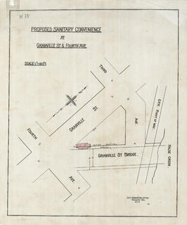
Proposed sanitary convenience at Granville Street & Fourth Avenue
Part of City of Vancouver fonds
Item is an architectural drawing depicting a proposed public toilet near Granville St. and Fourth Ave. The drawing depicts a site plan.
Vancouver (B.C.). Engineer's Office

Proposed sanitary convenience at S. end of Granville Bridge
Part of City of Vancouver fonds
Item consists of an architectural drawing depicting design of a public toilet to be erected at the south end of Granville Bridge. The sheet depicts the front and rear elevations.
Vancouver (B.C.). Engineer's Office

Proposed sanitary convenience at S. end of Granville Bridge
Part of City of Vancouver fonds
Item consists of an architectural drawings depicting the design of a public toilet to be located at the south end of the Granville Street Bridge. Drawing depicts cross section and longitudinal section of the building.
Vancouver (B.C.). Engineer's Office
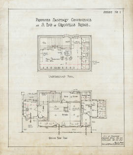
Proposed sanitary convenience at S. end of Granville Bridge.
Part of City of Vancouver fonds
Item consists of an architectural drawing depicting floor plans of the proposed building.
Vancouver (B.C.). Engineer's Office

Proposed sanitary convenience at S. end of Granville Bridge
Part of City of Vancouver fonds
Item consists of an architectural drawing depicting the design of a public toilet located at the south end of the Granville Street Bridge. The drawing depicts a side (end) elevation and location plan.
Vancouver (B.C.). Engineer's Office

Proposed sanitary convenience Fourth Ave & Granville St
Part of City of Vancouver fonds
Item is an architectural drawing showing views of the proposed convenience: plan of ground floor, elevation to Granville Bridge, plan of basement, and cross section.
Vancouver (B.C.). Engineer's Office

Proposed store and sanitary convenience at S. end of Granville Bridge
Part of City of Vancouver fonds
Item is an architectural drawing depicting the design of a proposed public toilet facility and store. The drawing depicts the Granville Street elevation.
Vancouver (B.C.). Engineer's Office

Reinforced concrete details, Hamilton Street convenience
Part of City of Vancouver fonds
Item is an architectural drawing showing details regarding the reinforced concrete for public washrooms on Hamilton Street, downtown Vancouver, B.C.
Vancouver (B.C.). Engineer's Office
Renfrew Heights subdivision plans
Part of City of Vancouver fonds
File consists of maps showing the development of the street grid in the Renfre Heights area, as well as proposals for certain commercial developments.
Vancouver (B.C.). Engineer's Office
Part of City of Vancouver fonds
Item is a drawing of a City truck. An annotation in J.S. Matthews' hand states that the drawing was made for a colour scheme for City vehicles.
Vancouver (B.C.). Engineer's Office

The official street name map of the City of Vancouver
Part of City of Vancouver fonds
Item is a map created to accompany a street naming by-law.
Vancouver (B.C.). Engineer's Office
Traffic regulator [intersection signal]
Part of City of Vancouver fonds
Vancouver (B.C.). Engineer's Office

Viaduct from Burrard Bridgehead to Arbutus St. at 6th Ave
Part of City of Vancouver fonds
Item is a technical drawing which depicts an oblique aerial view of the south end of the Burrard Street Bridge and surrounding area, with a design for a proposed viaduct running from the south bridgehead south-westward over Kitsilano to Arbutus Street.
Vancouver (B.C.). Engineer's Office