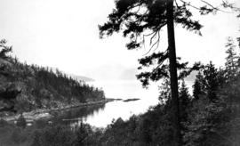
![[Looking east towards Prospect Point]](/uploads/r/null/3/5/353b1aa08c35d1d8b5089e30dbf1e7cbd7be47afb7288ca95f34e01df15f3530/0799ffa0-869e-459b-8fdc-d783d59aef7c-A49523_142.jpg)
[Looking east towards Prospect Point]
- AM54-S4-2-: CVA 371-2038
- Item
- 1899
Part of Major Matthews collection
580 results directly related Exclude narrower terms
[Looking east towards Prospect Point]
Part of Major Matthews collection

Part of Major Matthews collection
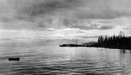
Looking north from east bank above Horseshoe Bay
Part of Samuel H. Logan fonds
![[Looking south at the undeveloped British Pacific Properties]](/uploads/r/null/6/5/65f8722b97085517c0cd2ec4aa1c748b6f2f9e371c28f8eed6a5fa7e965a95cd/fcd2fc12-d909-4bcb-8757-be64af017b25-A43270_142.jpg)
[Looking south at the undeveloped British Pacific Properties]
Part of Major Matthews collection
Photograph shows the Lion's Gate Bridge and Vancouver in the background

Part of Major Matthews collection

Looking up Lawson Avenue Hollyburne B.C.
Part of Major Matthews collection
Photograph shows a view up 17th Avenue from the Dominion Government Wharf
Looking west from North Vancouver towards Cypress Point Cannery
Part of Samuel H. Logan fonds
![Mae and Ralph [Nickson]](/uploads/r/null/6/6/9/669a7d7deb9330f7c58e9e331d8379d3837bc981cec65ab6e9a5ea2db8ccca9a/890ed465-9809-4cf5-9beb-c1020dc16160-CVA289-002_142.jpg)
Part of William Orson Banfield fonds
![Mae [Nickson]](/uploads/r/null/6/6/f/66f46a665ee24bc8352c2192c7605dfdfc072c1e419ab0e399c26e1f14a6b067/06e3d83d-efff-452a-bfb4-b34f7b617679-CVA289-002_142.jpg)
Part of William Orson Banfield fonds
![Mae [Nickson]](/uploads/r/null/c/3/7/c3747ad9c8443880479336f1bb2be41d69588ce826b78b765aea83be0d7ba9a6/688fc2ca-963a-4acf-976a-cfec9a34ed96-CVA289-002_142.jpg)
Part of William Orson Banfield fonds
![Mae [Nickson] and Lois [and two men]](/uploads/r/null/c/c/2/cc21217347899a234f326138d5ef7cb179cb19f1ca1433a06e96a20ba40cb2ee/fc756ed3-42b7-4a11-ac72-45106731e6a4-CVA289-002_142.jpg)
Mae [Nickson] and Lois [and two men]
Part of William Orson Banfield fonds
![Mae [Nickson] and Ruth Purdy](/uploads/r/null/b/7/8/b78a5745d57a2810802e892c0088b728fd1c543d06fb047607de478830841838/8ecb1969-f6fa-44d3-b786-6b3179ced809-CVA289-002_142.jpg)
Part of William Orson Banfield fonds
![Mae [Nickson] in Cypress Creek](/uploads/r/null/1/5/9/159fdca696edc273de741f6b465c787b48434181d4291b3afa121dbc18b0c74d/f712e331-1896-40f4-85e8-191c05b98773-CVA289-002_142.jpg)
Mae [Nickson] in Cypress Creek
Part of William Orson Banfield fonds
![Mae [Nickson] on Cypress Creek](/uploads/r/null/7/1/c/71c29b8c7cab0d107c00cd4fe148de171f3a7d20cf26eefff60f344c219b1be4/3c94e7b8-6d82-411e-968e-e039c50a83ad-CVA289-002_142.jpg)
Mae [Nickson] on Cypress Creek
Part of William Orson Banfield fonds
![Mae [Nickson] pensive](/uploads/r/null/9/1/9/919aa606a6b9c6a280067e3185625c4feb1ba1cce305100319e86fc8d55a7576/aac4fa4d-9b47-40a2-b1cc-907dca6f7bef-CVA289-002_142.jpg)
Part of William Orson Banfield fonds
![Mae [Nickson,] Ruth [Purdy] etc.](/uploads/r/null/4/8/f/48ffd620e1f31544728eb0a0b1b7590ba522c7b880d7b0b3d01d655cb0dc66eb/e77817f2-3f7b-4965-be13-c8464ae8704a-CVA289-002_142.jpg)
Mae [Nickson,] Ruth [Purdy] etc.
Part of William Orson Banfield fonds
Part of C.B.K. Van Norman fonds
File consists of the following types of architectural drawings: elevations, floor plans and structural specifications. The file documents two projects: the design of a single-family residence on the site, then a later re-development replacing that house with a multi-unit building containing a unit for Mrs Ross. None of the drawings for the later project are dated or have a job no.

Part of William Orson Banfield fonds
![[Man building skid sleigh for Capilano Timber Company on future site of the British Properties]](/uploads/r/null/2/1/214df9287d14ddc0647b29014c4bb9e9a52c9aef9006bf742355d1fcaedd9218/4bee27e7-94f8-49f4-922e-200730d22b0c-A31967_142.jpg)
[Man building skid sleigh for Capilano Timber Company on future site of the British Properties]
Part of Major Matthews collection

Map of portion New Westminster District
Part of City of Vancouver Archives technical and cartographic drawing collection
Item is a heavily-amended copy of a map illustrating intended land settlement and subdivision in 1877 in the future sites of Vancouver, Burnaby and the North Shore, from an area bordering on English Bay to an area bordering on North Arm. Also shown are bodies of water, Hastings & Granville Road, and the settlements of Hastings and Granville. Annotations by J.S. Matthews in 1954 made on the copy are tracings in white pen and darkening the background to improve the copy.

Map of portion New Westminster District
Part of Major Matthews collection
Item is an annotated tracing of a map showing the future sites of Vancouver, Burnaby and the North Shore from an area bordering on English Bay to an area bordering on North Arm. Traced over by J.S. Matthews in 1954, it illustrates intended land settlement and subdivision in 1877. Also shown are bodies of water, Hastings & Granville Road, and the settlements of Hastings and Granville. Annotations are an introductory note by Matthews in August 1954 titled "Before Greater Vancouver." Enclosed with the map are four letters between J.S. Matthews and W.H. Hutchinson, Chief of the Geographic Division of the B.C. Survey and Mapping Branch of the Department of Lands and Forests, in 1954 concerning the map's provenance and Matthew's efforts to increase the legibility of copies of the original map.
Map of Vancouver, North Vancouver, and West Vancouver

Part of City of Vancouver Archives technical and cartographic drawing collection
Part contains an illustrated map of West Vancouver and North Vancouver showing major streets, mountains, rivers and creeks, and recreational attractions; a street index to the Greater Vancouver map on the other side of the sheet; a list of golf courses; and real estate information including a description of professional realtors, an amortization table, and calculations showing amounts paid in rent over many years.

Map of West Vancouver and vicinity
Part of City of Vancouver Archives technical and cartographic drawing collection
Part contains a map of West Vancouver, North Vancouver, and the northern parts of Vancouver and Burnaby. Map shows district lot and block numbers, streets, and distances from City Hall.
Map of West Vancouver and vicinity
Part of City of Vancouver Archives technical and cartographic drawing collection
Item is a map of West Vancouver, North Vancouver, and the northern parts of Vancouver and Burnaby, with an advertisement for R.P. Matheson Advertising Service and promotional images of West Vancouver on verso. Item appears to have been cut from a larger publication; some images on verso are cut off.
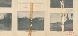
Map of West Vancouver and vicinity : verso
Part of City of Vancouver Archives technical and cartographic drawing collection
Part contains promotional images of West Vancouver and an advertisement for R.P. Matheson Advertising Service.


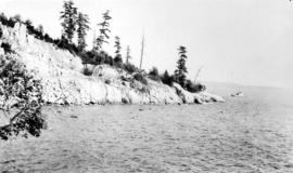
![[Marine Drive near West Bay showing Point Atkinson in the distance]](/uploads/r/null/4/d/4df8d326019887f7b39ac7982fc4dc46b806c358ed8a8f52e62af5d7278d1e68/ef580852-d5ba-49ad-b37e-63a37949bb9b-A09899_142.jpg)
[Marine Drive near West Bay showing Point Atkinson in the distance]
Part of Major Matthews collection

Part of Major Matthews collection

Marine Drive, North Shore, Vancouver, B.C.
Photograph shows a car in the bend in the road.
Part of Hubert William Lovell fonds
Photograph was taken in the summer.
![McNair Fraser logging camp [at] Hollyburn](/uploads/r/null/6/1/6127900d60495b36275d2030b34833c0def918d3be9decbb28759fee910cb52e/d4084822-050b-4a5a-9c65-a7966aa8799d-A32031_142.jpg)
McNair Fraser logging camp [at] Hollyburn
Part of Major Matthews collection
Photograph shows a 'Walking Dudley' hauling logs
![McNair Fraser logging camp [at] Hollyburn](/uploads/r/null/4/3/438cb9f3ea9ffba41568e3e2b27fcc09e3edc5e1ce64634bd8622bb56e1b6c35/1ae97068-fc03-444d-b48f-f4d8a9a5c325-A32033_142.jpg)
McNair Fraser logging camp [at] Hollyburn
Part of Major Matthews collection
Photograph shows the "Walking Dudley' hauling logs
![McNair Fraser logging camp [at] Hollyburn](/uploads/r/null/9/5/9504fc2db10f851a409b0fded43f3e4434d228862b93ccb189f03c60fd2a9fce/43afe828-9389-4e86-b2c2-146d337bd4c0-A32034_142.jpg)
McNair Fraser logging camp [at] Hollyburn
Part of Major Matthews collection
Photograph shows the "Walking Dudley' hauling logs
![McNair Fraser logging camp [at] Hollyburn](/uploads/r/null/d/f/df98bb47791ed76d78beee034253482dcb66148b28f352e3289d25a185769866/660f484b-cba6-45fa-a4ef-cb33fa46a1d2-A32000_142.jpg)
McNair Fraser logging camp [at] Hollyburn
Part of Major Matthews collection
Photograph shows a 'Walking Dudley' for hauling logs by rail
![McNair Fraser logging camp [at] Hollyburn](/uploads/r/null/9/6/96f318e3c66fe037dbd471ce8683420a317a3e095ee637731af77c685232395c/cbfa4cb6-3e4e-45ed-9783-d31ebed73692-A32032_142.jpg)
McNair Fraser logging camp [at] Hollyburn
Part of Major Matthews collection
Photograph shows the booming grounds at Hollyburn Beach
![McNair Fraser logging camp [at] Hollyburn](/uploads/r/null/1/7/17c669b5ffa8e697789ca2d41a25676250c3548ba8c425892509d5b2d825c0a1/3807a641-f32e-4e62-9614-a499d8116603-A32035_142.jpg)
McNair Fraser logging camp [at] Hollyburn
Part of Major Matthews collection
Photograph shows the 'Walking Dudley' hauling logs
Part of C.B.K. Van Norman fonds
File consists of the following types of architectural drawings: rendering of exterior, elevations, and floor plans.

Men standing on ladder leaned against large tree stump
Part of William Orson Banfield fonds
Milton Munn residence : Blk 1 DL 817, West Vancouver
Part of C.B.K. Van Norman fonds
File consists of the following types of architectural drawings: cross section, elevation, floor plan and structural specifications.

Part of William Orson Banfield fonds
![Miss Green and myself [W.O. Banfield]](/uploads/r/null/9/c/a/9ca3399d737a9ce255315ebf266f5628bef3f24e56684a88770bb42f400297fb/6c56a3b7-42e8-4822-8da0-4360a23b99dd-CVA289-002_142.jpg)
Miss Green and myself [W.O. Banfield]
Part of William Orson Banfield fonds

Part of Major Matthews collection
![Mother [Harriet Banfield] and Auntie Bessie at Mr. Henshaws home at Caulfields](/uploads/r/null/6/8/0/680578d4ffed908c428e5f62260d46e56fa23ccec750b9b59a5d0d582ab8cdf4/42595932-1b30-4d5e-8e18-565bc0fc35ea-CVA289-002_142.jpg)
Mother [Harriet Banfield] and Auntie Bessie at Mr. Henshaws home at Caulfields
Part of William Orson Banfield fonds
Item is a photograph showing a group sitting for a portrait on a rock with a view of the ocean in the background. Harriet Banfield is pictured on the far right.
![Mother [Harriet Banfield] and Auntie Bessie at Mr. Henshaws home at Caulfields](/uploads/r/null/3/e/6/3e67eab116c80f32a4edb4b9b87745fc913e5e32fa35a4f0697e54eb536ee2f8/8f35c66f-341a-42f1-bcc3-81b6dbf991e7-CVA289-002_142.jpg)
Mother [Harriet Banfield] and Auntie Bessie at Mr. Henshaws home at Caulfields
Part of William Orson Banfield fonds
Item is a photograph showing a group having tea. Harriet Banfield is pictured seated on the left.
![Mother [Harriet Banfield] and Auntie Bessie at Mr. Henshaws home at Caulfields](/uploads/r/null/9/8/e/98eabbf4b180faae849fa41dc00bdc6a28138aaf61bacc627231f7b44183faad/b44bf21b-564f-4bed-9921-64838b885188-CVA289-002_142.jpg)
Mother [Harriet Banfield] and Auntie Bessie at Mr. Henshaws home at Caulfields
Part of William Orson Banfield fonds
Item is a photograph showing Harriet Banfield and a man sitting on a rock for a portrait.
![Mother [Harriet Banfield] and Auntie Bessie at Mr. Henshaws home at Caulfields](/uploads/r/null/7/3/9/739dc2cb1efb9c63ad891dfe0f61e41ad5132fb4c75da62cd824d5896c539339/37ae6724-af20-46d0-be8a-3c94c0e0e010-CVA289-002_142.jpg)
Mother [Harriet Banfield] and Auntie Bessie at Mr. Henshaws home at Caulfields
Part of William Orson Banfield fonds
Item is a photograph showing a group sitting for a portrait on a rock with a view of the ocean in the background. Harriet Banfield is pictured on the far right.