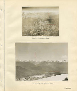
Aerial view - Lower Cheakamus Region and View looking east across Cheakamus Valley
- COV-S40-MAP 939-: LEG1153.036
- Item
- [1931]
Part of City of Vancouver fonds
31 results directly related Exclude narrower terms
Aerial view - Lower Cheakamus Region and View looking east across Cheakamus Valley
Part of City of Vancouver fonds

Cheakamus power survey for City of Vancouver 1930-1931. General plan and profile
Part of City of Vancouver fonds
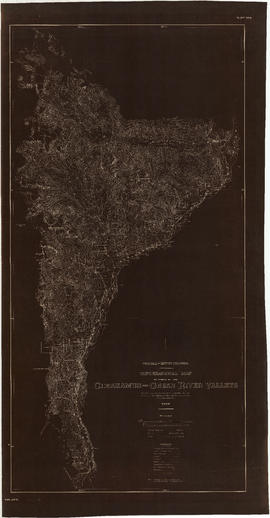
Item is a map depicting south-western British Columbia and noting the location of the area covered by the plates in the atlas. The sheet also includes a profile of the survey area from Cheakamus Lake to Garibaldi Lake.

Part of City of Vancouver fonds
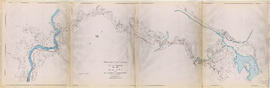
Item is a group of charts depicting flows by month measured at various points along the Cheakamus River.

Part of City of Vancouver fonds
Item is a topographic map of Cheakamus Lake, showing elements of the proposed power infrastructure. The map also includes an inset topographic map of the proposed dam site and a capacity diagram of Cheakamus Lake.

Part of City of Vancouver fonds

Part of City of Vancouver fonds

Part of City of Vancouver fonds
Part of City of Vancouver fonds
Part of City of Vancouver fonds
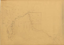
Item is a map which appears to depict a proposed route for a pole line from a power house on the Cheakamus River to the Squamish River, as well as other unidentified sketches.
Cheakamus River. Brandywine Creek to Cheakamus Lake
Part of City of Vancouver fonds
Item is a rough preliminary sketch map of part of the Cheakamus River. The map includes notes on terrain, survey data points, the PGE railway right of way, and District Lots.

Cheakamus River valley with possible dam location
Part of City of Vancouver fonds
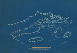
Item is a sheet with three maps depicting a possible dam site on the Cheakamus River: a topographical map of the site with the dam location annotated, a cross-section depicting the geology of the dam site, and a profile of the tentative location of a tunnel.

Cheakamus River with proposed dam site at McGuire
Part of City of Vancouver fonds
Item is a sheet with three maps depicting a possible dam site on the Cheakamus River near McGuire: a topographical map of the site with the dam location annotated, and a cross-section depicting the geology of the dam site.

Contour map shewing proposed location of flume, reservoir and power plant Cheakamus River, B.C.
Part of City of Vancouver fonds
Item is a copy of a map that appears to have been created as part of power development proposal by DuCane, Dutcher & Co. The map was likely acquired by the City Engineer's Office as a reference map for surveying work done in the Cheakamus River area in 1923.

Garibaldi Lake, Daisy Lake and Cheakamus River
Part of City of Vancouver fonds
Item is a sheet containing the following survey photographs: Stillwater below Daisy Lake; Looking up Cheakamus River from canyon dam site; Leakage from Garibaldi Lake through lava into Garibaldi Creek; Looking up-stream from near Cheakamus Canyon power station; Looking up Cheakamus River from P.G.E. Rlwy. bridge Mile 19.1; Looking up Cheakamus River to Daisy Lake dam site; Looking down Cheakamus river from canyon dam site.

Hydro electric survey. Cheakamus River from Squamish River to Brandywine Creek
Part of City of Vancouver fonds

Hydro electric survey City of Vancouver : Cheakamus River system from Squamish River to Green River
Part of City of Vancouver fonds
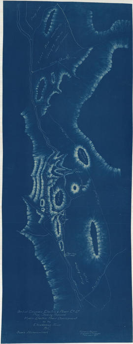
Item is a map which shows a proposed hydro electric development of the Cheakamus River system from the Squamish River to Green Lake. The map includes proposed tunnel routes, diversions, storage reservoirs, dams, power houses, canals, and pipelines. Also shown are areas of suggested future development and the Pacific Great Eastern railway line. Included in the area surveyed are Garibaldi Lake, Starvation Lake, Deadman's Lake, Daisy Lake, Stoney Lake, Cheakamus Lake, Alta Lake, Nita Lake, Alpha Lake, and Green Lake, as well as the Squamish River, Pilchuk River, Cheakamus River, Soo River, Green River, and various creeks.

Hydro electric survey City of Vancouver : Cheakamus River system from Squamish River to Green River
Part of City of Vancouver fonds
Item is a map which shows a proposed hydro electric development of the Cheakamus River system from the Squamish River to Green Lake. The map includes proposed tunnel routes, diversions, storage reservoirs, dams, power houses, canals, and pipelines. Also shown are areas of suggested future development and the Pacific Great Eastern railway line. Included in the area surveyed are Garibaldi Lake, Starvation Lake, Deadman's Lake, Daisy Lake, Stoney Lake, Cheakamus Lake, Alta Lake, Nita Lake, Alpha Lake, and Green Lake, as well as the Squamish River, Pilchuk River, Cheakamus River, Soo River, Green River, and various creeks. Map is hand coloured with pencil annotations concerning watersheds, land height and creeks not included on the original map design.

Junction of Cheakamus and Squamish Rivers and Cheakamus Canyon
Part of City of Vancouver fonds
Plan shewing proposed hydro-electric power development on the Cheakamus River B.C.
Part of City of Vancouver fonds

Plan showing right-of-way through District Lots 2421, 1531, 2498
Part of City of Vancouver fonds
Item is a copy of a map created by the Pacific Great Eastern Railway, showing the right-of-way of their rail line along part of the lower Cheakamus River valley from north of the Cheekye River and a portion of the lower Squamish River. The map also shows the right-of-way through District Lots 1817, 2421 and 2565. The map was most likely acquired by the City Engineer's Office as a reference map for the hydro electric surveys of the Squamish and Cheakamus river systems.

Profile showing levels of Squamish River and portion of Cheakamus River
Part of City of Vancouver fonds
Proposed hydro-electric power development on Cheakamus River
Part of City of Vancouver fonds

Part of William Orson Banfield fonds

Part of William Orson Banfield fonds

The lower valley of the Cheakamus
Part of William Orson Banfield fonds
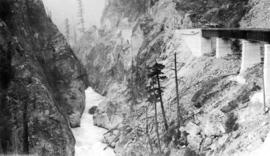
The P.G.E. and the Cheakamus Canyon
Part of William Orson Banfield fonds

The P.G.E. R.R. in the Cheakamus Canyon
Part of William Orson Banfield fonds
Topographical map of parts of the Cheakamus and Green River valleys
Part of City of Vancouver fonds

Topographical map of parts of the Cheakamus and Green River Valleys
Part of City of Vancouver fonds
Item is a copy of a Government of British Columbia Lands Department map which has been used as a base map to depict elements of the proposed development. Annotations depict acreages of affected areas.
Topography of proposed dam site
Part of City of Vancouver fonds
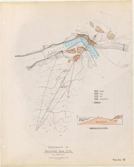
Item is a sheet with two maps depicting a possible dam site on the Cheakamus River: a topographical map of the site with the dam location annotated, and a cross-section depicting the geology of the dam site.