![[A Canada - United States border marker in the ground]](/uploads/r/null/b/5/b509a4b59bc183d084e90f1c08ef31eed0f1528b17bb47a30b128f1d4ed3bcfc/efc7fd87-a69c-44f2-9710-bc1fac4b3c0a-A75682_142.jpg)
[A Canada - United States border marker in the ground]
- AM640-S1-: CVA 260-663
- Item
- 1937
Part of James Crookall fonds
26 results directly related Exclude narrower terms
[A Canada - United States border marker in the ground]
Part of James Crookall fonds
Alaskan boundary : [letter to the editor of the New York Tribune]
![[Boundary Treaty Centennial celebration at the Peace Arch border crossing]](/uploads/r/null/8/f/8f6746f809d4748b7e089d0548004e88a3fcd4369bbffc429b6b34c23bc26879/26e4505c-5a55-444e-ac8f-9160213690ed-A12697_142.jpg)
[Boundary Treaty Centennial celebration at the Peace Arch border crossing]
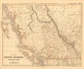
British Columbia and Vancouver Island
Part of City of Vancouver Archives technical and cartographic drawing collection
Item is a map showing the Pacific Coast, Hudson Bay territory, Indian territory, British Columbia, New Caledonia, Russian America, and the north-western United States.

British possessions in North America
Part of City of Vancouver Archives technical and cartographic drawing collection
Item is a map showing British territories and borders with Russian territories, the United States, and Mexico. Includes White population totals for Hudson Bay territory, Upper Canada, Lower Canada, New Brunswick, Nova Scotia, Cape Breton Is., Prince Edward Is., and Newfoundland as well as white population for United States claimed territory, broken down by state.
![Canadian Customs [and Immigration building], Sumas, B.C.](/uploads/r/null/a/1/a1f5e5d9546b4ee23e157d8a21c8652c6b8ac2587135af708a435fa9332789bf/548a8104-33aa-45aa-8c8e-906dd49f227f-A03292_142.jpg)
Canadian Customs [and Immigration building], Sumas, B.C.
![Canadian Customs [and Immigration building], Sumas, B.C.](/uploads/r/null/c/3/c3ce823af211a0fc40594afe868fdbd79027c6a6ef2f8529b221fc2bd4cca81b/7bb1276b-f98f-4e66-9c3a-299489bc12a7-A03291_142.jpg)
Canadian Customs [and Immigration building], Sumas, B.C.
![[Cross sections of ocean floor between Vancouver Island and mainland of British Columbia]](/uploads/r/null/c/a/6/ca687b43e46696a0c1d9223ef1e80ebe50bba0ea48092c458b525fc90f7b517c/7d458083-64ae-4682-be03-8fd1211e38c9-MAP8b_142.jpg)
[Cross sections of ocean floor between Vancouver Island and mainland of British Columbia]
Part of City of Vancouver Archives technical and cartographic drawing collection
Item shows ocean floor cross sections at 49 degrees latitude, 48 degrees 45', 48 degrees 35', and 48 degrees 25'. Islands and other geographical features are indicated.
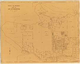
District lot boundaries within the City of Vancouver
Part of City of Vancouver fonds

Fraser River Delta, British Columbia
Part of City of Vancouver Archives technical and cartographic drawing collection
Item is a map of the Fraser River and Lower Mainland showing the following: roads, electric railways and tramways, bridges, churches, schools, post offices, cemeteries, international, municipal, township and city boundaries, wharves, lighthouses, triangulation stations and boundary monuments. Map gives topography of the land and shows water lines, tidal flats and intermittent streams.

Guide map: Vancouver - New Westminster, Burnaby and North Shore municipalities
Part of City of Vancouver Archives technical and cartographic drawing collection
Item is a street map of Vancouver, Burnaby, New Westminster and the North Shore showing city limits and boundaries of central office areas. Map has been annotated to show the old and new Vancouver telephone exchange boundaries prior to and after the introduction of flat rate service on November 1, 1937.
![[Jack Benny and his troupe watching customs officers check their baggage]](/uploads/r/null/e/1/e1cc46a4392225eb06e622227aeb0c0cfa2acb9e2712e32e721e529494087dea/5fe5de18-640d-4ae6-bce8-ab66051d45fe-A10895_142.jpg)
[Jack Benny and his troupe watching customs officers check their baggage]
Left to right: Mary Livingstone, Jack Benny and Eddie Anderson.

Map of Manitoba, Keewatin, British Columbia, and North West Territory
Part of City of Vancouver Archives technical and cartographic drawing collection
Item is a map showing the route of the Canadian Pacific Railway through western Canada.
Part of City of Vancouver Archives technical and cartographic drawing collection
Item is a map showing "Mr. Stuart's route through the United States, and Canada in 1828, 29 & 30" and "the boundary of the United States, both on the side of the British Possessions, & those in Mexico." The northern border of United States territory west of the Rocky Mountains is incorrectly noted at 54/40, to reflect American claims of the time.

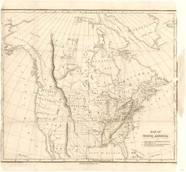
Map of the United States and territories together with Canada etc.
Part of City of Vancouver Archives technical and cartographic drawing collection
Item is a map showing the boundaries of U.S. territories and states and the southern portion of Canadian colonies of Vancouver Island, British Columbia, Canada East, Canada West, as well as New Brunswick, Prince Edward Island and Nova Scotia. The map also shows cities and principal geographical features. Two inset maps show "Hampton Roads and Norfolk Harbour" and "Pensacola Bay" in greater detail.
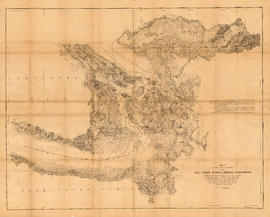
Map showing the line of boundary between the United States and British possessions
Part of City of Vancouver Archives technical and cartographic drawing collection
Item is a map showing four proposed boundaries between the United States and British possessions in the Salish Sea region. The explanations of the lines read in part: "[1] Boundary line contemplated by the Treaty as shown by contemporaneous evidence; [2] Boundary line as claimed by the British Commissioner; [3] Boundary line proposed by the British Commissioner as a compromise ( . . . ); [4] Boundary line in accordance with the strict letter of the Treaty ( . . . ). Item also shows soundings, and the "track of steamers plying between Victoria and Fraser river since discovery of gold."
Report relative to the Alaskan Boundary Question
Review of the Alaska boundary question
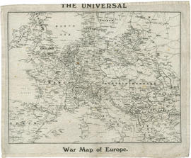
The universal war map of Europe
Part of A. Stewart McMorran 29th (Vancouver) Battalion collection
Item is a map of most of Europe showing countries, cities, and some bodies of water.
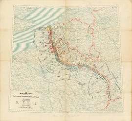
The Western Front : situation on September 25, 1918
Part of A. Stewart McMorran 29th (Vancouver) Battalion collection
Item is a map of part of Europe showing distribution of military divisions by nationality along the Western Front.


Vancouver : urban growth, 1865-1970
Part of City of Vancouver Archives technical and cartographic drawing collection
Item is a map that shows the boundaries between Vancouver, Point Grey, Hastings Townsite, South Vancouver and District Lot 301, and how these evolved over time.

Part of City of Vancouver Archives technical and cartographic drawing collection
Item is a topographical map showing lands alienated or covered by application under the Land Act, timber leases, native reserves, government reserves, and various boundaries, as well as campsites, picnic sites, forest service lookouts, post offices, settlements, schools, hospitals, mines, dykes, historic monuments, roads, trails, railways, power lines, phone lines, air harbour or seaplane anchorages, etc. Sheet contains an index map showing adjoining maps in the series.